

North Carolina map
Union County map
About 263,386 people live here (Census Bureau, 2024 estimate). The sheet's index lists 93 streets; Monroe Expressway, Potter Road South and Secrest Short Cut Road cross the most grid squares. Also on it: Abellia Estates, Acorn Woods and Addington Crossing.
Open the map (PDF, US Letter)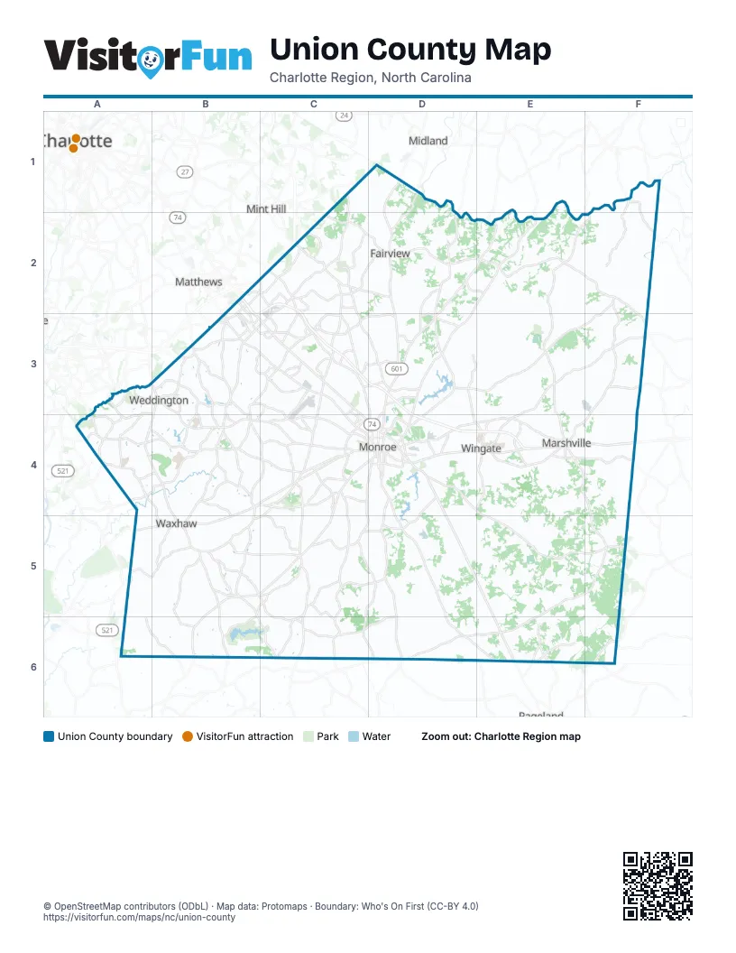
Street index of Union County
Each street on the sheet and the grid squares it crosses.
- Concord HighwayD1, D2, D3
- Guion LaneB2
- Independence BoulevardB2, B3, C3
- Monroe ExpresswayB2, C2, B3, C3, D3, D4, E4
- Stallings Commerce DriveB2
- Stallings RoadB2, C2, B3
- Idlewild RoadC2
- Indian Trail Fairview RoadC2, D2, C3
- Lawyers RoadC2
- North Rocky River RoadC2, C3, C4
- Ridge RoadC2, C3, D3
- Secrest Short Cut RoadC2, C3, D3, D4
- Morgan Mill RoadD2, E2, D3, D4
- Providence RoadA3, B3
- Rea RoadA3, A4, B4
- Chestnut LaneB3
- East John StreetB3
- Goldmine RoadB3, C3, C4
- Matthews Weddington RoadB3
- North Indian Trail RoadB3, C3
- Old Monroe RoadB3, C3
- Providence Road SouthB3, A4, B4
- South Indian Trail RoadB3
- Tilley Morris RoadB3
- Traffic CircleB3
- Unionville Indian Trail Road WestB3, C3, D3
- Waxhaw Indian Trail RoadB3, B4
- Weddington Matthews RoadB3
- Weddington RoadB3, B4, C4
- Wesley Chapel RoadB3, C3, B4
- Old Charlotte HighwayC3, C4
- Sardis Church RoadC3
- Wesley Chapel Stouts RoadC3
- West Roosevelt BoulevardC3, C4, D4
- West Unionville Indian Trail RoadC3
- Chaney RoadD3
- Skyway DriveD3, D4
- Jim Wilson RoadA4
- Kensington DriveA4, B4
- New Town RoadA4, B4, C4
- Cuthbertson RoadB4
- North Broome StreetB4, B5
- Potter Road SouthB4, C4, B5, B6, C6
- South Potter RoadB4, B5
- Waxhaw HighwayB4, C4, A5, B5
- Waxhaw Indian Trail Road SouthB4, B5
- Dickerson BoulevardC4
- Engleside StreetC4
- Iceman StreetC4, D4
- Lancaster AvenueC4, D4
- Lancaster HighwayC4, B5, C5, B6
- M L King Jr BoulevardC4
- North Charlotte AvenueC4, D4
- South Rocky River RoadC4, C5, C6
- West Franklin StreetC4, D4
- Andrew Jackson HighwayD4, E4
- Charles StreetD4
- East East AvenueD4
- East Franklin StreetD4
- East Jefferson StreetD4
- East Roosevelt BoulevardD4
- Franklin StreetD4
- Macedonia Church RoadD4
- Mangum Dairy RoadD4
- Marion Lee RoadD4
- North Church StreetD4
- North Hayne StreetD4
- North Johnson StreetD4
- Pageland HighwayD4, D5, E5, E6
- South Charlotte AvenueD4
- South Hayne StreetD4
- West Jefferson StreetD4
- Wolf Pond RoadD4, D5, D6
- Austin Chaney RoadE4
- Carroll M. Edwards HighwayE4, F4
- East Main StreetE4
- East Marshville BoulevardE4, F4
- North Elm StreetE4
- North Main StreetE4
- West Marshville BoulevardE4
- W. Cliff Martin HighwayF4
- East South Main StreetB5
- Howie Mine RoadB5
- McDonald StreetB5
- Old Providence RoadB5
- Old Waxhaw Monroe RdB5
- West South Main StreetB5
- Carl Funderburk RoadD5
- Claude Austin RoadD5
- Griffin Cemetery RoadD5
- McManus CircleD5
- Hargette RoadE5
- Landsford RoadE6
Places on the map
- Abellia Estates
- Acorn Woods
- Addington Crossing
- Adelaide Estates
- Aero Plantation
- Aero Plantation Airport
- Aerowood
- Alexis Pointe
- Allenby Place
- Alma Village
- Altan Ridge
- Alton Woods
- Amber Meadow
- Anklin Forest
- Annandale
- Anniston Grove
- Antioch Plantation
- Antioch Woods
- Appaloosa Pointe
- Arant Airport
- Arbor Glen
- Arbor Way
- Arlington Downs
- Asbury Downs
- Ashe Croft
- Ashley Hall
- Atherton Estates
- Atrium Health Union
- Atrium Health Union Heliport
- Atrium Health Union West
- Aubert Landing
- Austin Hills
- Autumn Sage Drive
- Avondale Park
- Baker Quarry Lake
- Bakers Quarry
- Barbee Farms
- Baron Road
- Barrington Ridge
- Beacon Hills
Next to Union County
- Charlotte map
- Matthews
- Midland
- Mint Hill
- Pageland
© OpenStreetMap contributors (ODbL) · Map data: Protomaps · Boundary: Who's On First (CC-BY 4.0)