

North Carolina map
Charlotte map
About 943,476 people live here (Census Bureau, 2024 estimate). The sheet's index lists 196 streets; East W T Harris Boulevard, Governor James G Martin Freeway and Craig Lawing Freeway cross the most grid squares. Things to do inside the boundary: Billy Graham Library, Discovery Place Science and NASCAR Hall of Fame.
Open the map (PDF, US Letter)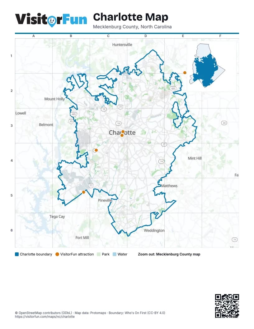
Street index of Charlotte
Each street on the sheet and the grid squares it crosses.
- Craig Lawing FreewayC1, B2, C2, B3
- H Allen Tate Jr HighwayC1, D1
- Mount Holly-Huntersville RoadC1, B2, C2
- Northlake Centre ParkwayC1, C2
- Statesville RoadC1, C2, C3
- West W T Harris BoulevardC1, C2, D2
- Asbury Chapel RoadD1
- Benfield RoadD1
- Browne RoadD1, D2
- Craven Thomas RoadD1
- DeArmon RoadD1
- Eastfield RoadD1
- Hucks RoadD1, D2
- Johnston Oehler RoadD1
- Mallard Creek RoadD1, D2
- Old Statesville RoadD1, C2, D2
- Prosperity Church RoadD1, D2
- Prosperity Ridge RoadD1
- Ridge RoadD1
- Robert Helms RoadD1
- Bellhaven BoulevardB2, C2
- Brookshire BoulevardB2, C2, C3
- Freedom DriveB2, B3, C3
- Mount Holly RoadB2
- Beatties Ford RoadC2, C3
- Bill Lee FreewayC2, C3, C4
- Cindy LaneC2, D2
- Fred D. Alexander BoulevardC2, B3, C3
- Gibbon RoadC2, D2
- I 77 Express LanesC2, C3
- I-77 NorthC2, C3
- I-77 SouthC2, C3
- Lakeview RoadC2, D2
- Oakdale RoadC2
- Old Plank RoadC2
- Reames RoadC2, D2
- Sunset RoadC2
- David Cox RoadD2
- East W T Harris BoulevardD2, E2, D3, E3, D4, E4
- Hubbard RoadD2
- I-85 ConnectorD2
- Jeff Gordon ExpresswayD2
- Julius Chambers HighwayD2, C3, D3
- Nevin RoadD2
- North Graham StreetD2, C3, D3
- North Tryon StreetD2, E2, C3, D3
- University City BoulevardD2, E2
- West Mallard Creek Church RoadD2, E2
- West Sugar Creek RoadD2, D3
- East Mallard Creek Church RoadE2
- Governor James G Martin FreewayE2, C5, D5, E5, D6
- Pavilion BoulevardE2
- Salome Church RoadE2
- Boyer StreetB3, C3
- DeparturesB3
- Josh Birmingham ParkwayB3
- Little Rock RoadB3
- Moores Chapel RoadB3
- North Josh Birmingham ParkwayB3
- Old Mount Holly RoadB3
- Rhyne Rd and Moores Chapel Rd RoundaboutB3
- Sam Wilson RoadB3
- Wilkinson BoulevardB3, C3
- Atando AvenueC3, D3
- Billy Graham ParkwayC3, C4
- Brookshire FreewayC3, D3
- Carson BoulevardC3
- Charlottetowne AvenueC3, D3
- Church Street ConnectorC3
- Clanton RoadC3, C4
- Dalton AvenueC3, D3
- East 11th StreetC3, D3
- East 12th StreetC3, D3
- East 13th StreetC3
- East 3rd StreetC3, D3
- East 4th StreetC3, D3
- East 5th StreetC3
- East 7th StreetC3, D3
- East BoulevardC3
- East Brooklyn Village AvenueC3
- East Good Samaritan WayC3
- East Morehead StreetC3, C4
- East Trade StreetC3
- Elizabeth AvenueC3
- John Belk FreewayC3, D3
- John Belk Freeway WestC3
- Johnson and Wales WayC3
- Kenilworth AvenueC3, C4
- LaSalle StreetC3
- North Brevard StreetC3
- North Caldwell StreetC3, D3
- North Church StreetC3, D3
- North College StreetC3
- North Kings DriveC3, D3
- North McDowell StreetC3, D3
- Old Steele Creek RoadC3
- Remount RoadC3, C4
- Scott AvenueC3, C4
- South BoulevardC3, C4, C5
- South Caldwell StreetC3
- South Cedar StreetC3
- South Church StreetC3
- South Clarkson StreetC3
- South College StreetC3
- South Graham StreetC3
- South Kings DriveC3, C4
- South McDowell StreetC3
- South Mint StreetC3
- South Tryon StreetC3, B4, C4, B5
- Statesville AvenueC3
- Tuckaseegee RoadC3
- West 10th StreetC3
- West 11th StreetC3
- West 12th StreetC3
- West 3rd StreetC3
- West 4th StreetC3
- West 4th Street ExtensionC3
- West 5th StreetC3
- West 7th StreetC3
- West BoulevardC3, B4, C4
- West Brooklyn Village AvenueC3
- West Carson BoulevardC3
- West Good Samaritan WayC3
- West Morehead StreetC3
- West Trade StreetC3
- West Tyvola RoadC3, C4
- Westley Village RoadC3
- Central AvenueD3, D4
- East 10th StreetD3
- East Independence BoulevardD3, D4, E4
- East Independence ExpresswayD3, D4
- East Sugar Creek RoadD3
- Eastway DriveD3, D4
- Monroe RoadD3, D4
- North Davidson StreetD3
- North Sharon Amity RoadD3, D4
- Parkwood AvenueD3
- Providence RoadD3, D4, D5, D6
- Queens RoadD3, C4, D4
- Randolph RoadD3, D4
- The PlazaD3
- Albemarle RoadE3, D4, E4
- Harrisburg RoadE3
- Lawyers RoadE3, E4
- Brown Grier RoadB4
- Byrum DriveB4
- Piney Top DriveB4
- Seddon "Rusty" Goode FreewayB4, C4, C5
- Steele Creek RoadB4, B5
- West Arrowood RoadB4, C4
- Westinghouse BoulevardB4, B5, C5
- East Arrowood RoadC4
- East Woodlawn RoadC4
- Fairview RoadC4, D4
- General Paul R Younts ExpresswayC4, B5, C5
- Park RoadC4, C5
- Quail Hollow RoadC4, C5, D5
- Runnymede LaneC4, D4
- Sharon RoadC4, D4, C5
- Tyvola RoadC4
- West Woodlawn RoadC4
- Carmel RoadD4, C5, D5
- Carnegie BoulevardD4
- Colony RoadD4, D5
- Conference DriveD4
- Idlewild RoadD4, E4
- MonroeD4
- North Wendover RoadD4
- Rama RoadD4
- Reddman RoadD4
- Sardis RoadD4, D5
- Sharon LaneD4
- South Sharon Amity RoadD4
- South Wendover RoadD4
- Independence BoulevardE4
- B. Bayles Mack HighwayB5
- Carowinds BoulevardB5
- York RoadB5
- East Westinghouse BoulevardC5
- I-485 Express LanesC5, D5, D6
- Johnston RoadC5, C6
- Lancaster HighwayC5, C6
- Pineville RoadC5
- Pineville-Matthews RoadC5, D5
- Sharon Road WestC5
- Ballantyne Commons ParkwayD5, C6, D6
- McKee RoadD5, E5
- Rea RoadD5, D6
- Tilley Morris RoadD5, D6
- Weddington RoadE5
- Charlotte HighwayC6
- Providence Road WestC6, D6
- Upper AvenueC6
- Ardrey Kell RoadD6
- Bryant Farms RoadD6
- Elm LaneD6
Things to do on the Charlotte map
Places on the map
- 59Twenty @ Monroe
- 8 Metro Station
- 901 Place
- AAA Carolinas
- Abberly Commons
- Abberly Woods
- Abbotswood
- Abbotts Glen
- Adams Beverages
- Adare
- ADESA Charlotte
- Ainsley
- Airport Plaza
- Airport South Logistics Park
- Aldersgate
- Alexander Funeral Home
- Alexander Hall
- Alexander Place
- Alexander Village Apartments
- Alexander Woods
- Alexsis
- Allen Hills
- Allora Ashley Park
- Allyson Park
- Alpine Village
- Alta Grove
- Alvin Hills
- Amarillo Park
- Amay James Park
- Amber Leigh
- Amber Ridge
- Amberwood
- AMC Carolina Pavilion 22
- Amity Garden
- Andover Woods
- Ansley Falls
- Anson at the Lakes
- Anthem
- Apple Gate
- Apple Tree Village
Next to Charlotte
- Belmont
- Concord
- Fort Mill
- Harrisburg
- Huntersville
- Lowell
- Matthews
- Mint Hill
- Mount Holly
- Pineville
- Tega Cay
- Weddington
© OpenStreetMap contributors (ODbL) · Map data: Protomaps · Boundary: Who's On First (CC-BY 4.0)