

Nebraska map
Douglas County map
About 601,158 people live here (Census Bureau, 2024 estimate). The sheet's index lists 173 streets; West Maple Road, Highway 36 and Ida Street cross the most grid squares. Things to do inside the boundary: Boys Town, Joslyn Art Museum and Old Market.
Open the map (PDF, US Letter)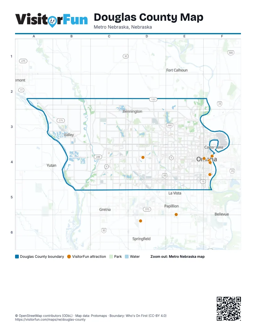
Maps inside Douglas County
1 map inside, from the street map of Douglas County down.
Street index of Douglas County
Each street on the sheet and the grid squares it crosses.
- Highway 36A2, C2, D2, D3
- Pawnee RoadA2, B2, C2
- Reichmuth RoadA2
- North 204th StreetC2, C3, C4
- Highway 133D2, D3
- North 156th StreetD2, D3, D4
- State Highway 133D2, D3
- Calhoun RoadE2, E3
- Ida StreetA3, B3, D3, E3
- North 276th StreetB3
- West Maple RoadB3, C3, D3, C4, D4
- Fort StreetC3, D3, E3
- North 168th StreetC3, C4
- North 180th StreetC3, C4
- North 192nd StreetC3, C4
- Bennington RoadD3, E3
- Blair High RoadD3, E3
- Military RoadD3, E3
- North 101st StreetD3
- North 103rd StreetD3
- North 108th StreetD3, D4
- North 120th StreetD3, D4
- North 132nd StreetD3, D4
- North 144th StreetD3, D4
- North 99th StreetD3
- Ames AvenueE3, F3
- Arthur C Storz ExpresswayE3, F3
- Craig AvenueE3
- Crown Point AvenueE3
- Dick Collins RoadE3
- Fontenelle BoulevardE3, E4
- Hartman AvenueE3
- Highway 75E3
- Irvington RoadE3
- John J Pershing DriveE3, F3
- Martin AvenueE3
- McKinley StreetE3
- Military AvenueE3, E4
- Mormon Bridge RoadE3
- North 30th AvenueE3
- North 30th StreetE3, E4
- North 31st StreetE3
- North 36th AvenueE3
- North 36th StreetE3
- North 42nd StreetE3, E4
- North 52nd StreetE3, E4
- North 60th StreetE3, E4
- North 72nd StreetE3, E4
- North 90th StreetE3, E4
- North FreewayE3, E4
- Sorensen ParkwayE3
- Abbott DriveF3, F4
- Commercial AvenueF3
- North 16th StreetF3, F4
- North 24th StreetF3, F4
- Terminal DriveF3, F4
- County Road MB4
- North 240th StreetB4
- South 240th StreetB4
- West Center RoadB4, C4, D4, E4
- Blondo ParkwayC4
- Blondo StreetC4, D4, E4
- Pacific StreetC4, D4, E4
- South 168th StreetC4, C5
- South 180th StreetC4, C5
- South 192nd StreetC4, C5
- South 204th StreetC4, C5
- West Dodge RoadC4, D4, E4
- Bob Boozer DriveD4
- California StreetD4, E4
- I StreetD4
- Industrial RoadD4, D5
- Maple StreetD4, E4
- North 102nd StreetD4
- North 108th AvenueD4
- Regency ParkwayD4
- South 108th StreetD4, D5
- South 120th StreetD4, D5
- South 132nd StreetD4, D5
- South 144th StreetD4, D5
- South 156th StreetD4, D5
- West Dodge Frontage Road NorthD4
- West Dodge Frontage Road SouthD4
- West Dodge Road ExpresswayD4
- 72nd StreetE4
- Beverly DriveE4
- Capitol AvenueE4
- Cass StreetE4
- Center StreetE4
- Country Club AvenueE4
- Cuming StreetE4, F4
- Dodge StreetE4, F4
- Douglas StreetE4, F4
- Ed Creighton AvenueE4
- F StreetE4, F4
- Farnam DriveE4
- Farnam StreetE4, F4
- Fontanelle BoulevardE4
- Frederick StreetE4
- Gerald R Ford ExpresswayE4, F4
- Gold StreetE4
- Grover StreetE4
- Hamilton StreetE4, F4
- Harney StreetE4, F4
- Kennedy FreewayE4, E5, F5
- Lake StreetE4, F4
- Leavenworth StreetE4, F4
- Lincoln BoulevardE4
- Martha StreetE4, F4
- Mercy RoadE4
- North 40th StreetE4
- North 45th StreetE4
- North 76th StreetE4
- North 78th StreetE4
- North 84th StreetE4
- North Saddle Creek RoadE4
- Northwest Radial HighwayE4
- Ridgewood AvenueE4
- Rose Blumkin DriveE4
- Saint Mary's AvenueE4, F4
- South 28th StreetE4
- South 29th StreetE4
- South 31st StreetE4
- South 32nd AvenueE4
- South 42nd StreetE4, E5
- South 50th StreetE4, E5
- South 51st StreetE4
- South 60th StreetE4, E5
- South 67th StreetE4
- South 72nd StreetE4, E5
- South 78th StreetE4
- South 84th StreetE4, E5
- South 90th StreetE4
- South Saddle Creek RoadE4
- Underwood AvenueE4
- Bob Gibson BoulevardF4
- Chicago StreetF4
- Deer Park BoulevardF4
- East Locust StreetF4
- Florence BoulevardF4
- Howard StreetF4
- Locust StreetF4
- North 10th StreetF4
- North 13th StreetF4
- North 14th StreetF4
- North 19th StreetF4
- North 20th StreetF4
- South 10th StreetF4
- South 13th StreetF4, F5
- South 14th StreetF4
- South 19th StreetF4
- South 20th StreetF4
- South 24th AvenueF4
- South 24th StreetF4, F5
- South 25th StreetF4
- Vinton StreetF4
- Harrison StreetC5, D5, E5
- Highway 6/31C5
- Q StreetC5, D5, E5, F5
- Giles RoadD5
- L StreetD5, E5, F5
- Millard AvenueD5
- South 96th StreetD5
- Main StreetE5
- Miller AvenueE5
- Oakwood StreetE5
- South 26th AvenueE5
- South 36th StreetE5
- South 48th StreetE5
- South 80th StreetE5
- Missouri AvenueF5
- Railroad AvenueF5
- Veterans Memorial HighwayF5
Things to do on the Douglas County map
Places on the map
- 'Siderborough
- 3M Company Valley
- Adams Park
- Aksarben Drive Grassy Area
- Al Veys Youth Sports Complex
- Altech
- Ambrust Oaks
- Ambrust Oaks Estates
- American Concrete Products
- Anchor Pointe
- Anchor View
- Antler View Apartments
- Applewood Heights
- Arbor Gate
- Arbor Heights
- Arbor Ridge 2nd Addition
- Arbor View
- Arcadia Ridge
- Armbrusts Rockbrook
- Avenue One Development
- Barrington Park
- Bauermeister Prairie
- Beckwith Place
- Bedford Hill Woods
- Beechwood
- Bel-Air Village
- Bennington
- Bennington Lake
- Benson
- Benson Park
- Benson Park Golf Course
- Bent Creek
- Bent Creek Park
- Blue Sage Creek
- Blue Sage Creek 2
- Blue Sage Grassland
- Blue Sage Lake
- Bluestem Meadows
- Bluestem Prairie Preserve
- Bonita
Next to Douglas County
- Bellevue
- Carter Lake
- Council Bluffs
- Fort Calhoun
- Fremont
- Gretna
- La Vista
- Papillion
- Springfield
- Yutan
© OpenStreetMap contributors (ODbL) · Map data: Protomaps · Boundary: Who's On First (CC-BY 4.0)