

New Jersey map
Freehold map
About 12,530 people live here (Census Bureau, 2024 estimate). The sheet's index lists 124 streets; Stokes Street, Court Street and West Main Street cross the most grid squares. Things to do inside the boundary: Monmouth County Historical Association.
Open the map (PDF, US Letter)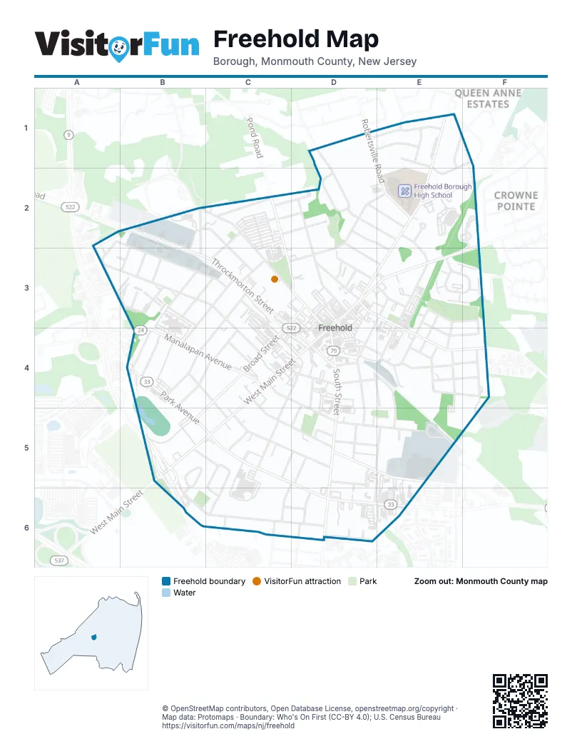
Street index of Freehold
Each street on the sheet and the grid squares it crosses.
- Brookwood DriveD1, D2
- Mead AvenueD1, E1
- Robertsville RoadD1, E2
- Schiverea AvenueD1, E1
- Boulevard DriveE1
- Braun PlaceE1
- Broadway RoadE1, E2, D3, E3
- Douglas RoadE1
- Hall RoadE1
- Hance BoulevardE1, E2
- Runyon AvenueE1
- Stokes StreetA2, B2, A3, B3, C3, C4
- Avenue AB2, C2, C3
- Bannard StreetB2, B3, C3
- Court StreetB2, C2, C3, D3, D4
- Freehold-Englishtown RoadB2
- John StreetB2, B3
- Rhea StreetB2, B3
- Throckmorton StreetB2, B3, C3, D4
- Avenue CC2, C3
- Birch DriveC2, D2
- Crestwood DriveC2, D2
- Edgewood DriveC2, D2
- Holmes TerraceC2
- Monument StreetC2, C3, D3
- Quin BoulevardC2
- Dogwood LaneD2
- Ellis StreetD2, E2
- Fulton StreetD2, E3
- Lockwood AvenueD2, E2
- Morris StreetD2, D3
- Murray StreetD2, D3, E3
- Oak StreetD2, E2
- Schanck StreetD2, C3, D3
- Duncan WayE2, F2, F3
- Dutch Lane RoadE2
- Jackson TerraceE2, E3
- Mc Elwaine DriveE2
- McElwaine DriveE2
- Kingsley WayA3, B3
- Vine StreetA3, B3
- Bowne AvenueB3, C3, B4
- Lenoir AvenueB3
- Thomas StreetB3
- Vought AvenueB3, C3
- Ward AvenueB3
- William StreetB3
- Broad StreetC3, D3, C4, B5
- Haley StreetC3
- Monmouth AvenueC3, B4, C4
- Center StreetD3, E3, E4, F4
- East Main StreetD3, E3, F3
- Henry StreetD3
- Lafayette StreetD3
- Sheriff StreetD3
- Spring StreetD3
- Spring TerraceD3
- Wayne AvenueD3
- West Main StreetD3, C4, D4, B5, C5
- 1st StreetE3, E4
- 2nd StreetE3, E4
- 3rd StreetE3, E4
- Bennett StreetE3
- Bond StreetE3, E4, F4
- Hudson StreetE3, D4
- Jackson StreetE3, E4
- Liberty StreetE3, F3, F4
- Zlotkin CircleE3, F3
- Ann StreetB4
- Frances DriveB4
- Manalapan AvenueB4, C4
- Park AvenueB4, B5, C5, D6, E6
- Phyliss DriveB4
- West George StreetB4, C4
- Yard AvenueB4, C4, C5
- Club PlaceC4
- East George StreetC4
- Hull AvenueC4, C5, D5
- Kiawah AvenueC4, D4, C5
- Lincoln PlaceC4, D4, D5
- Mc Lean StreetC4, D4
- Conover StreetD4, D5
- Cottage PlaceD4, D5
- Elm StreetD4
- Marcy StreetD4
- Mechanic StreetD4, E4
- Parker StreetD4, E4, D5, E5
- Railroad AvenueD4, E4
- Randolph StreetD4, D5
- South StreetD4, D5, D6
- Factory StreetE4
- Ford AvenueE4, F4
- Lloyd StreetE4
- Mc Dermott StreetE4, F4
- Orchard StreetE4, E5
- Otterson RoadE4, F4
- 4th StreetF4
- Barkalow AvenueB5, B6, C6, D6
- Enright AvenueB5, C5, C6
- Reid WayB5, B6
- Berkeley PlaceC5
- Brinckerhoff AvenueC5, D5
- Lawrence PlaceC5, C6
- Prospect PlaceC5, D5
- Sunset AlleyC5
- Sunset CourtC5
- Brentwood AvenueD5, C6
- Clinton StreetD5
- Institute StreetD5, E5
- Jerseyville AvenueD5, E5
- Short StreetD5, D6
- Stillwell PlaceD5
- Union AvenueD5, E5
- Vredenberg AvenueD5
- Washington StreetD5
- Kondrop WayE5
- Helen AvenueB6, C6, D6
- Briar RoadC6, D6
- East Barbara DriveC6
- Michael LaneC6
- Patten StreetC6
- West Barbara DriveC6
- Pittenger AvenueD6
- Waverly PlaceD6
Things to do on the Freehold map
Places on the map
- Abraham Lincoln Bust
- American Hotel
- Antonios Mexicanos
- Charkol
- Church of God
- Columbia Triumphant
- Columbia Triumphant Park
- Corp. Jame Gere Park
- Court Jester
- CPC Integrated Health
- Dibra Community Center of New Jersey
- Downtown Freehold
- El Meson
- Empanada Guy Restaurant
- FastFixCell
- Federici's Family Italian Restaurant
- First Presbyterian Church
- Forman Park
- Freehold Borough Fire Department
- Freehold Borough High School
- Freehold Borough Municipal Building
- Freehold Center Bus Station
- Freehold EMS
- Freehold Little League
- Freehold Memorian Triangle
- Freehold Public Library
- Freehold Raceway
- Habitat for Humanity ReStore
- Henderson's
- Liberty Street and YMCA "Kaboom" Park
- Monmouth Battle Monument Park
- Monmouth County Courthouse
- Monmouth County Historical Association
- Saint Peter's Episcopal Church
- Saint Rose of Lima Chapel
- Saint Rose of Lima Roman Catholic Church
- St. Rose Lima Field
- Veterans Park
Next to Freehold
- Crowne Pointe
- Queen Anne Estates
© OpenStreetMap contributors, Open Database License, openstreetmap.org/copyright · Map data: Protomaps · Boundary: Who's On First (CC-BY 4.0); U.S. Census Bureau















