

New Jersey map
Little Egg Harbor Township map
About 21,587 people live here (Census Bureau, 2024 estimate). The sheet's index lists 300 streets; Garden State Parkway, Radio Road and Great Bay Boulevard cross the most grid squares. Also on it: Jacques Cousteau National Estuarine Research Reserve, East Plains Natural Area and Great Bay Boulevard Wildlife Management Area.
Open the map (PDF, US Letter)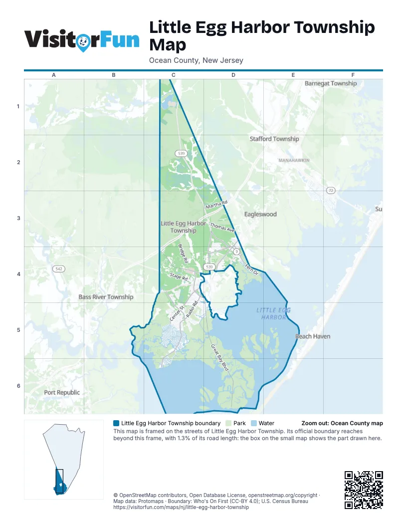
Street index of Little Egg Harbor Township
Each street on the sheet and the grid squares it crosses.
- Garden State ParkwayC3, D3, C4
- North Green StreetD3, D4
- East Main StreetD4
- Main StreetC1
- Radio RoadC4, C5, C6
- Mathistown RoadC4, C5
- Thomas AvenueD3
- Great Bay BoulevardD4, D5, D6
- Nugentown RoadC4, D4
- Center StreetC4, C5
- Parkertown DriveD3, D4
- Railroad DriveD3, D4
- Fern DriveD4
- Frog Pond RoadD4
- Oak LaneC4, D4
- Martha RoadD3
- Giffordtown LaneC4
- Dock StreetD4
- Wood StreetD4
- Walnut StreetD3, D4
- Mill StreetD3
- Poorman's ParkwayC3, D3, C4
- Stage RoadC4
- Otis Bog RoadC4, C5
- Twin Lakes BoulevardC5
- Country Club BoulevardC5
- Golf View DriveD4
- Bridge RoadC3, C4
- Bombing Range RoadC2
- Newport WayD3, D4
- West Cala Breeze WayC5
- Ivy Creek DriveC4
- Lake Champlain DriveC5
- Lexington DriveC5
- Seameadow DriveD4
- Atlantis BoulevardC5, D5
- National Union BoulevardC5
- Briarwood DriveC4
- Valley Forge DriveC5
- Leitz BoulevardC4
- Forest Edge DriveC4
- Windstar DriveC4
- Harbourtown BoulevardC5
- Lake Superior DriveC5
- Oak Leaf DriveC4
- Vacari WayC4, C5
- Cedarbrook LaneC5
- Marketplace DriveC4
- Falcon DriveC5
- Lake Crystalbrook DriveC5
- Ocean BoulevardC5, C6
- Cable DriveD4
- Stafford Forge RoadD3
- Jared LaneC5, D5
- South Shore DriveC2
- Pinehurst DriveC5
- Stonegate DriveC5
- Westchester DriveC5
- West Anchor DriveC5
- Ohio DriveC6
- Chatham RoadD3, D4
- Maplewood DriveD4
- Kadlubeck WayC5
- My WayC4
- Elmwood DriveD4
- Saint Andrews DriveC5
- Hollybrook DriveC5
- Water's Edge DriveC4, C5
- Greenside DriveC5
- Galley WayD3, D4
- Hamble RoadD3
- North Ensign DriveC5
- Timberline DriveC4, C5
- Shenandoah DriveC5
- Gaskill DriveC5
- Gimble RoadD3
- Beaver Dam RoadC1
- Kentucky DriveC6
- Lantern PlaceC5
- Cherrywood DriveD4
- Sycamore DriveC5
- South Spinnaker DriveC5
- Baker's LaneD3
- Winding Wood DriveC4
- Fire House DriveD4
- Mohican LaneC5
- Sunrise Bay BoulevardC4
- Tony's DriveC4
- Yorktowne DriveC5
- Pinewood DriveD4
- Brook StreetD4
- White Oak LaneD3, D4
- Beach DriveC5, C6
- Danbury DriveC5
- Vincent CourtC4
- Kansas RoadC5, C6
- Nautic WayC4
- John StreetC4
- Hancock DriveC5
- North Spinnaker DriveC5
- Coconut Custard LaneD3
- Seagull DriveC4
- Harvest WayC4, C5
- Marigold LaneC4
- South Burgee DriveC5
- Willets AvenueD3
- Maryland RoadC6
- South Captain DriveC5
- Hampton DriveD4
- South Pulaski BoulevardC5
- Daffodil DriveC4
- Simm Place RoadC1
- East Raritan DriveC5
- West Susquehanna DriveC5
- Staysail DriveC5
- Lake Winnepesaukee DriveC5
- Louisiana DriveC5, C6
- Lake Michigan DriveC5
- Franklin AvenueC4, D4
- Persimmon DriveD4
- Plantation DriveC5
- Hunter DriveC5, D5
- Boulder Lake DriveC5
- Mountain Lake RoadC5
- Willowbrook LaneC5
- Radio Tower RoadC1
- Lake Placid DriveC5
- Blueberry Pie LaneD3
- Welch CourtC4
- Flax Isle DriveD5
- Rosewood DriveD4
- Revere DriveC4
- West Potomac DriveC5
- North Burgee DriveC5
- South Ensign DriveC5
- Mayflower DriveC4
- South Longboat DriveC5
- Lighthouse DriveC5
- Sea Breeze DriveD3, D4
- Juniper DriveD4
- Tall Timber DriveC5
- Taylor StreetC4
- Bunker DriveD4
- Iowa CourtC6
- Lake Medford LaneC5
- old Ice House roadC4
- Lakewood CourtC5
- Seneca Lake DriveC5
- East Susquehanna DriveC5
- Revolutionary DriveC4
- Storys LaneD3
- West Mohawk DriveC5
- Hickory LaneD4
- Stagecoach DriveC4
- Cheesecake LaneD3
- Lake Huron DriveC5
- West Raritan DriveC5
- Laurel LaneC4
- Daddy Tucker DriveD5
- Carolyn DriveC4
- Falkinburg DriveC5
- South Forecastle DriveC5
- East Potomac DriveC5
- Hartley LaneC4, D4
- Pembrook CourtC4
- Colonial DriveC5, D5
- Cayuga Lake DriveC5
- East Playhouse DriveC5
- East Hudson DriveC5
- West Navasink DriveC5
- Hannah PlaceC4
- Lakeside DriveC4, D4
- Abbie DriveC4
- West Sail DriveC5
- Sherwood DriveC5
- East Schuylkill DriveC5
- North Captain DriveC5
- Pin Oak LaneC5
- Arlene DriveC4
- East Navasink DriveC5
- Oakland Bay CourtC5
- Boom WayC5, D5
- Greenwood Lake RoadC5
- Birchwood DriveD4
- West Delaware DriveC5
- East Mohawk DriveC5
- West Shrewsbury DriveC5
- Cross Creek DriveC5
- Pebble Beach LaneC4, C5
- West Dory DriveC5
- Pelican LaneC4
- Eagle RunD4
- Pine Valley CourtC5
- East Sail DriveC5
- West Boat DriveC5
- Reef LaneC4
- Zelus StreetC5
- Hillcrest LaneC5
- Jefferson LaneC4
- South Commodore DriveC5
- Deer Run RoadD4
- Division StreetC4
- Masters CourtD4
- Sweetwater DriveC4
- South Los Angeles DriveC5
- Walkill RoadC5
- South Boom WayD5
- West Brig DriveC5
- Altori CourtC4
- Pikes Peak RoadC4
- Forsgate DriveC5
- Allen StreetC4
- South Portland DriveC5
- Mystic Shores BoulevardC5
- South Boston DriveC5
- Cutless WayD4
- High Ridge RoadC5
- Ship DriveC5
- North Forecastle DriveC5
- Pine Oak DriveC4
- Rosemont LaneC5
- Concord CourtC5
- Gifford RoadC4
- West Mullica RoadC5
- North Boom WayD5
- Greenbriar DriveC5, D5
- Mathis DriveC4
- Montana DriveC6
- Pier PointC4
- Clubhouse DriveD4
- Lake Deerbrook DriveC5
- Sandpiper LaneD3
- Sea Oaks DriveD4
- South Binnacle DriveC5
- Mirror Lake DriveC5
- Price DriveD4
- West Thames RoadC5
- Burton DriveD3
- Wild Oaks CourtC4
- Marina WayC4
- 9th AvenueD4
- East Dory DriveC5
- West Hudson DriveC5
- Lake Saint Clair DriveC5
- Cypress CourtD4
- Driftwood DriveD3
- Lake Singleton CourtC5
- Oneida Lake DriveC5
- Darryl DriveD3
- Evergreen DriveC4
- Tradewinds DriveD3, D4
- Bayberry DriveC4
- Madeline LaneC4
- Hay RoadC4
- Winged Foot LaneC5
- Tavistock DriveC5
- Littlefield LaneD4
- Sanford StreetD4
- 7th AvenueD4
- Bay Harbor BoulevardC5
- East Delaware DriveC5
- Lily DriveC4
- North Commodore DriveC5
- Playhouse RoadC5
- Holden StreetC5
- Lippincott DriveC4
- Bear Hollow LaneC4
- Carmine DriveC4
- 10th AvenueD4
- Cranberry Lake DriveC5
- Rider DriveC4
- 5th AvenueD4
- Champions DriveC5
- Crumbcake LaneD3
- Overlook DriveC5
- South Dayton DriveC5
- Candle Lake DriveC5
- Agusta DriveD4
- Toms CourtC5
- Alexandra WayC4, C5
- Doughnut LaneD3
- Beloff DriveC4
- East Cala Breeze WayC5
- Teakwood DriveD4
- Wildcat LaneC4
- Holly Lane DriveC4
- East Holly LaneC4, D4
- Basswood Lake RoadC5
- Saratoga Lake DriveC5
- North Shore DriveC2
- Ridgeway LaneC5
- Cobblestone LaneC5
- Springgate CourtC4, C5
- Bayview DriveC5
- Birch LaneD3
- East Anchor DriveC5
- Clearview DriveC4
- Links LaneD4
- Pinetree DriveC5
- Fazio CourtC5
Places on the map
- Baker's Acres Campground
- Barrel Island
- Bunting Sedge
- Cape Horn Marina
- Drag Sedge
- East Plains Natural Area
- East Sedge
- First Bridge Marina
- Fourth Bridge Marina
- Freedom Fields County Park
- Goodluck Sedge
- Goosebar Sedge
- Governors Pond
- Great Bay
- Great Bay Boulevard Wildlife Management Area
- Great Bay Plaza
- Harbour Weigh Shopping Centre
- Holly Lake
- Jacques Cousteau National Estuarine Research Reserve
- Johnny Sedge
- Little Egg Harbor Recreational Area
- Little Pine Plains
- Middle Island
- Middle Sedge
- Mystic Island
- Mystic Island Preserve
- Ocean County Golf Course at Atlantis
- Osborn Island
- Osborn Island Woods
- Pinelands Regional High School
- Pinelands Regional Junior High School
- Rand's Marina
- Sand & Gravel Operation
- Sea Oaks Golf Club
- Story Island
- Tuckerton Bay
- Tuckerton Cove
- Turtle Island
- US Post Office Little Egg Harbor
- West Sedge
Next to Little Egg Harbor Township
- Barnegat Township map
- Bass River Township
- Beach Haven
- Eagleswood
- Manahawkin
- Port Republic
- Ship Bottom
- Stafford Township map
© OpenStreetMap contributors, Open Database License, openstreetmap.org/copyright · Map data: Protomaps · Boundary: Who's On First (CC-BY 4.0); U.S. Census Bureau















