

New Jersey map
Stafford Township map
About 30,585 people live here (Census Bureau, 2024 estimate). The sheet's index lists 300 streets; Garden State Parkway, South Main Street and Buccaneer Lane cross the most grid squares. Also on it: Beach Haven West, Doc Cramer Fields and Holiday Lake.
Open the map (PDF, US Letter)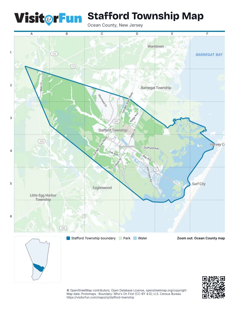
Street index of Stafford Township
Each street on the sheet and the grid squares it crosses.
- Garden State ParkwayD2, C3, D3, C4
- GSP Northbound entrance rampC3
- Main StreetA2, D3, D4
- South Main StreetD3, C4, D4, C5
- Manahawkin Bay BridgeE5
- Warren Grove Whiting RoadA2
- West Bay AvenueD4
- Barnegat RoadC3
- Warren Grove RoadA2
- Recovery RoadC3
- Mill Creek RoadD4, D5, E5
- East Bay AvenueD4, E4, E5
- Stafford AvenueD4, E4
- Cedar Run Dock RoadD4, D5
- Nautilus DriveC2, C3
- Lighthouse DriveC2, D2, C3
- Hilliard BoulevardD4
- Jennings RoadD4, D5
- McKinley AvenueC4, D4
- Morris BoulevardD5, E5
- Old Manahawkin Cedar Bridge RoadD3, D4
- Jennifer LaneD5, E5
- Stafford Park BoulevardC3
- Mayetta Landing RoadC4, C5, D5
- Doc Cramer BoulevardC4
- Jane DriveD4, D5
- Martin Truex Junior BoulevardC4
- Marsha DriveD5, E5
- Charles BoulevardD4, D5
- General Grier BoulevardC4, D4
- Captain Randolph BoulevardC4, D4
- Jonathan DriveD5
- East/West ConnectorC4
- Landings WayC4
- Junction RoadD5
- Mermaid DriveC2, C3
- Breakers DriveC2, C3
- Buccaneer LaneC2, D2, C3, D3
- Ridge AvenueD3
- Newell AvenueD4, D5
- Atlantis AvenueC2, C3
- Oak AvenueC4, D4
- Atlantic Hills BoulevardC2
- Beach AvenueD4
- Neptune DriveC2
- Beachview AvenueD3
- Beach Haven West BoulevardD4, D5, E5
- Timberlake DriveD4
- Leeward RoadC2, C3
- Windlass DriveC3
- Oak Ridge LaneC4, D4
- Treasure AvenueC3
- Parrys LaneC4
- Campbell BoulevardC3
- Barnacle DriveC3
- Compass RoadC2
- Forecastle AvenueC3
- Sextant RoadC2, C3
- Anchor AvenueC3
- Silo RoadD3
- Parker StreetD4
- Outboard AvenueC3
- Mary Bell RoadD3
- Pancoast RoadA2, B2
- Haywood RoadC3
- Oxycocus RoadD4
- Paul BoulevardD5, E5
- Wave RoadC2, C3
- Topside RoadC2
- Ashburn AvenueC3
- Lamson RoadC4
- Bishop LaneC4
- Mizzen AvenueC3
- Rudder AvenueC3
- William Cook BoulevardD4, D5
- Kristine AvenueD3
- North Lakeshore DriveD4
- Littleworth Mill RoadD3, D4
- Privateer RoadC3
- Yeoman RoadC3
- Prospect AvenueD3
- Commodore RoadC2
- Pirate LaneC2, D2, D3
- Bradshaw DriveC3
- Golf View DriveC3, D3
- Riptide AvenueC3
- Middle RoadA2
- Corliss WayC3
- Whispering Oak LaneC3
- East Mallard DriveE4, E5
- Coral LaneC2, D2, C3
- Float AvenueC3
- Flipper AvenueC3
- Catherine LaneD5
- Jeremy LaneD5
- Torpedo RoadC2
- Cutter LaneC2
- Bulkhead AvenueC3
- Cervetto RoadA2
- White Cap AvenueC3
- Lakeview DriveD2
- Sycamore RoadC2
- Division StreetD4
- Shark LaneC2, D2
- Saint Meena AvenueD3
- Bennet LaneC3
- Honeysuckle DriveC2
- Rodeo DriveC5
- Steamer AvenueC3
- Walter BoulevardD5, E5
- Sandy CircleC3
- Beach LaneC3
- Canal AvenueC3
- Center StreetD4
- Peter RoadD5
- Cutlass AvenueC3
- Matey AvenueC3
- Matilda DriveD5
- West Mallard DriveE4, E5
- Inlet AvenueC3
- Bowline RoadC2, C3
- Bernard DriveD5
- Stage RoadC2
- Beacon AvenueC3
- Liberty AvenueC3
- Southard DriveD5
- Cranberry RoadC2
- Captain RoadC2
- Polly Pod RoadC4
- Barracuda RoadC2
- Ranch BoulevardD3
- Dolphin RoadC3
- Ethan BoulevardC4
- Lookout DriveC2
- South Lakeshore DriveD4
- Vessel LaneC3
- Stowaway RoadC2
- Tackle AvenueC3
- Eileen LaneD5
- Bowsprit RoadC2, C3
- Sailor DriveC3
- Holly AvenueC4
- Bruce DriveD5
- Fathom AvenueC3
- Crows Nest RoadC2
- Parkside LaneC4
- Skipper RoadC2
- Schooner RoadC2
- Mulberry DriveC2
- Mariner LaneC3
- Pine Grove AvenueC4, D4
- Clearwater AvenueC3
- Gunwale RoadC2, C3
- Katydid DriveC4
- Melanie WayC3, C4
- Quadrant RoadC2, C3
- Rodman DriveD4
- Academy LaneC2, C3
- Paramount Escapes DriveC2
- Fort Lee DriveC4
- Poplar StreetC4
- Gaff RoadC2, C3
- Albatross AvenueC3
- Windward DriveD4
- Topsail LaneC3
- Yeomen RoadC2
- Sloop RoadC2
- Brigantine RoadC2
- Grays RoadA2, B2
- Popper StreetD3
- Shore AvenueC3
- Serpent LaneC2, C3
- Florence LaneD5
- Longwood DriveC2
- Cruise RoadC2
- Dogwood RoadC2
- Hawser AvenueC3
- Lakewood AvenueD4
- Highlands RoadC4
- Circle DriveE5
- Crew LaneC3
- Tiller AvenueC3
- Simm Place RoadA2
- Mary Alice RoadD5
- Clipper RoadC2
- Albert DriveD5
- Highland DriveC2
- Outrigger LaneC2, C3
- Gregg DriveD5
- Bluejacket AvenueC3
- Oak StreetD4
- Lyle AvenueD4
- Stormy RoadC2
- Jeteemale DriveD4, D5
- Galley AvenueC3
- Magnolia RoadC2
- Beverly LaneD5
- Driftwood AvenueC3
- Coast AvenueC3
- Lawrence DriveD4, D5
- Seashelle AvenueC3
- Equinox RoadC2
- Harry DriveD5
- Mooring RoadC2
- Bosun AvenueC3
- Patty LaneD4, D5
- Chestnut DriveD4
- Ripple AvenueC3
- Lafayette DriveD4
- Midship AvenueC3
- Joshua DriveE5
- Spinnaker AvenueC3
- Morton DriveD5
- Pulley AvenueC3
- Junction DriveC4
- Arthur DriveD5
- Country RoadD3
- Sylvia LaneD5
- Washington AvenueC3, C4
- Manahawkin CommonsC3, C4
- Whippoorwill LaneC4
- Benjamin BoulevardE5
- Inboard AvenueC3
- Manor DriveD4
- Hudson StreetD4
- Reel AvenueC3
- Middie LaneC2, C3
- Cypress LaneC4
- Heron StreetE5
- David DriveD5
- Indian RoadD4
- Pennsylvania AvenueD4
- Summerhill DriveC2
- Cornell DriveD4
- Warren CourtD3
- Seaspray RoadC2
- Stone Hill RoadD3
- Capstan AvenueC3
- Pfeiffer AvenueD4
- Evelyn DriveD5
- Glenn DriveD5
- Hazelton CourtD3
- Voyager LaneC2
- Crystal Oak LaneC4
- Lynn Ann LaneD5
- Micaja's RoadA2
- Janal WayD3
- Cedar LaneD3, C5
- Lehigh AvenueD4
- Jeri Anne DriveE5
- Island Breeze CourtD4
- Myrtle DriveD5, E5
- Phyllis LaneD5
- Deer Lake CourtD4
- Fairview TerraceD3
- Delaware AvenueD4
- Jiran RoadC4
- Howard DriveE5
- Marlin RoadC3
- Osprey AvenueC3
- Stocum RoadC4
- Baltimore AvenueD4
- Royal Oak CourtC4
- Aaron DriveE5
- Mark DriveE5
- Weaver DriveD5, E5
- Claudia LaneD5
- Navy LaneC2
- Shoveler LaneD4
- Henry DriveE5
- Willard DriveE5
- Ridgeway AvenueD4
- Grassy Hollow RoadD4
- Hampton RoadC2
- Rona LaneD5
- Frank DriveD5, E5
- Linda RoadD5
- Deerfield DriveC2
- Allen LaneC4, C5
- Ross CourtD3
- Anita DriveD5
- Bonita LaneD2
- Walt Brummer RoadD4
- Andrew DriveD5
- Eno RoadC4
- Fir RoadC2
- Gangway LaneC3
- Jennie DriveE5
- Lally LaneC4
- Sugar Hill RoadD3
- Steven DriveE5
- Aspen LaneD4
- Bryce LaneC4
- Tahoe LaneD4
- Avenue AE5
- Hatch LaneC3
- Ahoy RoadC2
- Harold LaneD5
- Lanyard RoadC2
- Canoe LaneD3
Places on the map
- A. Paul King County Park
- Beach Haven West
- BJ's Wholesale Club
- Bonnet Island
- Costco
- Doc Cramer Disc Golf Course
- Doc Cramer Fields
- Greenwood Cemetery
- Holiday Lake
- Lighthouse Park
- Lowe's
- Manahawkin
- Manahawkin Bay
- Manahawkin Lake
- Manahawkin Lake Park
- Manahawkin Wildlife Management Area
- Mill Creek Commons
- Mill Creek Park
- Nautilus Park
- Ocean Acres
- Ocean Acres Country Club
- Ocean Acres Elementary School
- Ocean Acres Lake Park
- Oxycocus Elementary School
- Sierra Mines
- Soaring Sun Seaplane Base
- Southern Ocean Medical Center
- Southern Regional High School
- Southern Regional Middle School
- Stafford Municipal Complex
- Stafford Park Mall
- Stafford Square
- Stafford Township Library
- Stafford Township Public Schools
- Target
- The Home Depot
- Thorofare Island
- Turtle Cove
- Walmart
- Westecunk Pine Plains
Next to Stafford Township
- Barnegat Township map
- Eagleswood
- Harvey Cedars
- Little Egg Harbor Township map
- Ship Bottom
- Surf City
- Waretown
© OpenStreetMap contributors, Open Database License, openstreetmap.org/copyright · Map data: Protomaps · Boundary: Who's On First (CC-BY 4.0); U.S. Census Bureau















