

New Jersey map
Millville map
About 27,838 people live here (Census Bureau, 2024 estimate). The sheet's index lists 300 streets; Veterans Memorial Highway, West Main Street and East Main Street cross the most grid squares. Things to do inside the boundary: Millville Army Air Field Museum and WheatonArts.
Open the map (PDF, US Letter)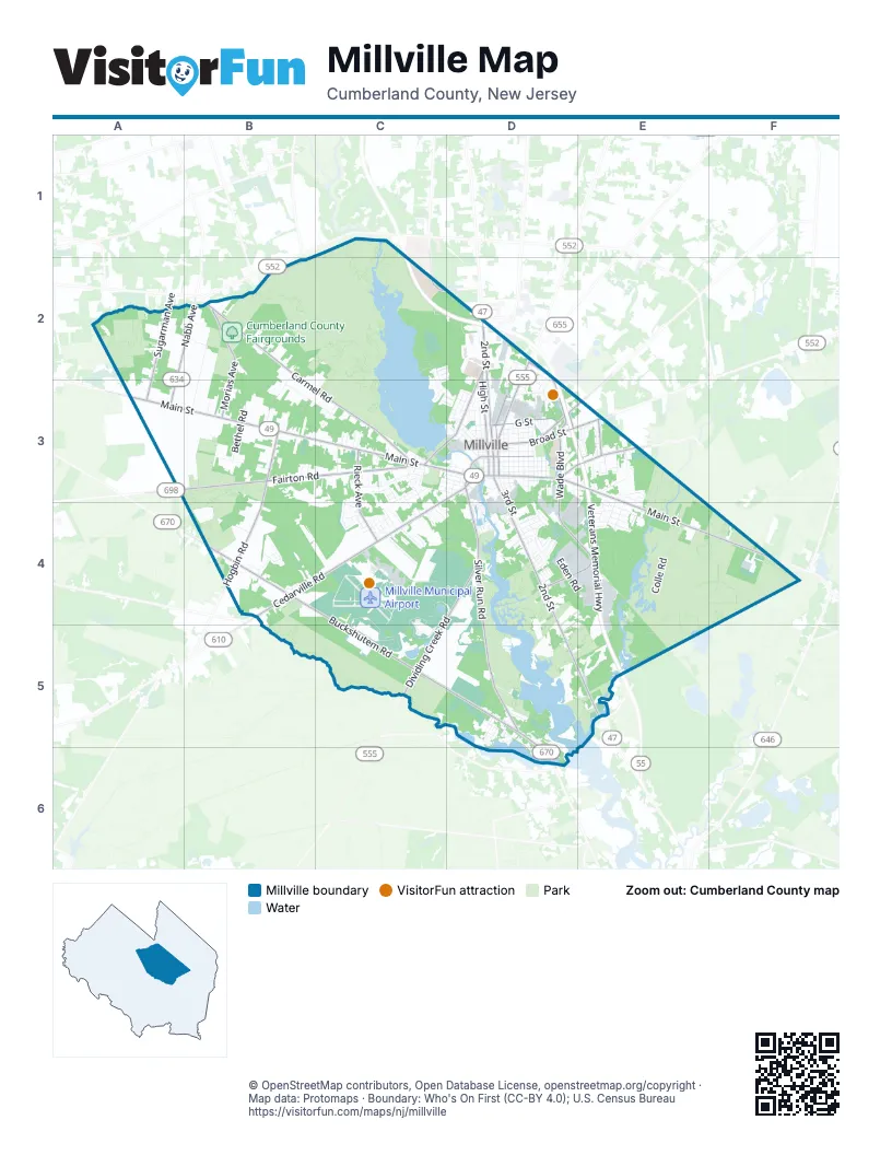
Street index of Millville
Each street on the sheet and the grid squares it crosses.
- Veterans Memorial HighwayC1, C2, D2, D3, E3, E4, E5
- West Main StreetA3, B3, C3, D3
- East Main StreetD3, E3, E4, F4
- South 2nd StreetD3, D4, D5, E5
- North 2nd StreetD2, D3
- East Broad StreetD3, E3
- Wheaton AvenueD2, D3
- North 3rd StreetD3
- Bridgeton Millville PikeA3
- East Mays Landing RoadE3
- West Buckshutem RoadB4, C4, C5, D5
- Silver Run RoadD3, D4, D5
- Fairton RoadA3, B3, C3
- Cedarville RoadB4, C4
- Dividing Creek RoadC4, D4, C5
- North Wade BoulevardD3
- Nabb AvenueA2, B2, A3
- South Wade BoulevardD3, D4, E4
- Cedar StreetC3, D3, C4
- G StreetD3
- East Vine StreetD3
- East Buckshutem RoadD5, D6
- Orange StreetD4, E4
- Wade BoulevardD2, D3
- Fairton Millville RoadA3
- North Brandriff AvenueD3
- South Race StreetD3
- South Brandriff AvenueD3
- Beech StreetC3
- West Vine StreetD3
- Buckshutem RoadD6
- Carmel RoadB2, B3, C3
- Hogbin RoadB3, B4
- North High StreetD2, D3
- Morias AvenueB2, B3
- Sharp StreetD2, C3, D3
- Sugarman AvenueA2, A3
- Rieck AvenueC3, C4
- Hance Bridge RoadD3, E3
- Newcombtown RoadD3, E3
- Crest AvenueE3
- College DriveC2
- Leaming Mill RoadE3
- ThunderboltC4, C5
- LightningC4, C5
- Bogden BoulevardC4, D4
- Colle RoadE4
- North 10th StreetD3
- Kart TrackC4, C5
- Buck StreetD3
- South 3rd StreetD3, D4
- Rosen AvenueB2, B3
- Shewchenko AvenueB3, C3
- Pleasant DriveC3
- East Pine StreetD3
- Sassafras StreetD3
- Smith RoadB2, B3
- East Mulberry StreetD3
- Eden RoadD4, E4
- Burns RoadE3
- Glenside RoadC2, C3, D3
- Whitaker AvenueD2, D3, E3
- Esibill AvenueC3, C4
- North 9th StreetD3
- Millville AvenueB3
- North 8th StreetD3
- North 7th StreetD3
- North 5th StreetD3
- East Oak StreetD3
- North 4th StreetD3
- Louis DriveD4
- Menantico AvenueD4
- Dock StreetD3
- Sunset DriveD3
- Bluebird LaneD2
- Shamrock LaneE4
- North 6th StreetD3
- Porreca DriveC4
- Ettie DriveE3
- F StreetD3
- Hampton RoadB4
- Pit LaneC5
- E StreetD3
- Northeast Lakeshore DriveD5, D6
- Southwest Lakeshore DriveD5
- Carlton AvenueC3, C4
- Tomasello DriveC4
- South Bethel RoadB3
- Gorton RoadE4
- Cottage StreetB4
- Columbia AvenueD3
- Fulton StreetC3, D3
- Mistletoe LaneE4
- Shar Lane BoulevardD4
- Manor AvenueE3
- Woodland DriveD5
- Churchill DriveC4
- North Ladow AvenueD2
- Buttonwood LaneE4
- Ireland AvenueC3, D3
- Geissenger AvenueE3
- Clover LaneE4
- Oak Dale DriveD3
- D StreetD3
- Crescent BoulevardE3, E4
- South 15th StreetD3, D4
- Glasstown RoadD3
- Cornwall AvenueC4
- Earle AvenueC3, C4
- Maurice StreetD3
- Hook RoadB3
- Court BoulevardE4
- Coombs RoadD3
- King AvenueC3
- Briar DriveC3, C4
- Lloyd TerraceC3, C4
- Burcham LaneD5, E5
- Kates BoulevardD3, D4
- Whitall AvenueD4
- Fowser RoadD4
- Reese RoadE4
- Sheldon AvenueC3
- Adams DriveD4
- Cedarbrook AvenueC3, C4
- West Foundry StreetD3
- Peach DriveC4
- Howard StreetC3, D3
- Jfk BoulevardD4
- Ware AvenueD3
- Hillside AvenueC4, D4
- Main DriveD5
- Emily DriveC4
- Vine RoadD5
- Riverside DriveD3
- Wharton StreetB4
- West Race StreetC3, D3
- Deerpath RoadC2
- Westwood TerraceC3
- Village DriveD3
- Kimberly DriveE3
- Rhonda DriveC4
- Smith StreetD3
- West McNeal StreetD3
- Homestead DriveD3
- Mallard StreetC2, C3
- Richard DriveD4
- Rosewood RoadD5
- Val LaneC4
- Cedar LaneC4
- Debbie LaneC3, C4
- Church StreetD3
- Old Union RoadD2
- Geissel DriveC4
- T-Fal DriveD4, E4
- Archer StreetD3
- North StreetD3
- Southeast Lakeshore DriveD5, D6
- Cooper StreetC3
- Brian AvenueD4
- Valatia AvenueD4
- South 10th StreetD3
- Lisa Marie TerraceC3
- North Bethel RoadB3
- Fairstand RoadB2
- Quail DriveC3, D3
- North 12th StreetD3
- Roselle DriveC3
- Shelburn RoadE3
- Chestnut StreetC3
- River DriveD5
- Caloris AvenueD3
- North 11th StreetD3
- West Green StreetD3
- Maple StreetC3, D3
- Mallard LaneC2, D2
- Dove DriveC3, D3
- Ladow AvenueD2
- Beebe's Landing RoadC2
- Cecile DriveE3
- Henderson AvenueD4
- Dorset AvenueC4
- North 13th StreetD3
- Mill Village DriveD3
- Robin TerraceD4
- McCafferty BoulevardC4
- Sloans DriveD5, E5
- South 4th StreetD3
- Circle DriveD3, E3
- Peterson StreetC4
- Pineland AvenueD3
- Cedarview CourtD2, D3
- Miller AvenueD2, D3
- Sycamore RoadD5
- Rosalie DriveA2
- Goldfinch LaneC2, D2
- Cherry StreetC3
- Fortune LaneB4
- East Forest Glen DriveE3, E4
- Pershing AvenueD3
- Inglewood AvenueB3
- Fairfield AvenueC4
- Willow RoadD5
- Surry AvenueC4
- Poplar AvenueD4
- Wildwood AvenueC4
- Barbara TerraceD3
- Marlyn TerraceC3
- Brittany LaneD5
- Ginger AvenueC3
- West Harrison AvenueD3
- Holly DriveE3
- University RoadD5
- Florence AvenueD3
- Tulip RoadD5
- Kauffman AvenueB2
- South 5th StreetD3
- Hillcrest AvenueC3
- Packard DriveC4
- Hazel BoulevardE4
- South Ladow AvenueD2
- Hawthorn RoadD5
- Peek AvenueD4
- Robin RoadC3
- Deborah DriveD5
- Easy StreetD2, D3
- Megan DriveC4
- Starling DriveC3, D3
- Chickadee LaneC2, D2, C3
- Caroline LaneE3
- Pineview TerraceD3
- Parkside DriveD3
- Lance CourtC4
- Valley AvenueD3
- Coventry WayD3
- Spencer PlaceE3
- Leonard DriveD4
- Roosevelt DriveD4
- Phyllis DriveB3
- Lafayette StreetD4
- Sandy LaneB3
- Washington AvenueD3
- West Broad StreetD3
- South 9th StreetD3
- Hemlock DriveD5
- Brandy RidgeE3
- Union Lake RoadD3
- Woodland AvenueD3
- Cemetery access roadB2
- North Wedgewood CourtE3, E4
- Cleveland DriveD3, D4
- Bel Aire LaneC3
- Oakland AvenueD3
- Alex DriveC4
- Garrison AvenueD3
- South Spruce StreetC3
- Sixsmith StreetD4
- L StreetD3
- Arlington AvenueC3, D3
- Doris AvenueD2
- Fernwood DriveD3
- Irene StreetC3
- M StreetD3
- Walnut RoadD5
- Brookdale TerraceD4
- Walker StreetB4
- Dewberry AvenueA2
- LIbety DriveD4
- Overbrook AvenueD3
- South Park AvenueD3
- Wellington PlaceE4
- Arnold DriveD3
- Columbine AvenueD4
- West Powell StreetD3
- Queen RoadD5
- Brenda TerraceC4
- City Park DriveD3
- Fox Cove DriveC3
- Holly Hills CourtD3
- Forest DriveD3
- Lilac StreetD4
- Marc DriveC3
- Stratton AvenueD4
- Railroad AvenueD3
- Redwood AvenueC4
- West Wedgewood CourtE3, E4
- 14th StreetD3
- Malone StreetC4
- Dayle DriveE3
- Airwork StreetC4
- Birch RoadD5, D6
- Cedar RoadD5, D6
- Jason DriveC3, C4
- Linda LaneE3
- Turtle CourtD5
- Shore RoadD5
- Sterling PlaceC3
- South Pearl StreetC3
- Aspen RoadD5, D6
- Driskill StreetC4
- Holly Berry LaneD4
Things to do on the Millville map
Places on the map
- Action Hyundai
- Advance Auto Parts
- Affordable Tire of Millville
- All Saints
- Beaver Lake
- Building 23 – Henry E. Wyble Historic Research Library & Education Center
- Carmel Cemetery
- Cedarville Road Complex
- Choppers Hatchet House Outdoors
- Clark's Liquor Store
- Community Church
- Corson Park
- Cumberland County Fairgrounds
- Cumberland County Open Space
- CVS Pharmacy
- Distance Learning Center/ Library
- Dollar General
- Greenwood Cemetery
- Hankins Pond
- Harold N. Peek Preserve
- James Ford Park
- Joe Buck Park
- Kart Track
- Lakeside Middle School
- Lightning
- Memorial High School
- Menantico Creek Preserve
- Menantico Ponds
- Menantico Ponds Wildlife Management Area
- Millville Municipal Airport
- Millville Public Library
- Mount Pleasant Cemetery
- NJ Field of Dreams Trails Park
- Rowan College of South Jersey
- Sharp Street Park
- Thunderbolt
- Union Lake
- Union Lake Wildlife Management Area
- Waltman Park
- WheatonArts
© OpenStreetMap contributors, Open Database License, openstreetmap.org/copyright · Map data: Protomaps · Boundary: Who's On First (CC-BY 4.0); U.S. Census Bureau















