

New Jersey map
Vineland map
About 62,070 people live here (Census Bureau, 2024 estimate). The sheet's index lists 300 streets; Veterans Memorial Highway, Landis Avenue and South Lincoln Avenue cross the most grid squares. Things to do inside the boundary: Cumberland Mall.
Open the map (PDF, US Letter)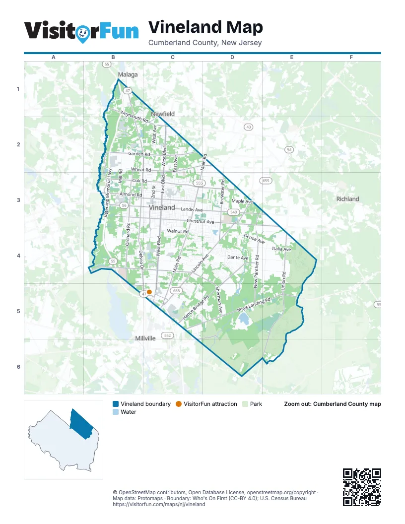
Street index of Vineland
Each street on the sheet and the grid squares it crosses.
- Veterans Memorial HighwayB1, B2, B3, B4, C5
- Landis AvenueB3, C3, D3, E3
- South Lincoln AvenueD3, C4, D4, C5
- North Delsea DriveB1, B2, C2, B3
- South Main RoadC3, C4, C5
- South Delsea DriveB3, B4, C4, C5
- Mays Landing RoadD5, E5
- North Main RoadC2, D2, C3
- East Mays Landing RoadC5, D5
- North 2nd StreetC3, C5
- Burns AvenueC5
- North Lincoln AvenueD3
- Hennis RoadC5
- Wheaton AvenueC5
- Lincoln AvenueD3, C5
- Millville-Mays Landing RoadE5
- Delsea DriveB1
- Main RoadD2
- Union RoadE4, E5, E6
- South West BoulevardC3, C4, C5
- East Sherman AvenueC4, D4, D5
- North West BoulevardC2, C3
- South East BoulevardC3, C4, C5
- North East BoulevardC2, C3
- West Sherman AvenueB4, C4
- West Garden RoadB2, C2
- Weymouth RoadB1, B2, C2
- Almond RoadB3
- North Brewster RoadD3
- East Park AvenueC3
- South Brewster RoadD3, D4
- West Park AvenueB3, C3
- West Weymouth RoadC2
- Fenimore StreetC3
- East Weymouth RoadC2
- West BoulevardC2
- East Chestnut AvenueC3, D3, E3
- Hance Bridge RoadD4, C5, D5
- New Panther RoadD3, D4, D5
- East Oak RoadC3, D3
- South Orchard RoadB3, B4
- West Oak RoadB3, C3
- Maurice River ParkwayB2, B3
- West Chestnut AvenueB3, C3
- East Wheat RoadC2, D2
- West Wheat RoadB2, C2
- North Orchard RoadB2, B3
- East Garden RoadC2
- South West AvenueC3, C4
- College DriveB4, B5, C5
- Leaming Mill RoadD5, C6, D6
- Wheat RoadC2, D2
- Salem AvenueC1, C2
- Quigley AvenueB3
- Oak RoadD3
- North Mill RoadB1, B2, B3
- North West AvenueC2, C3
- Dante AvenueD4, E4
- North East AvenueC2, C3
- Maple AvenueC3, D3
- Cornucopia AvenueE4, E5
- Genoa AvenueD4, E4
- Italia AvenueD4, E4
- South East AvenueC3, C4
- South Spring RoadD3, D4
- Pennsylvania AvenueC5, D5
- Magnolia RoadC4, D4
- East Elmer RoadC4, D4
- East Walnut RoadC4, D4
- Columbia AvenueB1, C1, C3
- Sheridan AvenueC5
- West Walnut RoadB3, B4, C4
- West Forest Grove RoadB2, C2
- Washington AvenueC3, D3
- East Grant AvenueC4
- Venezia AvenueD4
- North Valley AvenueC2, C3
- Ascher RoadE4, D5, E5
- South Mill RoadB3, B4
- Palermo AvenueD4
- Piacenzia AvenueD4, E4
- South Brookfield StreetD4
- South State StreetC3, C4
- South 7th StreetC3, C4
- Trento AvenueD4, E4
- West Arbor AvenueB2, C2
- East Butler AvenueC4
- Vine RoadC3, D3
- Oxford StreetC3
- Wood StreetC3
- East Forest Grove RoadC2
- Roosevelt BoulevardC4, D4
- South Myrtle StreetC3, C4
- South Valley AvenueC3, C4
- Dougnty's Tavern RoadE5
- Peach StreetC3
- Elm RoadB4
- New Pear StreetC3
- South 8th StreetC3, C4
- South 3rd StreetC3, C4
- Blueberry LaneC5, D5
- West Montrose StreetB3, C3
- South 6th StreetC3, C4
- East Almond StreetC3
- West Almond StreetB3, C3
- Lake RoadB1, C1
- Foster AvenueB4, C4
- Holmes AvenueC3, C4
- North 6th StreetC3
- West Elmer RoadB4, C4
- Menantico RoadD4
- North 3rd StreetC3
- Industrial WayB2
- 2nd StreetB3, C3
- Swan DriveD4
- Highland AvenueD3, D4
- Cambridge StreetC3
- Pear StreetC3
- Laurel StreetC3
- Fairmount AvenueC3
- Woodcrest DriveC3
- West Grant AvenueB4, C4
- Gallagher DriveB2
- North 4th StreetC3
- Birch StreetB1, C3
- Strawberry AvenueC2
- Covered Bridge RoadC5
- Little Flower DriveC2
- Franklin DriveD4
- London LaneD4
- Summit StreetC3
- Whispering Woods WayD4
- Snyder AvenueC5, C6
- Garrison RoadB4
- West Elmer StreetB3, C3
- Garry AvenueC4
- Rogers AvenueC4
- West Butler AvenueB4, C4
- Barry DriveD4
- Allen AvenueC3, C4
- Florence AvenueC3
- Utopia LaneD4
- East Cherry StreetC3
- Fairview DriveC5, D5
- Hendee RoadC3
- Demarco DriveB2
- Sharp RoadC3
- Greenwillows DriveC4, D4
- Sunset AvenueB3
- Harding RoadC4
- Venus DriveB3
- Woodlawn AvenueB3
- Mayfair StreetC3
- Timberbrook DriveC3
- Arrowhead TrailC4, D4
- Elmer StreetC3
- West Cherry StreetC3
- West Grape StreetC3
- Plum StreetC3
- Bradford DriveB3, B4
- North Spring RoadD3
- Old Union RoadE4, C5, E5
- Becker DriveD3
- South 2nd StreetC3
- South 4th StreetC3
- BroadwayC3
- Howard StreetC3
- Evelyn AvenueC3
- Fruit StreetD4
- Old Forest RoadC2
- East Grape StreetC3
- Mount Vernon StreetC3
- East Plum StreetC3
- East Quince StreetC3
- West Quince StreetC3
- Linden BoulevardD4
- Venturi LaneD4
- Old Lake RoadB1
- Quail StreetD4
- Cherokee LaneC4
- Park DriveC3
- Friendship StreetC2
- Wynnewood DriveD4
- Virginia LaneC5
- Crystal AvenueC3
- Brown RoadB1
- Junior DriveC2, D4
- Bortle AvenueC3
- Yelkca StreetC3
- Beacon AvenueC4
- Linda LaneC3
- Sanford DriveD4
- Arcadia PlaceC3
- Broadlawn TerraceC3
- Chimes TerraceB3
- Juniper StreetD5
- North Brookfield StreetD3
- Riviera BoulevardD4
- Dolly DriveD4
- Clover AvenueC4
- Athens WayD4
- McClain DriveD4
- Blossom LaneC5, D5
- Madison AvenueD3, D4
- Phillip StreetC2, D2
- Independence RoadE4
- North 8th StreetC3
- North 7th StreetC3
- North Myrtle StreetC3
- South Pear StreetC3
- Brunetta DriveC4
- Coronado DriveB4
- Nathan LaneC5
- Civil War RoadC4, D4
- Monroe AvenueD3, D4
- Doren TerraceB3
- Riverside DriveB3
- Hadsell AvenueC3
- Bernard RoadB1, C1
- Hollyhock DriveC2
- Brookhaven DriveD4
- Spruce StreetB1, C3
- Dennis LaneC5
- Cypress DriveC3
- Medina StreetD4
- Willow DriveB1, B2
- Lakeside BoulevardC2
- Axtell AvenueC4
- Country Bridge RoadC5
- Elm StreetB1, C5, D5
- Redwood DriveD4
- John StreetC2
- Queens RoadD4
- Jackson DriveB3
- West Korff DriveB4
- Perna LaneC4
- Prospect AvenueC2
- Charles StreetB3
- Hendricks RoadC4
- Fiocchi DriveC2, C3
- East Montrose StreetC3
- Glenn TerraceC3
- Longwood DriveC3, C4
- Peach Tree LaneC5, D5
- Avon PlaceC3
- Pine StreetC3
- Alps PlaceD3
- Fela DriveC5
- Sherwood DriveD4
- Conley DriveD4
- Oak LaneC3
- Burnt Mill DriveB2
- Robert DriveB1
- Division StreetC2, C3
- Livia LaneC3
- Paterson DriveD4
- Wallace StreetB3
- Wisteria AvenueB1, C4
- Graiffs WayD4
- D'Shibe TerraceC3
- 3rd St TerraceC3
- Rome RoadD4
- Yale TerraceC3
- Carpy AvenueD3
- Embassy TerraceC3
- McMahan DriveC4
- Delmar AvenueB4
- Bella Rosa CourtD4
- Westmont LaneC3
- Redcrest StreetD3
- Tower LaneC3
- High Ridge RoadC5, C6
- Sarah PlaceC3
- Warren DriveB3
- Iris AvenueC4
- Mart AvenueD4
- Musterel LaneD4
- Vassar PlaceC3
- Dauphin RoadC3, C4
- Grandview AvenueC3
- Robin RoadB1
- Denise DriveC2
- Stoney Bridge RoadC5
- Grubb RoadB1
- Sawyer AvenueC3
- Wayne AvenueC3
- Tuttlegrove RoadD4
- Roberts BoulevardC3
- Old Panther RoadD3, D4
- Elmwood AvenueC3
- Northwood DriveC3
- Victory AvenueC3
- Russell AvenueC5
- Carlisle DriveB3
- Cherry LaneC5
- Evergreen AvenueB1, C3
- Hubbard LaneB2
- Knoll DriveD3
- Noel DriveB1
- Neptune TerraceB3
Things to do on the Vineland map
Places on the map
- Acme
- Albert Giampietro Memorial Park
- Aldi
- Applebee's
- Bank of America
- Bishop Schad Regional School
- Cannabist
- Chick-fil-A
- Chipotle
- Cumberland County Community Based Outpatient Clinic
- Cumberland Mall
- Cunningham Academy
- CVS Pharmacy
- Days Inn by Wyndham Vineland
- Delsea Drive-in
- Divine Mercy Parish
- Encompass Health
- Free Spirit Airport
- Inspira Medical Center Vineland
- Joseph E. Romano Sports Complex
- Kroelinger Airport
- Landis Park
- Lincoln Plaza
- Memorial Pond
- Menantico Lake
- NEP Pond1
- NEP_Pond4
- Oak Hill Cemetery
- Pineland Learning Center
- Sacred Heart Cemetery
- Siloam Cemetery
- South Vineland Park
- The UPS Store
- Trout National
- Upper Manumuskin River Preserve
- Vineland Developmental Center
- Vineland Public Library
- Vineland Sehior High School North
- Walmart Supercenter
- Willow Oak Natural Area
Next to Vineland
- Malaga
- Millville map
- Newfield
- Richland
© OpenStreetMap contributors, Open Database License, openstreetmap.org/copyright · Map data: Protomaps · Boundary: Who's On First (CC-BY 4.0); U.S. Census Bureau















