

New Mexico map
Cibola County map
About 26,686 people live here (Census Bureau, 2024 estimate). The sheet's index lists 300 streets; Ice Caves Road, Pine Hill Highway and (two track trail) cross the most grid squares. Things to do inside the boundary: Acoma Pueblo (Sky City), El Morro National Monument and Ice Cave and Bandera Volcano.
Open the map (PDF, US Letter)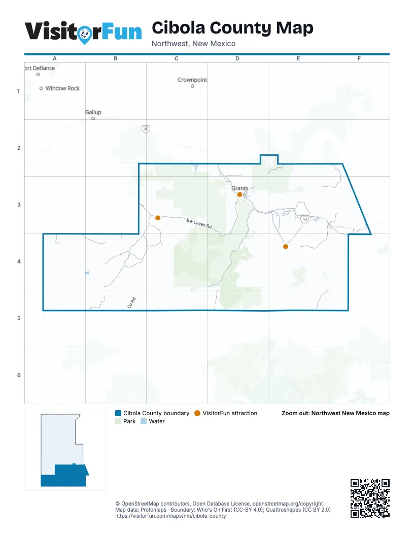
Street index of Cibola County
Each street on the sheet and the grid squares it crosses.
- Historic Route 66D2, D3, E3
- Ice Caves RoadB3, C3, D3, D4
- El Malpais RoadD3, D4
- San Rafael RoadD3
- East Santa Fe AvenueD3
- State Road 6F3, F4
- Horizon BoulevardD3
- San Rafel RoadD4
- Pine Hill HighwayB3, C3, B4, C4
- Indian Service Route 22E3, E4
- Indian Service Route 30E3
- Lobo Canyon RoadD3
- Roosevelt AvenueD3
- Veterans Memorial RoadE3
- 1st StreetD3
- 2nd StreetD3
- Old Route 66 RoadE3
- West Roosevelt AvenueD3
- San Mateo RoadD2
- Indian Service Rt 22E3
- Candy Kitchen RoadB4
- County Road 1F2, E3, F3
- Indian Service Rt 491E3, F3, E4
- County Road 35 AB5
- Forest Svc 239 RoadE2
- Cerro Alto RoadC3, C4
- County RoadE4, E5
- Pine Hill Highway - BIA 125B4
- Pine Hill RoadB4
- Indian Service Route 38E3, A4, E4
- Indian Service Rt 522F3
- Old Highway 66F3, F4
- Indian Service Route 8A4, B4
- Indian Service Route 24E3
- Indian Service Road 34E3
- Atarque Crossing - BIA144B4
- Yucca Village RoadC4
- Indian Service Rt 47E3
- Indian Service Route 32E3
- County Road 63D2
- Garcia Ranch Rd. - BIA 128B4
- Pie Town RoadD5
- Ojo Caliente RoadA4
- State Highway 612C2
- Indian Service Rt 38E4
- Sakelares BoulevardD3
- Canoncito School RoadF3
- George Hanosh BoulevardD3
- Co Road 8E3
- Veterans BoulevardE3
- Indian Service Route 33D3
- Washington AvenueD3
- Indian Service Rt 50E3
- Main StreetD2, D3
- Miller Loop - BIA 133B3
- Mesa BoulevardD3
- Post Office Flats RoadD3
- Pine Hill Rd. - BIA 128B4
- Indian Service Route 36E3
- Knife Hill Canyon RoadB4
- Road 41D5
- San Jose DriveD3
- Indian Service Rt 46E3
- Old Route 66E3, F3
- Sparrow Hawk RoadF3
- Nimitz DriveD3
- Cubero LoopE3
- Jefferson AvenueD3
- Warren StreetD3
- Old 66E3
- Monument DriveC3
- Deer Dancer RoadE3
- Rio San Jose RoadE3
- Roadrunner LoopE3
- Indian Service Rt 27E3
- Garcia Ranch RoadB4
- Indian Service Route 503E3
- Acorn RoadE3
- County Road 41D4
- Indian Service Rt 184C4
- Warrior DriveC4
- Balsam StreetD3
- County Road 75E2
- San Mateo Main StreetE2
- Road 124E3
- Indian Service Rt 30E3
- Highway 612C2
- Mount Taylor DriveD3
- Sage AvenueD3
- Indian Service Road 38E4
- Indian Service Route 46E3
- Postal RoadE3
- Gold AvenueD3
- Water Canyon RoadE3
- Los Pinos DriveD3
- Indian Service Rt 143C4
- Anzac RoadD3
- Pia MesaA4
- 5th StreetD3
- Mount Taylor AvenueD3
- El Morro RoadD3
- Paraje RoadE3
- Lee Ranch Commino RoadE2
- Frontage RoadF3
- Indian Service Rt 243E3
- North Breeze StreetD3
- Cattle DriveF3
- Indian Service Rt 36E3
- New Mexico 601B5
- (two track trail)B3, C3, B4, C4
- (driveway)B3, C3, B4, C4
- County Road 42C4, D4
- Indian Service Route 21E4, E5
- Indian Service Route 29E3, D4, E4
- County Road 32A4, B4
- Petaca Pinta RoadE4, F4
- Indian Service Rt 33A4
- Forest Service Road 480C3, D3
- Forest Svc 180 RoadC3, D3
- Forest Service Road 50C3
- County Road 35 DB5
- Indian Service Route 54F4
- Zuni Canyon RoadD3
- Indian Service Rt 541E4, F4
- Indian Service Route 292E3, D4, E4
- Forest Road 400E3
- Co RoadB4, B5
- (private two track trail)C3
- Indian Service Rt 543E4, F4
- Forest Road 50C3
- Indian Service Route 39D4, E4
- Indian Service Rt 521E3, F3
- County Road 42 (cdt hiking trail)C3, C4
- Forest Service Road 425C3, D3
- Mesa Ridge - County Rd. 47C3, C4
- State Route 50C3
- Cerro Alto Rd. - BIA 143C4
- Indian Service Route 382D3, E3
- Forest Svc 193 RoadE2, E3
- Jacobs Well Rd. - BIA 139C4
- Timberlake RoadB3
- Indian Service Rt 211E4
- Indian Service Route 37D4, E4
- Indian Service Rt 212E4
- Vietnam Veteran's RoadE3
- County Road 35 FB5
- Indian Service Rt 40E3
- Red Lake Crossing - BIA 129B4
- Pine Meadow DriveC3
- Forest Svc 544 RoadD2
- County Road 149C3
- Forest Svc 453 RoadE2
- Forest Service Road 548C3
- BNSF Easement RoadD3
- Road 421C3
- Five Gate RoadB4
- Indian Service Rd. - BIA 153B4
- Forest Road 157B2, B3
- Indian Service Rd. - BIA 276B3, C3
- Mount Taylor Ranch RoadE3
- Indian Service Rt 25E3
- Bell RoadD3
- Mesa Ridge - County Rd.47C3
- Ridge RoadB4
- Indian Service Rt 55A4
- Hickory Ln.C3
- Forest RoadB3
- Jubilee TrailB4
- Forest Svc 450 RoadD3
- (closed road)C3
- Flat Stone RoadE3
- Well RoadB4
- Encinal Paguate RoadE3
- Forest Svc 480 RoadC3
- Indian Service Rt 547F4
- Old County RoadB4, B5
- Washington Trail - BIA 4001B4, C4
- Bodean RoadB4
- Red Lake RoadE5
- County Road 29D2
- Terrero Draw Rd. - BIA131B4, C4
- Ralph Card RoadD3
- FR 453BE2
- Indian Service Route 45E3
- Lawerence RoadD3
- Forest Svc 400 RoadE3
- Indian Service Rt 321E3
- Indian Service Rt 544F4
- Indian Service Rt 26E3
- Indian Service Rt 283E3
- Indian Service Route 49E4
- Indian Service Rd. - BIA 189B4
- Goat Hill RoadC4
- Nicoll Lake RoadC3, C4
- Old Blue Water RoadD2
- Canipa RoadE3
- Indian Service Rd. - BIA 141C4
- Moquino Llano RoadE3
- Edgewood Dr.C3
- County Road 35 CB5
- Old Long's Place RoadB4, B5
- Cliff RoadC3
- County Road 35 BB5
- Canada RoadE3
- Ranch Dr.C3
- Coyote CanyonB4
- Sutton Dr.C3
- Village RoadE3
- County Road 49D3
- Indian Service Rt 304E3
- Indian Service Rt 542F3
- Overlook RoadD3
- County Road 8E3
- Betty Ln.C3
- Cheyenne Dr.C3
- Commanche Dr.C3
- Apache Dr.C3
- Fir StreetD2
- Indian Service Rt 545F4
- Lake Front RoadC2
- Stock Yard RoadE3
- Indian Service Rd. - BIA 145C4
- Valley View Rd. - BIA 130B3
- Indian Service Rd. - BIA 5006B4
- Black Mtn. Rd. - BIA 145C4
- Indian Service Rd. - BIA 4018C4
- Elizabeth Bender Road WestE3
- Rockwood RoadB4
- Canyon Rd. - Forest Service Road 157B3
- Merrill RoadC3
- Indian Service Rd. - BIA 227C4
- Ponderosa Dr.C3, C4
- Indian Service Rt 140C4
- Meadow DR.C3
- Pleasant View Dr.C3, C4
- Acequia DriveE3
- Horace Mesa RoadD3
- Indian Service Rt 502E3
- Rocky Ridge Rd. - BIA 135C3
- Pinon StreetD2, D3, E3
- County Road 19D2, D3
- Woodland Rd. - BIA 214C4
- Red Flat RoadD2
- El Morro WayC3
- Middle Reservoir RoadE3
- God's Acre RoadB4
- Indian Service Route 244E3
- Old Windmill RoadB4
- Great White Father RoadB4
- Pork Chop Hill RoadE3
- Indian Service Rt 52F3
- Indian Service Route 2A4
- Hosteen Dziil Dr.B3
- San Jose Loop (Co Rd 13)E3
- New la Joya LoopE3
- Woodland DriveB3
- Mesita RoadF3
- Sandstone Bluff RoadD4
- Country Ln.C3
- Peaceful Dr.C3
- (twotrack trail)C4
- Harry Garcia Rd. - BIA 2010C3
- Rito RoadF3
- Sunflower DriveB3
- Yanabah Valley Rd. - BIA 138B4, C4
- County Road 5E3
- State Route 334E3
- Juniper Run - BIA 136C3
- Elkins RoadD3
- Indian Service Rt 342E3
- County Road 44D4
- Indian Service Route 55E3, A4
- County Road 19AD2, D3
- Mesa EstatesB3, C3
- Vista Hermosa RoadD2
- Enchanted Mesa Trail EastD3
- Red Fox RoadB4
- Indian Service Rd. - BIA 176C4
- Julie Ln.C3
- DeerField Dr.C3, C4
- Hidden Valley DriveE3
- Industrial Parkway LoopE3
- Black Mesa DriveE4
- Lava Ridge Rd. - BIA 126C4
- Hill Crest Dr.C3
- Copper Weed RoadB3
- Homestead RoadB4
- Yucca Hill Rd. - BIA 103C3
- Seama RoadE3
- Indian Service Rt 351E3
- Uranium AvenueD3
- Backwoods RoadB4
- Rock House RoadB4
- Indian Service Rt 35E3
- Spotted Corn RoadB4
- David's Rock RoadB4
- Sierra de Manana DriveB4
- Indian Service Rd. - BIA 99C3
- Thunderbird RoadD3
- Indian Service Rt 44D3
Things to do on the Cibola County map
Places on the map
- (two track trail)
- Acoma Pueblo
- Acomita Lake
- Anzac Village
- Big Tubes Area
- Bluewater Lake
- Bluewater Lake State Park
- Canyons Wilderness Study Area
- Cebolla Wilderness
- Chain of Craters Wilderness Study Area
- Coyote Del Malpais Golf Course
- El Malpais
- El Malpais National Conservation Area
- El Malpais National Monument
- El Malpais Wilderness Study Area
- El Morro National Monument
- Encinal
- Grants
- Grants-Milan Municipal Airport
- Laguna
- Laguna Larga
- Laguna Pueblo
- Lava Falls Area
- Los Pilares
- Mesita
- Milan
- Nicoll Lake
- North Acomita Village
- Paguate
- Paraje
- Petaca Pinta Wilderness Study Area
- Quartz Hill 01 A
- Seama
- Skyline-Ganipa
- Tailings Pond
- Tinaja Gravel Pit
- United Nuclear-Homestake Mill
- Water Canyon Wildlife Management Area
- West Malpais Wilderness
- Zuni Reservation
Next to Cibola County
- Crownpoint
- Fort Defiance
- Gallup map
- Window Rock
© OpenStreetMap contributors, Open Database License, openstreetmap.org/copyright · Map data: Protomaps · Boundary: Who's On First (CC-BY 4.0); Quattroshapes (CC BY 2.0)















