

New Mexico road map
Trail of the Ancients Scenic Byway map
The Trail of the Ancients Scenic Byway has been a National Scenic Byway since 2021, named for its archaeological qualities: about 439 miles in New Mexico. It meets 24 highways, among them I-40, US 64 and US 491. Towns along it: Farmington, Gallup and Grants.
Open the map (PDF, US Letter)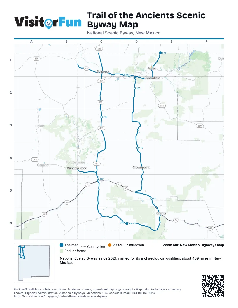
Highways it meets
Each highway it meets and the grid squares where they meet.
- NM 53D6
- I-40E6
- NM 122E6
- NM 615E6
- NM 605E6
- NM 568E6
- NM 606D5
- NM 412D5
- NM 371D5
- US 64D2
- NM 516D2
- US 550D2
- NM 544D2
- NM 173D1
- NM 170D1
- US 491C1
- NM 134C3
- NM 264C4
- NM 608C5
- NM 609C5
- NM 602C5
- NM 118C5
- NM 564C5
- NM 610C5
Towns along the Trail of the Ancients Scenic Byway
In mile order, with the grid square of each.
- El Morro Valleymile 0, D6
- San Rafaelmile 33, E6
- Grantsmile 40, E6
- Milanmile 42, E6
- Golden Acresmile 45, E6
- Bluewater Villagemile 48, E5
- Prewittmile 57, D5
- Thoreaumile 66, D5
- Crownpointmile 88, D4
- Becentimile 102, D4
- Lake Valleymile 122, D3
- Napi Headquartersmile 168, D2
- Totah Vistamile 173, D2
- Farmingtonmile 174, D2
- Crouch Mesamile 178, D2
- Lee Acresmile 179, D2
- West Hammondmile 182, D2
- Bloomfieldmile 187, D2
- Aztecmile 193, D1
- South Rivermile 195, D1
- Center Pointmile 197, D1
- Cedar Hillmile 204, E1
- Upper Fruitlandmile 212, D1
- Kirtlandmile 216, D1
- Fruitlandmile 219, D1
- Nenahnezadmile 221, D1
- Waterflowmile 222, D1
- Shiprockmile 236, C1
- Newcombmile 272, C3
- Sheep Springsmile 282, C3
- Naschittimile 289, C3
- Tohatchimile 307, C4
- Nakaibitomile 313, C4
- Twin Lakesmile 318, C4
- Yah-ta-heymile 324, C4
- Gamercomile 328, C5
- Gallupmile 330, C5
- Catalpa Canyonmile 334, C5
- Vanderwagenmile 350, C5
- Sagarmile 352, C5
- Ramahmile 372, C6
- Rock Springsmile 387, C4
- Black Hatmile 395, C4
- Tse Bonitomile 397, B4
- Beclabitomile 403, B1
Things to do on the Trail of the Ancients Scenic Byway map
© OpenStreetMap contributors, Open Database License, openstreetmap.org/copyright · Map data: Protomaps · Boundary: Federal Highway Administration, America's Byways · Junctions: U.S. Census Bureau, TIGER/Line 2026