

Nevada map
Las Vegas map
About 678,922 people live here (Census Bureau, 2024 estimate). The sheet's index lists 151 streets; Purple Heart Highway, West Lake Mead Boulevard and Bruce Woodbury Beltway cross the most grid squares. Things to do inside the boundary: Ameri-Trip, AREA15 and Battlefield Vegas.
Open the map (PDF, US Letter)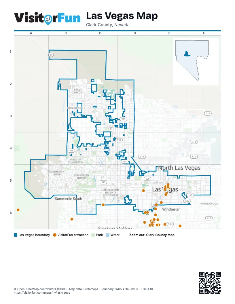
Street index of Las Vegas
Each street on the sheet and the grid squares it crosses.
- Veterans Memorial HighwayB1, B2
- Grand Teton DriveB2, C2, D2
- Iron Mountain RoadB2
- Kyle Canyon RoadB2
- North Grand Canyon DriveB2
- North Hualapai WayB2, B3, B4, B5
- North Shaumber RoadB2, B3
- Oso Blanca RoadB2, C2, C3
- Purple Heart HighwayB2, C2, C3, C4, C5, D5, E5, F5
- Sheep Mountain ParkwayB2
- Skye Village RoadB2
- Sunstone ParkwayB2, C2
- West Skye Canyon Park DriveB2, C2
- North Buffalo DriveC2, C3, C4, C5
- North Cimarron RoadC2, C3
- North Durango DriveC2, C3, C4, C5
- North Fort Apache RoadC2, C3, C4
- North Skye Canyon Park DriveC2
- North Tenaya WayC2, C3, C4, C5
- North Decatur BoulevardD2, D3, D4, D5
- North Jones BoulevardD2, D3, D4, D5
- Bruce Woodbury BeltwayB3, C3, D3, B4, B5
- Elkhorn RoadB3, C3, D3
- West Ann RoadB3, C3, D3
- West Centennial ParkwayB3, C3
- West Deer Springs WayB3, C3
- West Dorrell LaneB3
- Azure DriveC3
- Centennial Center BoulevardC3
- Farm RoadC3, D3
- Grand Montecito ParkwayC3
- John Herbert DriveC3
- North El Capitan WayC3
- North Rainbow BoulevardC3, C4, C5
- Sky Pointe DriveC3
- Tule Springs RoadC3
- West Tropical ParkwayC3, D3
- Cliff Shadows ParkwayB4
- North Desert Foothills DriveB4, B5
- Reverence ParkwayB4
- West Alexander RoadB4, C4, D4
- West Cheyenne AvenueB4, C4, D4
- West Lake Mead BoulevardB4, C4, B5, C5, D5, E5
- West Lone Mountain RoadB4, C4, D4
- Buffalo DriveC4
- Del Webb BoulevardC4
- Hills Center DriveC4, C5
- North Rampart BoulevardC4, C5
- North Rancho DriveC4, D4, D5
- West Craig RoadC4, D4
- North Torrey Pines DriveD4, D5
- Alta DriveA5, B5, C5, D5, E5
- Far Hills AvenueA5, B5
- Park Drift TrailA5, B5
- South Sky Vista DriveA5, B5
- Fleet Wing AvenueB5
- Hughes Park Drive EastB5
- Hughes Park Drive WestB5
- Kettle Ridge DriveB5
- North Anasazi DriveB5
- North Sky Vista DriveB5
- North Town Center DriveB5
- Red Rock Canyon RoadB5, B6
- South Desert Foothills DriveB5
- South Hualapai WayB5, B6
- South Pavilion Center DriveB5
- South Town Center DriveB5
- Summerlin ParkwayB5, C5
- Sunset Run DriveB5
- Village Center CircleB5, C5
- West Anasazi DriveB5
- West Charleston BoulevardB5, C5, D5, E5
- West Sky Vista DriveB5
- Rock Springs DriveC5
- Smoke Ranch RoadC5, D5
- South Buffalo DriveC5, C6
- South Durango DriveC5, C6
- South Fort Apache RoadC5, C6
- South Rainbow BoulevardC5, C6
- South Rampart BoulevardC5
- Vegas DriveC5, D5, E5
- West Washington AvenueC5, D5, E5
- Westcliff DriveC5
- North Valley View BoulevardD5
- Simmons StreetD5
- South Decatur BoulevardD5, D6
- South Jones BoulevardD5, D6
- South Rancho DriveD5, E5, D6, E6
- South Torrey Pines DriveD5
- South Valley View BoulevardD5, D6
- West Bonanza RoadD5, E5
- West Carey AvenueD5, E5
- Clark AvenueE5
- D StreetE5
- D Street ConnectorE5
- D Street–City Parkway ConnectorE5
- East Bonanza RoadE5, F5
- East Bonneville AvenueE5
- East Charleston BoulevardE5, F5
- East Owens AvenueE5, F5
- East Washington AvenueE5, F5
- Fremont StreetE5, E6, F6
- Grand Central ParkwayE5
- Harrison AvenueE5
- Industrial RoadE5, E6
- Iron Horse CourtE5
- Irwin Molasky StreetE5
- Las Vegas FreewayE5, D6, E6
- North 13th StreetE5
- North 4th StreetE5
- North Bruce StreetE5
- North Casino Center BoulevardE5
- North City ParkwayE5
- North Eastern AvenueE5
- North Las Vegas BoulevardE5
- North Main StreetE5
- North Martin Luther King Junior BoulevardE5
- North Maryland ParkwayE5
- North Rue 13E5
- South 13th StreetE5
- South Casino Center BoulevardE5
- South Commerce StreetE5, E6
- South Eastern AvenueE5, E6
- South Las Vegas BoulevardE5, E6
- South Main StreetE5, E6
- South Martin Luther King Junior BoulevardE5
- South Maryland ParkwayE5, E6
- South Rue 13E5
- Stewart AvenueE5, F5
- West Bonneville AvenueE5
- West Ogden AvenueE5
- West Owens AvenueE5
- North Lamb BoulevardF5
- North Nellis BoulevardF5
- North Pecos RoadF5
- Palm StreetF5
- South Lamb BoulevardF5
- West Desert Inn RoadB6, C6, D6
- West Sahara AvenueB6, C6, D6, E6
- West Oakey BoulevardC6, D6, E6
- Arville StreetD6
- Wilbur Clark D.I. RoadD6
- East Sahara AvenueE6, F6
- East Saint Louis AvenueE6, F6
- East Wyoming AvenueE6
- McLeod DriveE6
- North Bridge LaneE6
- Paradise RoadE6
- Sammy Davis Junior DriveE6
- West Wyoming AvenueE6
- Boulder HighwayF6
Things to do on the Las Vegas map
- Ameri-Trip
- AREA15
- Battlefield Vegas
- Comedy on Deck Tours
- Downtown Container Park
- Fremont Street Experience
- Gold & Silver Pawn Shop
- Hollywood Cars Museum
- Hypnosis Unleashed
- Las Vegas Guided Tours
- Las Vegas Outdoor Adventures
- Nostalgia Street Rods
- Rouge
- Springs Preserve
- Spy Ninjas HQ
- The Mob Museum
- The Neon Museum
- The STRAT
- Town Square Las Vegas
- Universal Horror Unleashed
Places on the map
- 18b: The Las Vegas Arts District
- Aberdeen
- Acadia Ridge
- Accent on Decatur Apartments
- Agave Ridge
- Agave Vista
- All American Park
- Allanza at the Lakes
- Allegra
- Alton
- Amber Ridge
- Amended Ridgemount
- American Coney Island
- Andalusia
- Andorra
- Angel Park
- Angel Park Golf Club
- Angel Park Golf Club - Palm
- Angel Park North Detention Basin
- Angel Park Ranch
- Archer at Sunstone
- Aria at Sunstone
- Asher at Sunstone
- Ashton Park
- Astra
- Aventura
- Aviano
- Axel at Sunstone
- Axel at Suntone
- Badlands Golf Club
- Barcelona
- Barrington
- Bella Vista
- Bellacere
- Belmonte
- Belterra
- Beltway Substation
- Berkley Square
- Blacktail
- Bloom Apartment Homes
Next to Las Vegas
- North Las Vegas map
- Summerlin South
- Sunrise Manor
- Winchester
- Winterwood
© OpenStreetMap contributors (ODbL) · Map data: Protomaps · Boundary: Who's On First (CC-BY 4.0)