

Nevada map
Nye County map
About 55,990 people live here (Census Bureau, 2024 estimate). The sheet's index lists 300 streets; Grand Army of the Republic Highway, Gabbs Pole Line Road and Veterans Memorial Highway cross the most grid squares. Things to do inside the boundary: Beatty, Pahrump Tourism Info Center and Rhyolite Ghost Town.
Open the map (PDF, US Letter)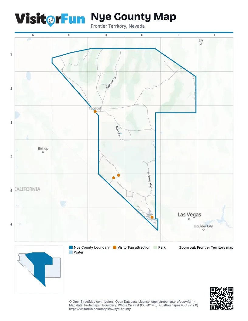
Street index of Nye County
Each street on the sheet and the grid squares it crosses.
- Veterans Memorial HighwayC4, C5, D5
- Grand Army of the Republic HighwayE1, D2, E2, C3, D3
- Tonopah–Austin RoadC1, C2, C3
- Extraterrestrial HighwayD2, D3
- Pahrump Valley HighwayD5, D6
- Silver State Classic Challenge HighwayE2, E3
- Grand Army HighwayC3
- Death Valley Junction RoadD5
- Death Valley RoadC5, D5
- Charles Brown HighwayD6
- East Main StreetC4, C5
- Erie StreetC2, C3, D6
- North Main StreetB1, C2, C3
- South 2nd StreetC5
- West Main StreetC5
- South Main StreetB1, C3
- Bell Vista RoadD5, D6
- Gabbs Valley RoadB1
- Scotty's Castle RoadC4
- Ash Meadows RoadD5, D6
- East Gamebird RoadD6
- Homestead RoadD6
- North Leslie StreetD6
- Pahrump Valley BoulevardD6
- West Bell Vista AvenueD6
- South Blagg RoadD6
- East Calvada BoulevardD6
- West Calvada BoulevardD6
- East Bell Vista AvenueD6
- South Leslie StreetD6
- West Leslie StreetD6
- East Calvada Boulevard NorthD6
- Belmont RoadC1, C2
- Gabbs Pole Line RoadB1, B2, C2, C3
- Mercury HighwayD4, D5
- Cedar Pass RoadC3, D3
- Missile Site Access RoadC3
- Duckwater RoadE1, E2
- Ione RoadB1
- South Main RoadC3, C4
- Groom Lake RoadD4
- Gold Mountain RoadC3, C4, D4
- Cedar Gate RoadD3
- Reese River RoadB1, C1
- 51 Back Gate RdD3, D4
- Rainier Mesa RoadD4
- Gold Flat RoadD3, D4
- Mellan RoadC3
- East Manhattan RoadC2
- Ione Summit RoadB1
- North Main RoadC3
- North Linda StreetD6
- North Valley View RoadD5
- East Mountain Falls ParkwayD6
- Crystal RoadD5
- North Blagg RoadD6
- West Irene StreetD6
- Mecca RoadD5
- Bunker RoadC3
- Powerline RoadD5, D6
- West Basin AvenueD6
- Round Mountain RoadC2
- West Wilson RoadD6
- East Kellogg RoadD6
- North Barney StreetD6
- Hafen Ranch RoadD6
- West Mesquite AvenueD6
- East Amargosa Farm RoadD5
- Power Line RoadD5
- Ione Road WestB1
- Radar RoadC3
- South Barney StreetD6
- Manse RoadD6
- East Thousandaire BoulevardD6
- West Simkins RoadD6
- Main StreetB1, C2, C5
- East Mesquite AvenueD6
- East Basin AvenueD6
- South Vicki Ann RoadD6
- West Amargosa F arm RoadD5
- West Charleston Park AvenueD6
- West Harris Farm RoadD6
- Turner BoulevardD6
- Red Rock DriveD6
- Jane AvenueD6
- East Simkins RoadD6
- East Manse RoadD6
- East Dandelion StreetD6
- South Bannavitch StreetD6
- Mercury BypassD5
- Hadley RoadC2
- South Dandelion StreetD6
- East Mount Charleston Drive SouthD6
- Mount Charleston DriveD6
- South Linda StreetD6
- Honeysuckle StreetD6
- Smoky Valley RoadC3
- Winchester AvenueD6
- Malibou AvenueD6
- Bannavitch StreetD6
- Charleston Park AvenueD6
- Fox RoadD6
- East Wilson RoadD6
- Hadley CircleC2
- Tecopa RoadD6
- Air Force RoadC3
- East Country Place RoadD6
- Brucite StreetB1
- Tongue WashD4
- West StreetB1, D6
- South Lola LaneD6
- Smoky Valley BoulevardC2
- East StreetC4, D6
- Cottonwood DriveC5
- Indian Reservation RoadD6
- Electrum DriveC2
- East Harris Farm RoadD6
- C.A.A.S. RoadD6
- Mountain Falls BoulevardD6
- Dandelion AvenueD6
- Dahlia StreetD6
- Clubhouse DriveD6
- E AvenueB1
- Lake View DriveD6
- East Mount Charleston DriveD6
- Yellowhand AvenueD6
- South C AvenueC5
- West Tonopah AvenueC3
- South Mountain Falls ParkwayD6
- East Carrol StreetD6
- Victoria StreetC3
- Idaho CircleC3
- Dandelion StreetD6
- West Arizona StreetC3
- Railroad Valley RoadD2, E2, D3
- Willow Creek RoadC2, C3, D3
- National Forest Development Road 139C1, D1, D2
- Dave Deacon Camp RoadE2, E3
- Pahute Mesa RoadC4, D4
- Wells Station RoadE2
- Lockes RoadD2, E2
- Little Fish Lake Valley RoadC2, D2, C3
- National Forest Development Road 164C2
- Jackass Flats RoadD5
- Tippipah Spring RoadD4
- South Newe Road 22B1, B2
- Cane Spring RoadD5
- Tippipah HighwayD4, D5
- National Forest Development Road 023C1
- Fortymile Canyon RoadD4, D5
- Burnt Cabin RoadB1
- Boulder Mesa RoadD4
- Valley RoadD4
- Golden Wash RoadB2
- National Forest Development Road 410E2, E3
- Reveille Valley RoadD2, D3
- Twin Springs Ranch RoadD2
- Tolicha Peak RoadC4
- Old Indian Springs RoadD5
- Lathrop Wells RoadD5
- New Moores Creek RoadC1
- Lodi Valley RoadB1
- Peavine RoadB2, C2
- Quinn Canyon RoadD3
- Road HD5
- Cloverdale - Peavine RoadB2, C2
- IMV Alt RoadD5
- Indian Valley RoadB2
- Hot Creek Ranch RoadD2
- Stone Cabin Ranch RoadC2, C3, D3
- Tybo-Hot Creek RoadD2
- Silver Lake RoadC2
- National Forest Development 162 RoadC2
- Short Pole Line RoadD5
- Spring Meadows RoadD5, D6
- Fremont RouteC1, C2
- National Forest Development Road 008C1
- Black Mountain RoadC4
- Del Vega StreetB1
- National Forest Development Road 010C2
- Gold Reed RoadD3
- Northumberland RoadC1
- Brown Summit Truck TrailD1, E1
- Range 77 Main RoadC4
- 27-03 RoadD5
- North RoadC3
- National Forest Development Road 440C2
- National Forest Development Road 056C2, C3
- Big Dunes RoadC5, D5
- Tybo Poleline RoadC2, D2
- Reed's Ranch RoadC3
- National Forest Development Road 020C2
- Garden Valley RoadE3
- Tybo RoadD2
- Back Mesa RoadD4
- National Forest Development Road 119B1, C1
- Quartz Mountain RoadB1
- National Forest Development Road 005C2
- Saga RoadC5
- Lunar Crater RoadD2
- Cow Canyon RoadD3
- Silverbow Mines RoadD3
- 2 Bar RoadB1
- Devils Hole RoadD5
- National Forest Development Road 002C1, D1
- Mid Valley RoadD4, D5
- National Forest Development Road 007C2
- Dead Horse FlatD4
- South Ione RoadB1
- Mine Mountain RoadD4, D5
- Rodeo RoadC1, C2
- Ff RoadD5
- Bonnie Claire RoadC4
- Cactus Spring RoadC3
- National Forest Development Road 157C2
- Nine Mile RoadD2
- National Forest Development Road 441C2
- Hicks Station RoadD2
- Degestrom RoadC5
- National Forest Development Road 345C1
- Cougars RoadC2, D2
- Moody AvenueC3
- Nyala RoadE2
- National Forest Development Road 230C2
- Stockade WashD4
- Oakridge AvenueD6
- Dump RoadC1, C2
- Berdoli Ranch RoadE2
- Cloverdale Ranch RoadB2
- North David StreetD6
- Browne's Lake RoadC3
- North Casada WayD5
- West Blosser Ranch RoadD6
- Area 71S RoadC4
- Wheeler Pass Road NorthD6
- National Forest Development Road 412E2
- Duckwater FallsE1
- Wheeler Pass Road SouthD6
- Willow Springs RoadC3
- National Forest Development Road 158C1
- Back Cactus Spring RoadC3
- Dynamite RoadC3, D5
- Edwards FreewayC3
- White BoulevardD5
- Gold Bar RoadC5
- North Woodchips RoadD6
- National Forest Development Road 415D3, E3
- North Lola LaneD6
- West Frontier StreetC5, D5
- National Forest Development Road 370C1
- Peterson Spring RoadB1
- National Forest Development Road 365C1
- West Amargosa Farm RoadC5, D5
- Lower Smoky Valley RoadB2
- Peterson Reservoir RoadD5
- Mecca Road EastD5
- Old Sunnyside CutoffE2
- Toquima RoadC1
- Jett Canyon RoadC2
- Beatty Airport RoadC5
- Peavine Canyon RoadC2
- National Forest Development Road 411E3
- Anvil RoadD5
- Panorama RoadD6
- Antelope Valley RoadD1
- Gally RoadD6
- School LaneD5
- Road FD5
- Back RoadD5
- Meadow RoadE1
- Ave 40C3
- National Forest Development Road 015C2
- Laurel DriveD5
- Orange RoadD4
- West Betty AvenueD6
- Bridger StreetD6
- G Ranch RoadD5
- Stonewall Fall RoadC4
- East Tonopah RoadC3
- Warm Springs Short CutC3, D3
- National Forest Development Road 009C1
- South Woodchips RoadD6
- Wall Canyon RoadC2
- Potts RoadC1
- Ranch RoadC5, D5
- Windjammer RoadD5
- National Forest Development Road 648E2
- Berlin-Ichthyosaur State Park RoadB1
- Imvite RoadD5
- Kittyhawk DriveD6
- Fremont TrailC1
- Frontage RoadD6
- Charleston Peak CircuitD6
- Pueblo RoadD5, D6
- Windsong LaneD6
- North Murphy StreetD6
- Scott DriveC3
- Fairbanks RoadD5
- East Elderberry StreetD6
- Penola RoadC1, C2
Things to do on the Nye County map
Places on the map
- Alta Toquima Wilderness
- Antelope Range Wilderness Study Area
- Arc Dome Wilderness
- Area 1
- Area 10
- Area 11
- Area 12
- Area 14
- Area 15
- Area 16
- Area 17
- Area 18
- Area 19
- Area 2
- Area 20
- Area 22
- Area 23
- Area 25
- Area 26
- Area 27
- Area 29
- Area 3
- Area 30
- Area 4
- Area 5
- Area 6
- Electronic Combat East
- Electronic Combat Systems (ECS)
- Electronic Combat West
- Former Palisade Mesa WSA
- Nevada National Security Site
- Range 71N
- Range 71S
- Range 74 A
- Range 75 East
- Range 75 West
- Range 76
- Red Zone
- Table Mountain Wilderness
- Tonopah Test Range 52
Next to Nye County
- Bishop
- Boulder City map
- Ely
- Las Vegas map
© OpenStreetMap contributors, Open Database License, openstreetmap.org/copyright · Map data: Protomaps · Boundary: Who's On First (CC-BY 4.0); Quattroshapes (CC BY 2.0)















