

New York map
Babylon map
About 12,193 people live here (Census Bureau, 2024 estimate). The sheet's index lists 300 streets; Broadway, Oak Street and Park Avenue cross the most grid squares. Things to do inside the boundary: Adventureland.
Open the map (PDF, US Letter)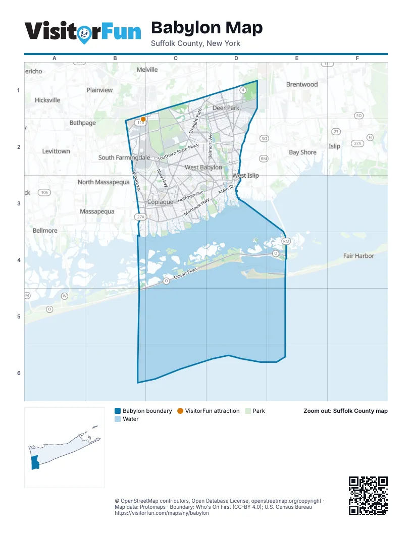
Maps inside Babylon
2 maps inside, from the street map of Babylon down.
Street index of Babylon
Each street on the sheet and the grid squares it crosses.
- Sunrise HighwayC2, D2, B3, C3
- Southern State ParkwayB2, C2, D2
- County Line RoadB2, B3
- Robert Moses CausewayE4
- Ocean ParkwayC4, D4, E4, B5
- Farmingdale RoadB2, C2, D2, D3
- Deer Park AvenueD1, D2, D3
- Broadhollow RoadB1, B2
- BroadwayB2, C2, D2, B3, C3, C4
- Babylon-Northport ExpresswayD2, D3
- Little East Neck Road NorthC2, D2, D3
- Commack RoadD1, D2
- Conklin StreetD1, B2, C2, D2
- Montauk HighwayC3, D3
- West Sunrise HighwayC3
- West Montauk HighwayC3
- Merrick RoadB3, C3
- West Main StreetD3
- Seversky RoadB2, C2
- East Montauk HighwayC3
- East Main StreetD3
- Sunrise Highway South Service RoadC2, D2
- Broad Hollow RoadB2
- Babylon Farmingdale RoadD3
- Straight PathC1, D1, C2, C3
- New HighwayC1, C2, C3
- North Wellwood AvenueC2, C3
- Great Neck RoadB2, B3, C3
- Oak StreetD1, B2, C2, B3, C3, D3
- Belmont AvenueD2
- Little East Neck RoadC1, C2
- Wellwood AvenueC1, C2, C3
- Melville RoadB2
- East Hoffman AvenueC3
- South Wellwood AvenueC3
- West Hoffman AvenueC3
- Dixon AvenueB3, C3
- Railroad AvenueB3, C3, D3
- Great East Neck RoadD3
- Bay Shore RoadD2
- Bergen AvenueD3
- John StreetB3, D3
- Trolley Line RoadD3
- Cooper StreetD3
- Sunrise Highway North Service RoadD2
- West Oak StreetB3
- Pinelawn RoadC1
- Main StreetD1, B2, B3
- Simon StreetD3
- Belmont Avenue SouthD2
- South Jerome AvenueD2
- Parkway ExitB3
- Long Island AvenueC1, D1, C2
- Albany AvenueC2, D2, B3, C3
- Grand BoulevardC1, D1, C2, D2
- Nicolls RoadC1, D1
- Park AvenueD1, D2, B3, C3, D3
- Smith StreetB1, C1, D1, D2, D3
- Robert Moses State ParkwayE4
- Herzel BoulevardC2
- Half Hollow RoadD1, D2
- August RoadD2
- Deauville BoulevardC3
- Wyandanch AvenueC2, D2
- Lake AvenueD1
- Edison AvenueC2
- New York AvenueD1, C2, C3
- Acorn StreetC1, D1
- Arnold AvenueC2, C3, D3
- North Delaware AvenueC3
- Sylvan RoadD2
- South BroadwayC3
- Bayview AvenueC3, D3
- Liberty AvenueD2, C3
- Shore RoadB3, C3, D3
- Carlls PathD1
- East John StreetC3
- Mount AvenueC2, D2
- Old Farmingdale RoadC2, D2
- Colonial Springs RoadC1
- East Carmans RoadB2
- Woods RoadD2
- 18th StreetC1, C2
- Livingston AvenueD2, D3
- Main AvenueC1
- Essex StreetC2, D2
- Carll's PathD1, D2
- Frank StreetC2, C3
- West 23rd StreetD1, D2
- Marconi BoulevardC3
- Miller AvenueC2, D2, C3
- West 16th StreetD1, D2
- Hubbards PathD2
- Prairie DriveD2
- South Strong AvenueC3
- 35th StreetC3
- Phelps LaneD2
- Weeks RoadD2
- Bethpage RoadC3
- South Delaware AvenueC3
- Hilltop AvenueC2
- Hunter AvenueD2
- 22nd StreetC1
- North 18th StreetC1
- Albin AvenueC3, D3
- Conklin AvenueC1
- Arthur AvenueC2, D2
- Louden AvenueB3
- Secatogue AvenueB2
- Henry AvenueD2
- Strongs AvenueC3
- Doe StreetC1, C2
- Burrs LaneC1
- Jenkins AvenueD2
- North Strongs AvenueC3
- Pinto StreetD2
- South 18th StreetC1, C2
- Carlls Straight PathD1
- North Strong AvenueC3
- Laurel StreetD2
- Statesman StreetD2
- Rowland PlaceD2
- Jerome AvenueD2
- Louden StreetB3
- Statesman AvenueD2
- Central AvenueC1, D1, C2, D2, B3
- Washington AvenueC1, D1, D2, B3, C3
- Old Country RoadC1, D1
- Irving AvenueD1, C2, D2, C3
- 4th StreetB2, C2
- Jefferson AvenueD1, C2, D2, B3, C3
- 7th StreetC2
- Patton AvenueC2
- 3rd StreetC2
- 11th StreetC2
- 12th StreetC2
- 6th StreetC2
- 14th StreetC2
- 15th StreetC2
- Lake DriveC1, C2, C3
- 9th StreetC2
- 17th StreetC2
- 10th StreetC2
- 5th StreetC2
- Lincoln AvenueB2, C2, D2, C3
- Grand AvenueB2, C2, C3
- Oak Beach RoadD4
- North Indiana AvenueC2, C3
- North Fulton AvenueC3
- North Hamilton AvenueC2, C3
- North Monroe AvenueC2, C3
- North Greene AvenueC3
- Oakland AvenueD2
- South 5th StreetC3
- North Erie AvenueC3
- South AvenueC2
- 44th StreetC3
- Brook AvenueD1, C2, D2
- North Clinton AvenueC3
- Jackson AvenueC3
- North AvenueC2
- North Broome AvenueC3
- South 6th StreetC3
- South 7th StreetC3
- Catskill AvenueC3
- Heathcote RoadC2, C3
- South 8th StreetC3
- 45th StreetC3
- Hawkins BoulevardC3
- Liberty StreetD1, C3
- Ocean AvenueD1, C3, C4
- North Alleghany AvenueC3
- Adams StreetC1, D1, B2
- 43rd StreetC3
- Ralph AvenueD2, C3, D3
- Merritt AvenueC1, C2
- 42nd StreetC3
- South 4th StreetC3
- Doctor Frank A Cipriani DriveB1, B2
- Buffalo AvenueC3
- Little East Neck Road SouthD3
- Columbus AvenueC2, D2
- Erlanger BoulevardD2
- Schleigel BoulevardB2, C2, C3
- Skidmore RoadD1, D2
- Lakeway DriveC2, D2
- East DriveC2, C3, C4
- Centre AvenueC2, C3
- West 18th StreetD1, D2
- Silver StreetC2, D2
- Cedar StreetC2, B3, C3, D3
- Richmond AvenueB3, C4
- Windmill AvenueC2, D2
- Venetian BoulevardC3, D3
- Coolidge AvenueB3, C3, C4
- Colonial RoadC2, D2, C3
- Claremont AvenueC2, D2
- Peconic AvenueC2, D2
- Sherbrooke RoadC2, C3
- Burlington AvenueD1
- Lexington AvenueC2, D2
- Outlook AvenueC2, D2
- Chelsea AvenueC2, D2
- 41st StreetC3
- Neptune AvenueC2, D2
- America AvenueC2, D2
- Daniel StreetB2, C3
- Sheffield AvenueC2, D2
- Garden City AvenueC2
- Fire Island AvenueD3
- Fulton StreetD1, C2
- Brooklyn AvenueC2
- West 22nd StreetD1, D2
- Madison AvenueD1, B3, C3
- Newark StreetC3
- Manhattan AvenueC2, D2
- Litchfield AvenueD2, D3
- Locust AvenueC1, B3, D3
- Ridge RoadC1
- Grand Central AvenueC3, C4
- West 21st StreetD1, D2
- Amsterdam AvenueC2, D2
- Pine Acres BoulevardD1
- 2nd AvenueC2, C3
- West 20th StreetD1, D2
- Farmers AvenueC2, C3
- South 9th StreetC3
- New Horizons BoulevardC2, C3
- West 19th StreetD1, D2
- State AvenueC2, D2
- Westchester AvenueC2
- South 25th StreetC1, C2
- West 17th StreetD1, D2
- Main Portal DriveC1, C2
- West 15th StreetD1, D2
- Montgomery AvenueC2, D2
- West Gates AvenueC3
- West 8th StreetD1, D2
- Lafayette RoadD2
- Reade AvenueC3
- Eastwood AvenueD1
- Centerwood StreetC2
- Granada ParkwayC3, D3
- Wright AvenueD1
- Cadman AvenueD2, D3
- 13th StreetC2
- West 10th StreetD1, D2
- Elmwood RoadD1, D2, C3, D3
- South 24th StreetC1, C2
- South Walnut StreetC3
- West 9th StreetD1, D2
- 40th StreetC3
- South Bayview AvenueC3, C4
- William StreetC2, D2, B3, C3, D3
- West 7th StreetD1, D2
- 13th AvenueC2
- Cheltenham RoadD2
- Tremont RoadC2, C3
- West 6th StreetD1, D2
- Scott AvenueD2
- Montefiore AvenueC2
- Fourth Avenue SouthC2
- Gleeland StreetD1
- Second Avenue SouthC2
- South 13th StreetC3
- Pacific StreetD2, C3
- South 14th StreetC3
- Fourth Avenue NorthC2
- South 15th StreetC3
- Waldo StreetC3
- Bond StreetC2, C3, D3
- Lafayette StreetC3
- South 16th StreetC3
- West 2nd StreetD1, D2
- 16th StreetC1, C2
- Van Buren StreetB2, C2, D2
- 3rd AvenueC2, C3
- 15th AvenueC2
- South Pecan StreetC3
- Birch Avenue EastB2
- 14th AvenueC2
- Osceola AvenueD1
- Wilson AvenueD1, C3
- Feustal StreetC2
- Allen BoulevardB2, C2
- West 14th StreetD1, D2
- Second Avenue NorthC2
- Third Avenue NorthC2
- First Avenue NorthC2
- West 5th StreetD1, D2
- Mohawk AvenueD1
- New AvenueC2
- North 5th StreetD1, C3
- West 13th StreetD1, D2
- Quail Run DriveD1
- South 2nd StreetC3
- Cayuga AvenueD1
- First Avenue SouthC2
- South 1st StreetC3
- East Riviera DriveC3
Things to do on the Babylon map
Places on the map
- #2 Nemophilist
- Airport Plaza
- Anchorage Yacht Club
- Argyle Lake
- Belmont Lake
- Bergen Point Golf Course
- Beth Moses Cemetery
- Brunswick Hospital Center
- Carlls River
- Carlls River Botanical Garden
- Cedar Beach
- Colonial Springs Golf Club
- Copiague
- Copiague Neck County Park
- Deer Park
- East Farmingdale
- Edgewood Oak Brush Plains Preserve
- Field 2
- Gilgo
- Gilgo State Park
- Guggenheim Lakes
- Lindenhurst High School
- Long Island National Cemetery
- Mount Ararat Cemetery
- New Montefiore Cemetery
- North Amityville
- North Babylon
- North Lindenhurst
- Oak Beach
- Pinelawn Memorial Park
- Republic Plaza
- Southards Pond
- Southards Pond Park
- Tanger Outlets
- Usdan Music and Arts Camp
- Village of Amityville
- Village of Lindenhurst
- West Babylon
- Wheatley Heights
- Wyandanch
Next to Babylon
- Bay Shore
- Baywood
- Bellmore
- Bethpage
- Brentwood
- East Islip
- East Massapequa
- Fair Harbor
- Farmingdale
- Hicksville
- Islip
- Jericho
- Levittown
- Massapequa
- Melville
- North Massapequa
- Ocean Beach
- Plainedge
- Plainview
- Seaford
- South Farmingdale
- Wantagh
- West Islip
© OpenStreetMap contributors, Open Database License, openstreetmap.org/copyright · Map data: Protomaps · Boundary: Who's On First (CC-BY 4.0); U.S. Census Bureau















