

New York map
Bay Ridge map
A printable two-page map of Bay Ridge (Brooklyn, New York), drawn by VisitorFun from OpenStreetMap. Page two is the street index: every street on the sheet with its grid square, the same list as below.
Open the map (PDF, US Letter)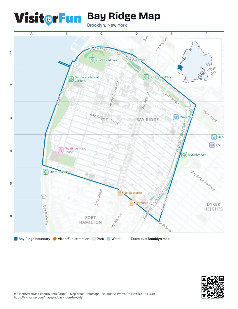
Street index of Bay Ridge
Each street on the sheet and the grid squares it crosses.
- 68th StreetB1, C2, D2, E3, F3
- Bay Ridge AvenueB1, D2, E3
- Belt ParkwayB1, C1, D1, B2, A3, B3, A4
- Owls Head CourtB1, B2
- Shore RoadB1, C1, B2, B3, A4, B4
- 67th StreetC1, D1, D2, E2, E3, F3
- Bergen PlaceC1, D1
- Colonial RoadC1, C2, C3
- Narrows AvenueC1, C2, B3, B4
- Sedgwick PlaceC1
- Senator StreetC1, D2, E2, E3
- Shore Road DriveC1, D1, D2, E2
- Wakeman PlaceC1, D1, D2
- 2nd AvenueD1
- 3rd AvenueD1, D2, C3, D3
- 65th StreetD1, E2
- Ridge BoulevardD1, D2, C3
- 70th StreetB2, C2, E3
- 71st StreetB2, D3, E3, E4
- 72nd CourtB2
- 72nd StreetB2, D3, E3, E4
- 73rd StreetB2, D3, E3, E4
- Mackay PlaceB2, C2
- Bay Cliff TerraceC2
- Bay Ridge PlaceC2, D2
- Bliss TerraceC2
- Louise TerraceC2
- Ovington AvenueC2, D2, D3, E3
- Perry TerraceC2
- Ridgecrest TerraceC2
- 4th AvenueD2, E2, D3, D4, D5
- Madeline CourtD2
- 5th AvenueE2, D3, E3, D5
- 66th StreetE2, F3
- 6th AvenueE2, E3, E4, D5
- Erik PlaceE2, E3
- Gowanus ExpresswayE2, E3, F3, E4, E5, D6, E6
- Gowanus Expressway (HOV)E2, E3, E4, E5, D6
- 74th StreetB3, C3, D3, E4
- 76th StreetB3, C3, D3, D4, E4
- 77th StreetB3, C3, D4, E4, E5
- 78th StreetB3, C3, D4, E5
- 79th StreetB3, B4, C4, D4, E5
- 80th StreetB3, B4, D4, E5
- Bay Ridge ParkwayB3, D3, E4
- Harbor View TerraceB3, B4
- Bennett CourtD3
- Ridge CourtD3
- 7th AvenueE3, F3, E4, E5
- Stewart AvenueE3, E4
- Vista PlaceE3
- Shore Road LaneA4, B4
- 81st StreetB4, D4, D5, E5
- 82nd StreetB4, C4, D5, E5
- 83rd StreetB4, C4, D5, E6
- 84th StreetB4, D5, D6, E6
- 85th StreetB4, C5, D5, D6, E6
- Colonial CourtB4
- Harbor LaneB4
- Westerly LaneB4
- 8th AvenueE4
- 86th StreetC5, D6
- Fort Hamilton ParkwayD5, E5, D6
- Dyker PlaceE5, D6, E6
- Dahlgren PlaceD6
- Battery AvenueE6
Places on the map
- 77th Street
- Adelphi Academy
- American Veterans Memorial Pier
- AT&T
- Balady Halal Market
- Bay Ridge Avenue
- Bay Ridge Baptist Church
- Bay Ridge Manor
- Best Western Gregory Hotel
- Bethlehem Lutheran Church
- Brooklyn Harvest Market
- Brooklyn Public Library
- Burger King
- C-Town
- Capital One
- Chase
- Clavin Funeral Home
- Empire Nissan of Bay Ridge
- Empire Nissan of Bay Ridge Service & Parts
- FDNY Engine 241/Ladder 109
- Fort Hamilton Athletic Field
- Fort Hamilton High School
- Fourth Avenue Presbyterian Church
- Gap
- Gateway City Church
- Good Shepherd Lutheran Church
- High School of Telecommunication Arts and Technology
- Holy Cross Greek Orthodox Church
- Horizon Christian Fellowship Church
- Key Food
- Leif Ericson Park
- Lexus of Bay Ridge
- Met Foods
- Mikes Deli
- Millennium Skate Park
- Narrows Botanical Gardens
- NYU Langone Ambulatory Care Bay Ridge
- Our Lady of Angels Roman Catholic Church
- Our Savior's Lutheran Church
- Owl’s Head Park
Next to Bay Ridge
- Dyker Heights map
- Fort Hamilton
© OpenStreetMap contributors (ODbL) · Map data: Protomaps · Boundary: Who's On First (CC-BY 4.0)