

New York map
Bellerose map
A printable two-page map of Bellerose (Queens, New York), drawn by VisitorFun from OpenStreetMap. Page two is the street index: every street on the sheet with its grid square, the same list as below.
Open the map (PDF, US Letter)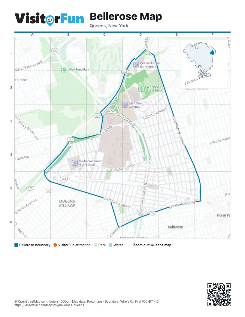
Street index of Bellerose
Each street on the sheet and the grid squares it crosses.
- 252nd StreetD1, D2, E2, E3, E5
- 260th StreetD1
- 71st AvenueD1
- 71st RoadD1
- Grand Central ParkwayD1, C2, D2, B3, C3, A4, B4
- Little Neck ParkwayD1, E2, E3, E4, F5
- 249th StreetD2, D3, E4, E5
- 250th StreetD2, E3, E4, E5
- 251st StreetD2, E3, E4, E5
- 72nd AvenueD2
- 76th AvenueD2, D3
- 77th CrescentD2, D3
- Commonwealth BoulevardD2, D3, D4, E5, E6
- Elkmont AvenueD2, E2
- 74th AvenueE2
- 75th AvenueE2
- Shiloh AvenueE2, D3
- Alley Pond Park State RouteC3
- Cross Island ParkwayC3, D3, D4, D5, D6
- Douglaston ParkwayC3
- Union TurnpikeC3, D3, E3, B4, C4
- Winchester BoulevardC3, C4, B5, C5
- 242nd StreetD3, D4, D5, D6
- 243rd StreetD3, D4, D6
- 244th StreetD3, D6
- 246th StreetD3, D4, D5, D6
- 247th StreetD3, E4, D5, E5, D6
- 248th StreetD3, E4, E5
- 80th RoadD3
- 81st AvenueD3, E3
- 80th AvenueE3
- 82nd AvenueE3, D4
- 82nd DriveE3, E4
- 82nd RoadE3
- Stronghurst AvenueA4, B4, A5
- 229th StreetB4, B5
- 230th StreetB4
- 231st StreetB4, B5
- 232nd StreetB4, B5
- 233rd StreetB4, C5
- 234th StreetB4, C4
- Hillside AvenueB4, C4, D4, E4, B5
- Manor RoadB4, B5
- Seward AvenueB4, C4
- 235th CourtC4, C5
- 235th StreetC4
- 236th StreetC4
- 237th StreetC4, C5
- Musket StreetC4, C5
- Range StreetC4, C5
- 239th StreetD4, C5, D5, D6
- 240th StreetD4, D5, D6
- 241st StreetD4, D5, D6
- 83rd AvenueD4, E4
- 84th RoadD4
- 85th AvenueD4, E4
- 85th RoadD4, E4, F4, D5, E5
- 253rd StreetE4, E5
- 84th DriveE4
- East Williston AvenueE4
- Braddock AvenueA5, B5, C5, D5, D6
- Springfield BoulevardA5, B5
- 87th AvenueB5, C5, D5, E5, F5
- 88th AvenueB5, C5, D5
- Ashford StreetB5
- Billings StreetB5
- 222nd StreetC5
- 238th StreetC5
- 89th AvenueC5, D5, E5
- 92nd RoadC5
- Gettysburg StreetC5
- Lyman StreetC5
- Moline StreetC5
- Pontiac StreetC5
- Ransom StreetC5
- Sabre StreetC5
- 86th AvenueD5, E5
- 86th RoadD5, E5
- 88th DriveD5, E5
- 88th RoadD5, E5
- 90th AvenueD5, E6
- 91st AvenueD5, D6
- 254th StreetE5, F5
- 87th DriveE5, F5
- 87th RoadE5, F5
- Jamaica AvenueE5, C6, D6, E6
- Davenport AvenueC6
- Edmore AvenueC6
- 245th StreetD6
- 93rd AvenueD6
- 93rd RoadD6
- Fairbury AvenueD6
- Jericho TurnpikeE6
Places on the map
- Association for Neurologically Impaired Brain Injured Children
- Bell Park Manor Terrace
- Bellrose Assembly of God
- Breininger Park
- Butterfly Garden
- Cammps
- Castlewood Playground
- Chickens
- Country Pointe Circle
- Creedmoor Psychiatric Center
- Creedmoor Soccer Fields
- Cross Island YMCA
- Father Reder Senior Apartments
- Flower Field
- Glen Oaks Campus
- Growing Field
- Holy Trinity Evangelical Lutheran Church
- Honeybee Garden
- House of Hope Presbyterian Church
- Implement Garden
- Key Food
- Livestock Paddlock
- Maharaja Farmer's Market
- Manor Road
- Martin Van Buren High School
- New York City Children's Center - Queens Campus
- New York Community Bank
- P.S. 133Q - The Bellerose School of Excellence
- P.S. 18 - Winchester School
- P.S. 186 - Castlewood School
- Padavan-Preller Fields
- Patel Brothers
- Patrol Officer William T Gunn Junior Park
- Perennial Berries
- Perennial Herbs
- Pigs!
- PM Pediatric Urgent Care
- Pumpkin patch
- Queens Center for Progress
- Queens County Farm Museum
Next to Bellerose
- Bellerose Terrace
- Floral Park map
- Glen Oaks map
- Queens Village map
© OpenStreetMap contributors (ODbL) · Map data: Protomaps · Boundary: Who's On First (CC-BY 4.0)