

New York map
Black Rock map
A printable two-page map of Black Rock (Buffalo, New York), drawn by VisitorFun from OpenStreetMap. Page two is the street index: every street on the sheet with its grid square, the same list as below.
Open the map (PDF, US Letter)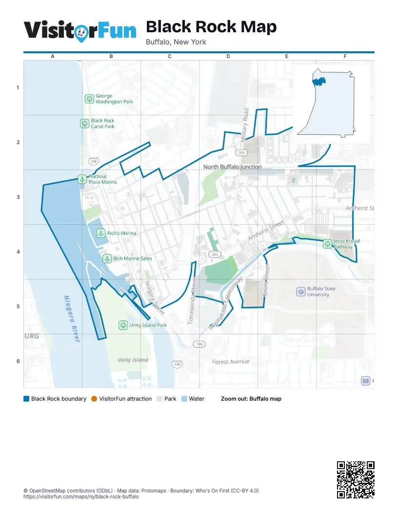
Street index of Black Rock
Each street on the sheet and the grid squares it crosses.
- Jasper Parrish DriveE1, E2
- Arthur StreetB2, B3
- Garfield StreetB2, B3
- Hartman PlaceB2, B3
- Niagara StreetB2, B3, B4, C5
- Peoria StreetB2
- Hertel AvenueC2, D2, E2, F2, B3
- River Rock DriveC2
- Deer StreetD2
- Foundry StreetD2
- Laforce PlaceD2
- Military RoadD2, D3, D4
- Short StreetD2
- Debra LaneE2
- Grove StreetE2
- Janice StreetE2
- Pavonia StreetE2
- Saint Florian StreetE2
- Sunnyside PlaceE2
- Sunset StreetE2
- Norris StreetF2
- Dearborn StreetB3, B4, C4, C5
- East StreetB3, C4, C5
- Farmer StreetB3, C3
- Grace StreetB3
- Marint Vista EntranceB3
- Marint Vista ExitB3
- Niagara ThruwayB3, B4, B5, C5
- Austin StreetC3, D3, B4, C4
- Gorton StreetC3, C4
- Guernsey StreetC3, C4
- Harp PlaceC3
- Pacific StreetC3
- Thompson StreetC3, C4
- Tonawanda StreetC3, C4, D4
- Chandler StreetD3, F3
- Clay StreetD3, D4
- Germain StreetD3, E3, E4
- Glor StreetD3, D4
- Grant StreetD3, D4, E4
- Grote StreetD3, F3
- Joslyn PlaceD3
- Kail StreetD3, D4
- Lansing StreetD3
- Peter StreetD3, E3, E4
- Amherst StreetE3, F3, C4, D4, E4, C5
- Bridgeman StreetE3
- Bush StreetE3, E4
- Howell StreetE3, E4
- Manton PlaceE3
- Marion StreetE3, F3
- Reservation StreetE3
- Beaumaris PlaceF3, F4
- Bedford AvenueF3
- Elmhurst PlaceF3
- Elmwood AvenueF3, F4
- Woodette PlaceF3
- Dann StreetB4, B5
- Hamilton StreetB4, C4
- Hoffman PlaceC4
- St Francis PlaceC4
- Churchill StreetD4
- Private DriveD4
- Scajaquada ExpresswayD4, E4, D5
- Chatham AvenueF4
- Elmview PlaceF4
- Fordham DriveF4
- Middlesex RoadF4
- Bridge StreetC5
- Parrish StreetC5
- Dart StreetD5
Places on the map
- 7-Eleven
- Acqua
- Allentown Music
- Amazon Locker - Dorm
- Amherst Street Wine & Liquor
- Austin St Boat Launch
- Bank of America
- Barrel + Brine Cafe and Market
- Black Rock
- Black Rock Lock
- Black Rock Peace Garden
- BlackBird Cider Works Buffalo Cider Hall
- Boys & Girls Clubs of the Northtowns Black Rock Assuption Club
- Buffalo Police Department D District
- Burger King
- Carm's Barber Shop
- CCF Auto
- Chandler Street Market
- Charity Baptist Church
- Chase
- Church of the Assumption of the Blessed Virgin Mary
- CP 7
- CP I
- Crenshaw's Chicken and Waffles
- DaVita Dialysis
- Dearborn Street Little Free Library
- Family Dollar
- Farmer's Garden
- Faso's Ristorante
- Fast Stop Food Mart
- Fresh Arabic Sweets
- Gather and Game
- Grand Trunk Railway Company Black Rock Freight Office
- Harbour Place Marina
- Hertel Ave & Military Rd (EB)
- Hot Mama’s Canteen
- Jasper Parrish Homes
- KeyBank
- Linde Air Building
- Lot G-20
© OpenStreetMap contributors (ODbL) · Map data: Protomaps · Boundary: Who's On First (CC-BY 4.0)