

New York map
Buffalo map
A printable two-page map of Buffalo (Erie County, New York), drawn by VisitorFun from OpenStreetMap. Page two is the street index: every street on the sheet with its grid square, the same list as below.
Open the map (PDF, US Letter)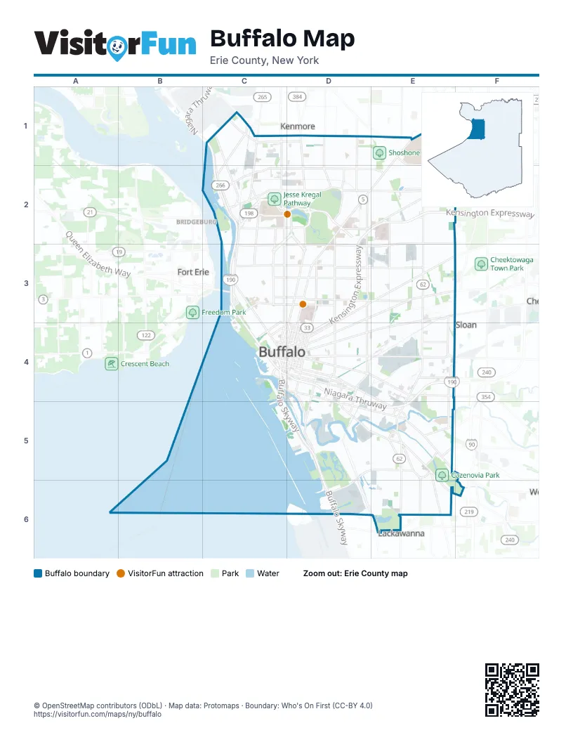
Street index of Buffalo
Each street on the sheet and the grid squares it crosses.
- Elmwood AvenueC1, C2, C3
- Hinman AvenueC1, D1
- Kenmore AvenueC1, D1, E1
- Military RoadC1, C2
- Niagara StreetC1, C2, C3, C4
- Niagara ThruwayC1, C2, C3, C4, D4, E4, D5, E5
- Ontario StreetC1, C2
- Skillen StreetC1
- Vulcan StreetC1
- Colvin AvenueD1, D2
- Colvin BoulevardD1
- Delaware AvenueD1, D2, D3, C4, D4
- Starin AvenueD1, D2
- Bailey AvenueE1, E2, E3, E4, E5
- Main StreetE1, D2, E2, D3, D4
- Niagara Falls BoulevardE1
- Winspear AvenueE1
- Amherst StreetC2, D2
- Austin StreetC2
- Bidwell ParkwayC2, D2, C3
- Dann StreetC2
- Forest AvenueC2, D2
- Grant StreetC2, C3
- Hamilton StreetC2
- Hertel AvenueC2, D2, E2
- Iroquois DriveC2, D2
- Letchworth StreetC2
- Richmond AvenueC2, C3
- Rockwell RoadC2
- Scajaquada ExpresswayC2, D2
- Tonawanda StreetC2
- Chapin ParkwayD2, D3
- East Amherst StreetD2, E2
- Fillmore AvenueD2, D3, D4
- Jefferson AvenueD2, D3, D4
- Kensington AvenueD2, E2
- Kensington ExpresswayD2, E2, D3, D4
- Lincoln ParkwayD2
- Nottingham TerraceD2
- Parkside AvenueD2
- Soldiers CircleD2
- Berkshire AvenueE2
- Berwyn AvenueE2
- Burlington AvenueE2
- Cloverdale AvenueE2
- East Delavan AvenueE2, F2, D3, E3
- Eggert RoadE2, F2
- Grider StreetE2, E3
- West Cleveland DriveE2, F2
- Cleveland DriveF2
- Baird DriveC3
- Busti AvenueC3
- Colonial CircleC3
- Edward StreetC3, D4
- Ferry CircleC3
- North StreetC3, D3
- Porter AvenueC3
- Sheridan TerraceC3
- South Elmwood AvenueC3, C4
- Summer StreetC3, D3
- Symphony CircleC3
- Virginia StreetC3, C4
- West Delavan AvenueC3, D3
- West Ferry StreetC3, D3
- West Utica StreetC3, D3
- Best StreetD3, E3
- BFMC DriveD3, D4
- Cherry StreetD3, D4
- East Ferry StreetD3, E3
- East North StreetD3
- East Utica StreetD3
- Gates CircleD3
- Genesee StreetD3, E3, F3, D4
- Humboldt ParkwayD3
- Michigan AvenueD3, D4
- Sycamore StreetD3, E3, D4
- BroadwayE3, D4, E4
- Broadway StreetE3
- North Ogden StreetE3, E4
- Walden AvenueE3, F3
- Buffalo SkywayC4, C5, D5, D6
- Carolina StreetC4
- Church StreetC4, D4
- Commercial StreetC4
- Court StreetC4, D4
- Erie StreetC4
- Exchange StreetC4, D4
- Franklin StreetC4, D4
- Lower TerraceC4
- Marine DriveC4
- Niagara SquareC4
- Pearl StreetC4, D4
- Perkins DriveC4
- Perry StreetC4
- Scott StreetC4
- Seymore H. Knox III PlazaC4
- South Park AvenueC4, D4, D5, E5, E6
- Washington StreetC4, D4
- West Chippewa StreetC4, D4
- West Huron StreetC4, D4
- West Seneca StreetC4, D4
- West Swan StreetC4, D4
- West Tupper StreetC4, D4
- Clinton StreetD4, E4
- East Chippewa StreetD4
- East Huron StreetD4
- East Tupper StreetD4
- Ellicott StreetD4
- Elm StreetD4
- Goodell StreetD4
- Hamburg StreetD4
- Lafayette SquareD4
- Louisiana StreetD4, D5
- North Division StreetD4
- North Oak StreetD4
- Oak StreetD4
- Ohio StreetD4, D5
- Pine StreetD4
- Seneca StreetD4, E4, E5, F5
- Smith StreetD4, D5
- South Division StreetD4
- Swan StreetD4
- Van Rensselaer StreetD4, D5
- William StreetD4, E4
- Cliff StreetE4
- Dingens StreetE4
- East Lovejoy StreetE4
- Griswold StreetE4
- Richard DriveE4
- South Ogden StreetE4, E5
- Elk StreetD5, E5
- Fuhrmann BoulevardD5, D6
- Outer Harbor DriveD5
- Tifft StreetD5, E5, D6
- Abbott RoadE5, E6
- Cazenovia StreetE5
- Indian Church RoadE5
- Keating StreetE5
- McClellan CircleE5
- McKinley ParkwayE5, E6
- Mineral Springs RoadE5
- Potters RoadE5, E6
- Red Jacket ParkwayE5
- Southside ParkwayE5
- Dorrance AvenueE6
- McKinley CircleE6
- Onondaga AvenueE6
- South Shore BoulevardE6
- Ward CourtE6
Things to do on the Buffalo map
Places on the map
- *
- 4th Street Park
- 589 Ellicott Lot
- Agway Elevator
- American/Peavey Elevator
- Amherst Quarry Lake
- Arnold B. Gardner Memorial Lending Library
- Aurubis Baseball Fields
- Aurubis Buffalo, Inc.
- Axis 360 Apartments
- Barcalo Living & Commerce
- Berm Pond
- Beth Pond
- Bidwell Parkway
- Black Rock Canal Park
- Black Rock Lock
- Bog Garden
- Broderick Park
- Brylin Hospital
- Buffalo / Kreiner Malting Grain Elevator
- Buffalo AKG Art Museum
- Buffalo and Erie County Naval & Military Park
- Buffalo China Complex
- Buffalo Coast Guard Slip
- Buffalo Engine Components
- Buffalo Equestrian Center
- Buffalo Harbor State Park
- Buffalo Lakeside Commerce Park
- Buffalo Niagara Medical Campus
- Buffalo Place
- Buffalo Post Office
- Buffalo Psychiatric Center
- Buffalo RiverWorks
- Buffalo RiverWorks Parking Lot
- Buffalo State University
- Buffalo VA Medical Center
- Buffalo Zoo
- Buffalo–Exchange Street Station
- Buflovak
- Canisius University
Maps inside Buffalo
- Albright map
- Allentown map
- Black Rock map
- Broadway Fillmore map
- Buffalo River map
- Central map
- Central Park map
- Cold Springs map
- Delavan-Grider map
- Ellicott map
- Elmwood Bidwell map
- Elmwood Bryant map
- Fillmore-Leroy map
- First Ward map
- Fruit Belt map
- Genesee-Moselle map
- Grant-Amherst map
- Hamlin Park map
- Hopkins-Tifft map
- Kaisertown map
- Kenfield map
- Kensington-Bailey map
- Lovejoy map
- Lower West Side map
- MLK Park map
- Masten map
- Masten Park map
- North Buffalo map
- North Park map
- Old First Ward map
- Park Meadow map
- Parkside map
- Pratt-Willert map
- Riverside map
- Schiller Park map
- Seneca Babcock map
- Seneca-Cazenovia map
- South Buffalo map
- South Park map
- State Hospital map
- University Heights map
- Upper West Side map
- Waterfront District map
- West Hertel map
- West Side map
Next to Buffalo
- Bridgeburg
- Eggertsville
- Fort Erie
- Kenmore
- Lackawanna
- Sloan
© OpenStreetMap contributors (ODbL) · Map data: Protomaps · Boundary: Who's On First (CC-BY 4.0)