

New York map
East Hampton map
About 1,556 people live here (Census Bureau, 2024 estimate). The sheet's index lists 103 streets; Georgica Road, Huntting Lane and Lily Pond Lane cross the most grid squares. Also on it: 1770 House Restaurant & Inn, Amy's Court and Chauncey Close.
Open the map (PDF, US Letter)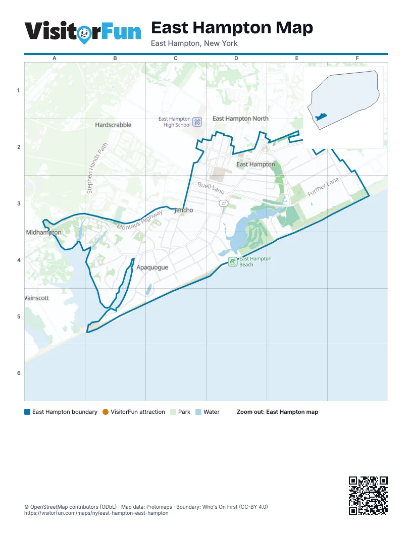
Street index of East Hampton
Each street on the sheet and the grid squares it crosses.
- Gingerbread LaneC2, D2
- King StreetC2, D2
- Newtown LaneC2, D2
- Stratton SquareC2, D2
- Toilsome LaneC2, C3
- Cedar StreetD2
- Church StreetD2, D3
- Collins AvenueD2
- Conklin TerraceD2
- Cooper LaneD2
- Fithian LaneD2, E2
- Fresno PlaceD2
- Gay RoadD2, E2
- Gingerbread Lane ExtensionD2
- Gould StreetD2
- Hook Mill RoadD2, E2
- Huntting LaneD2, E2, D3, E3
- Ina Garten WayD2
- Lumber LaneD2
- Maidstone AvenueD2, C3
- Main StreetD2, D3
- Mc Guirk StreetD2
- MedwayD2
- Methodist LaneD2
- Muchmore LaneD2
- North Main StreetD2
- Osborne LaneD2
- Pantigo RoadD2, E2
- Park PlaceD2
- Pleasant LaneD2
- Race LaneD2
- Railroad AvenueD2
- Sherrill RoadD2
- Talmage LaneD2
- The CircleD2, E2
- Accabonac RoadE2
- Amy's LaneE2
- Egypt CloseE2
- Egypt LaneE2, E3
- Fredericka LaneE2
- Hither LaneE2, F2
- Cross HighwayF2, F3
- Further LaneF2, E3, F3
- Middle LaneF2, E3
- Daniels Hole RoadA3
- Montauk HighwayA3, B3, C3
- Old Montauk HighwayA3
- Stephen Hands PathA3
- Georgica Close RoadB3, A4, B4
- Georgica RoadB3, C3, D3, B4, C4
- Green Hollow RoadB3
- Jericho Close LaneB3, B4
- Jericho RoadB3, C4
- Jones Cove RoadB3, B4
- Judson LaneB3, B4
- Bailow LaneC3
- Baiting Hollow RoadC3, C4
- Borden LaneC3
- Buckskill RoadC3
- Buell LaneC3, D3
- Buell Lane ExtensionC3
- Cove Hollow RoadC3, B4, C4
- Darby LaneC3, C4
- Dayton LaneC3, D3
- East Hampton-Sag Harbor TurnpikeC3
- East Hollow RoadC3, C4
- Meadow WayC3, D3
- Mill Hill LaneC3, D3
- Pudding Hill LaneC3, D4
- Wireless RoadC3
- Woods LaneC3, D3
- 135-137D3
- Davids LaneD3, E3
- Dunemere LaneD3, E3
- James LaneD3
- Jeffreys LaneD3
- Mill RoadD3
- Ocean AvenueD3, D4
- Pondview LaneD3, E3
- Sarahs WayD3, E3
- Hwy Behind the PondE3, E4
- Old Beach LaneE3
- Two Mile Hollow RoadF3
- Apaquogue RoadB4, C4, B5
- Briar Patch RoadB4
- Cove Hollow Farm RoadB4, B5
- Jones Creek LaneB4
- La Forest LaneB4
- North Briar Patch RoadB4
- Ruxton RoadB4, B5
- Cottage AvenueC4
- Cross RoadC4
- CrosswaysC4, D4
- Drew LaneC4
- Hedges LaneC4
- Jericho LaneC4
- Jones RoadC4
- Lee AvenueC4, D4
- Lily Pond LaneC4, D4, B5, C5
- Marina LaneC4
- Nichols LaneC4
- Terbell LaneD4
- West End RoadB5
Places on the map
- 1770 House Restaurant & Inn
- Amy's Court
- Chauncey Close
- Citarella's
- CVS Pharmacy
- East End Auto Repair
- East Hampton Library
- East Hampton Middle School
- East Hampton Post Office
- East Hampton Town Hall
- East Hampton Village Bed & Breakfast
- East Hampton Village Hall
- East Hampton Village Nature Trail and Wildlife Sanctuary
- Eleanor Whitmore Early Childhood Center
- First Presbyterian Church
- First United Methodist Church
- Fulling Mill Farm Preserve
- Guild Hall
- Herrick Park
- Home, Sweet Home Museum
- Hook Pond
- Huntting Inn
- Jewish Center of the Hamptons
- John M. Marshall Elementary School
- Lily Pond
- Maidstone Club
- Mill House Inn
- Most Holy Trinity Church
- North End Cemetery
- North End Common
- Saint Luke Episcopal Church
- South End Cemetery
- Stop & Shop
- The Baker House 1650
- The Maidstone
- Town Pond
- Village of East Hampton
Next to East Hampton
- East Hampton North
- Freetown
- Hardscrabble
- Midhampton
- Pantigo
- Wainscott
© OpenStreetMap contributors (ODbL) · Map data: Protomaps · Boundary: Who's On First (CC-BY 4.0)