

New York map
Ellicott map
A printable two-page map of Ellicott (Buffalo, New York), drawn by VisitorFun from OpenStreetMap. Page two is the street index: every street on the sheet with its grid square, the same list as below.
Open the map (PDF, US Letter)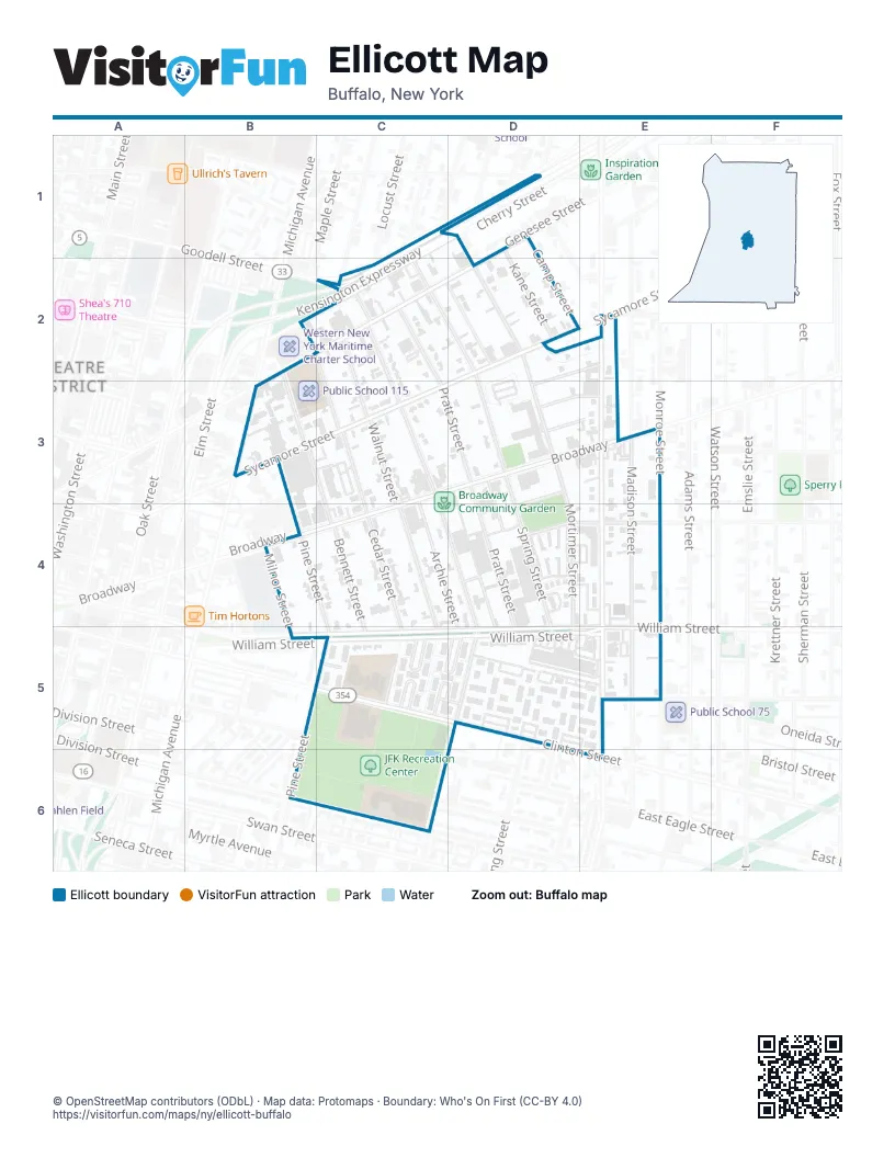
Street index of Ellicott
Each street on the sheet and the grid squares it crosses.
- Cherry StreetC1, C2
- Kensington ExpresswayC1, D1, C2
- Kane StreetD1, D2
- Ash StreetB2, B3, C4
- Genesee StreetB2, C2
- Spruce StreetB2, C2, C3, C4
- BFMC DriveC2
- Eureka PlaceC2, D2
- Goodell StreetC2
- Hickory StreetC2, C3, C4, D4, D5, C6
- Mulberry StreetC2
- Pratt StreetC2, C3, D3, D4, D5
- Spring StreetC2, D2, D3, D4, D5
- Walnut StreetC2, C3, C4, C5
- Mortimer StreetD2, D3, D4, D5
- Sycamore StreetD2, C3
- Sydni AlleyD2, E2
- Jefferson AvenueE2, E3, E4, E5, E6
- Matthews StreetE2, D3
- Cypress StreetB3
- North Pine StreetB3, B4
- Archie StreetC3, C4, D5
- BroadwayC3
- Castor AlleyD3, D4
- George StreetD3, E3
- Hollister StreetD3, D4
- Rey StreetD3, E3
- Milnor StreetB4, B5
- Pine StreetB4, B5, C5
- Bennett StreetC4, C5
- Cedar StreetC4, C5
- Iroquois PlaceD4, D5
- West Peckham StreetD4, E4
- Peckham StreetE4
- Clinton StreetB5, C5, E6
- East Eagle StreetB5
- Bedford CourtC5
- Cambridge CourtC5, D5
- Durham CourtC5
- Essex LaneC5
- Oxford CourtC5
- Sussex CourtC5, D5
- William StreetC5, D5, E5
- Byrd WayD5, E5
- Curry WalkD5
- Echols LaneD5
- McCarley WalkD5
- McNeeley WayD5
- Howard StreetE5
- Madison StreetE5
- North Division StreetC6
- South Division StreetC6
Places on the map
- Broadway Community Garden
- Clinton Junior High School
- Jefferson Street Heritage Gallery
- JFK Recreation Center
- McDonald's
- Pratt-Willert Community Center
- Public School 115
- Public School 47
- Public School 50
- Public School 6
- Saint Marys School
- Towne Gardens
- Towne Gardens Plaza
- Wende Park
- Willert Park
Next to Ellicott
- Theatre District
© OpenStreetMap contributors (ODbL) · Map data: Protomaps · Boundary: Who's On First (CC-BY 4.0)