

New York map
Elmwood Bidwell map
A printable two-page map of Elmwood Bidwell (Buffalo, New York), drawn by VisitorFun from OpenStreetMap. Page two is the street index: every street on the sheet with its grid square, the same list as below.
Open the map (PDF, US Letter)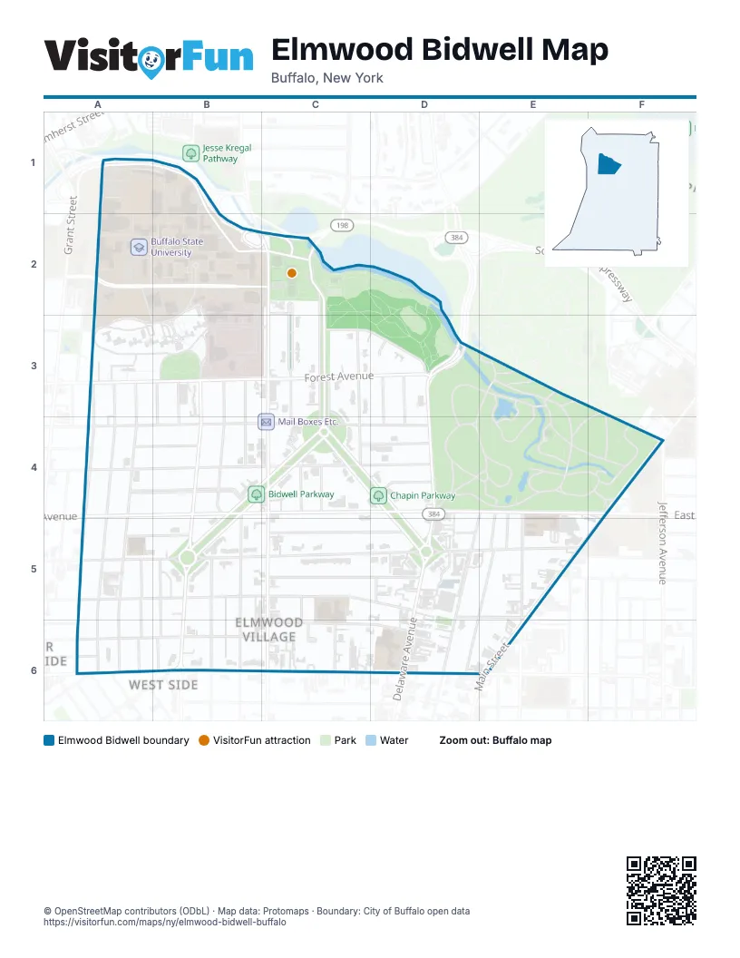
Street index of Elmwood Bidwell
Each street on the sheet and the grid squares it crosses.
- Iroquois DriveA1, B1, B2, C2
- Moore PlaceA1, B1
- Service Access RdA1, B1
- Scajaquada ExpresswayB1, B2, C2
- Academic DriveA2
- Bengal DriveA2
- Ketchum DriveA2, A3
- Rockwell RoadA2, B2, C2
- Union PlaceA2, B2
- Cleveland CircleB2
- Richardson RoadB2
- Elmwood AvenueC2, C4, C5, C6
- Lincoln ParkwayC2, C3, C4
- Penhurst ParkC2, C3
- Penhurst PlaceC2
- Baynes StreetA3, A4, A5, A6
- Forest AvenueA3, B3, C3, D3
- Hoyt StreetA3, A4, A5, A6
- Parkdale AvenueA3, A4, A6
- Abbotsford PlaceB3, B4
- Ashland AvenueB3, B4, B6
- Claremont AvenueB3, B4
- Hotel Henry WayB3
- Richmond AvenueB3, B4, B5, B6
- Tremont PlaceB3, B4
- Granger PlaceC3, C4
- Rumsey RoadC3, D3
- Soldiers CircleC3, C4
- Windsor AvenueC3, C4
- Berkley PlaceD3, D4
- Clarendon PlaceD3, D4
- Delaware AvenueD3, D4, D5, D6
- Rumsey LaneD3
- Bird AvenueA4, B4, C4, D4
- Dorchester RoadA4, B4
- Garner AvenueA4
- Manchester PlaceA4, B4
- Potomac AvenueA4, B4, C4, D4
- Bidwell ParkwayB4, C4, B5
- West Delavan AvenueB4, C4, D4, E4, F4
- Argyle ParkC4
- Brantford PlaceC4
- Chapin ParkwayC4, D4, D5
- Inwood PlaceC4, D4
- Lincoln Woods LaneC4
- Saybrook PlaceD4
- Harvard PlaceE4, E5, E6
- Horton PlaceE4, E5
- Linwood AvenueE4, D5, D6
- Oxford AvenueE4, E5, D6
- East Delavan AvenueF4
- Jefferson AvenueF4
- Main StreetF4, E5, E6
- Ardmore PlaceA5, B5
- Lafayette AvenueA5, B5, C5, D5, E5
- Putnam StreetA5, A6
- Auburn AvenueB5, C5, D5
- Colonial CircleB5
- Gill AlleyB5, B6
- Gren-Way AlleyB5, B6
- Livingston AlleyB5
- Livingston StreetB5, B6
- Norwood AvenueB5, B6
- Cleveburn PlaceC5, C6
- Lancaster AvenueC5, D5
- Saint James PlaceC5, D5
- Gates CircleD5
- Hoxsie LaneD5
- Linwood TerraceD5
- Melbourne CourtD5
- Melbourne PlaceD5
- West Balcom StreetD5, E5
- East Balcom StreetE5
- Florida StreetE5
- Masten AvenueE5
- Northland AvenueE5
- Arnold StreetA6
- Boyd StreetA6
- Breckenridge StreetA6, B6, C6
- South Putnam StreetA6
- Ferry CircleB6
- West Ferry StreetB6
- Brittany LaneC6
- Cleveland AvenueC6, D6
- Queen Anns GateC6
- Saint Catherines CourtC6
- Tudor PlaceC6
- Michigan AvenueE6
Things to do on the Elmwood Bidwell map
Places on the map
- 7-Eleven
- Aguacates Mexican Bar & Grill
- AKG Great Lawn
- Anna Grace Shop
- AT&T
- Atelier
- Autark Brewhouse
- Autark Brewhouse Taproom
- AutoZone
- Bark Avenue Pet Salon
- Bidwell Parkway
- Blue-Sky Mausoleum
- Breezy Burrito
- Brylin Hospital
- BUF Buffalo Airport taxi
- Buffalo AKG Art Museum
- Buffalo Auto Glass
- Buffalo Cultural Walk of Fame
- Buffalo History Museum - Resource Center
- Buffalo Psychiatric Center
- Buffalo Seminary
- Buffalo ShopCraft
- Buffalo State Ice Arena
- Buffalo State Performing Arts Center
- Buffalo State University
- Burchfield Penney Art Center
- Bureau
- Caffe Aroma
- Cameron's 24 Hour Store
- Canisius High School
- Canterbury Woods Gates Circle
- Chapin Parkway
- Charlie The Butcher's Carvery
- Cleveland Circle
- Cole's
- Colonial Circle
- Common Sky
- Congregation Beth Abraham
- Cookies & Cream
- Cornelia
Next to Elmwood Bidwell
© OpenStreetMap contributors (ODbL) · Map data: Protomaps · Boundary: City of Buffalo open data