

New York map
Genesee-Moselle map
A printable two-page map of Genesee-Moselle (Buffalo, New York), drawn by VisitorFun from OpenStreetMap. Page two is the street index: every street on the sheet with its grid square, the same list as below.
Open the map (PDF, US Letter)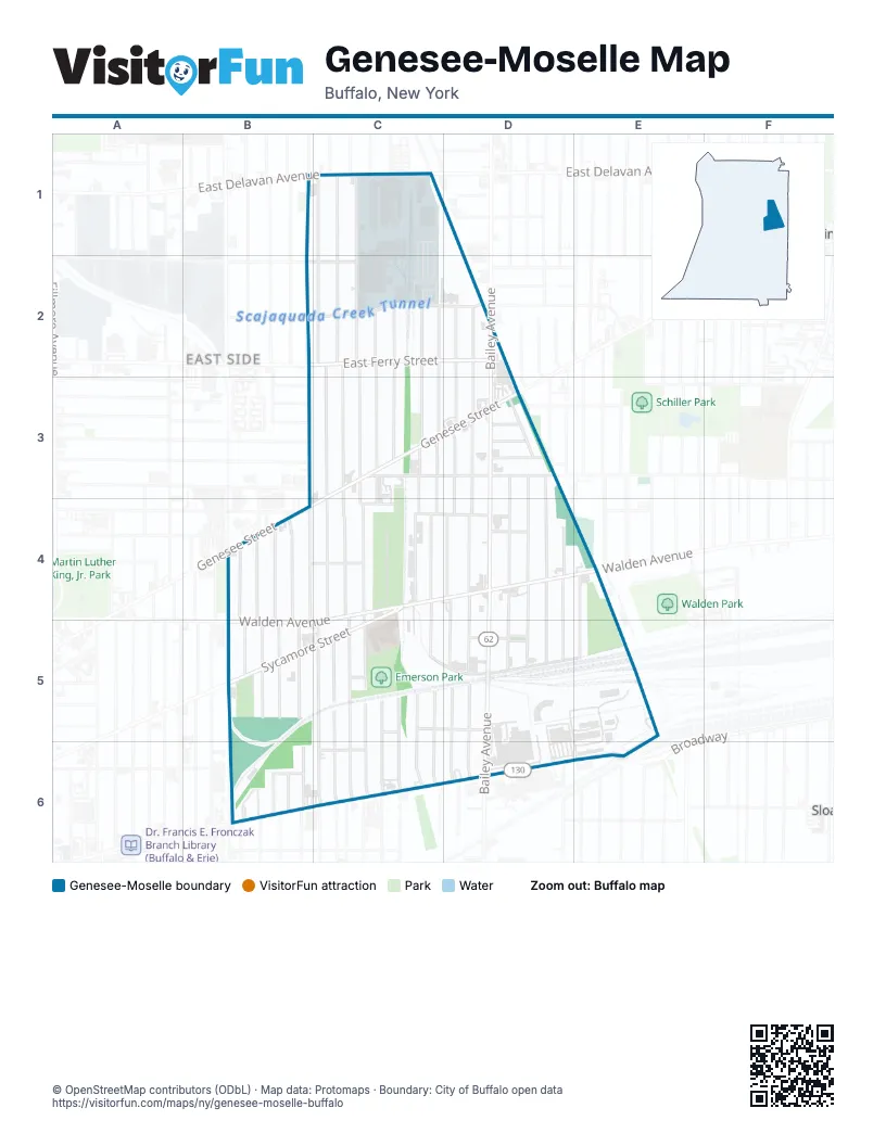
Street index of Genesee-Moselle
Each street on the sheet and the grid squares it crosses.
- East Delavan AvenueB1
- Wyoming AvenueB1, C1, C2
- Cambridge AvenueC1, C2
- Cornwall AvenueC1, C2
- Norfolk AvenueC1
- Northumberland AvenueC1, C2
- Moselle StreetB2, B3, B4, B5
- Northland AvenueB2, C2
- Bissell AvenueC2, C3, C4, C5
- Colorado AvenueC2, C3
- East Ferry StreetC2, D2
- Goodyear AvenueC2, C4
- Kilhoffer StreetC2, C3
- Leslie StreetC2, C3
- Montana AvenueC2, C3
- Nevada AvenueC2, C3
- Scajaquada StreetC2, D2
- Wende StreetD2, D3
- Zenner StreetD2, D3
- Box AvenueB3
- East Woodlawn AvenueB3
- Frankfort AvenueB3
- French StreetB3
- Hurlock AvenueB3
- Doat StreetC3, D3
- Genesee StreetC3, D3, B4, C4
- Koons AvenueC3, C4, C5, C6
- May StreetC3, C4, C5
- Rapin PlaceC3, C4
- Rustic PlaceC3, C4
- Antwerp StreetD3
- Bailey AvenueD3, D4, D5
- Boehm PlaceD3
- Brinkman AvenueD3, D4, D5
- Burgard PlaceD3, D4
- Goemble AvenueD3, D4
- Keystone StreetD3, D4
- Moeller StreetD3
- Rawlins AvenueD3
- Sumner PlaceD3, D4, D5
- Warring AvenueD3
- Barthel StreetB4, B5
- Fougeron StreetB4
- Ivy StreetB4, B5
- McKibben StreetB4, C4
- St Louis AvenueB4, B5
- Wasmuth AvenueB4, B5
- Goodyear StreetC4, C5, C6
- Hazel PlaceC4, D4
- Lansdale PlaceC4
- Sycamore StreetC4, B5
- Fay StreetD4, D5
- Keystone AvenueD4, D5
- Rohe StreetD4
- Saint Joseph AvenueD4, D5
- Walden AvenueD4, E4, B5
- Wood AvenueD4, D5
- Wex AvenueE4, E5
- Gittere StreetB5
- Howlett StreetB5
- Oberlin AvenueB5
- Ruhland AvenueB5
- Brier StreetC5
- Hirschbeck StreetC5, C6
- Liddell StreetC5, C6
- Miller AvenueC5, C6
- Pullman PlaceC5, D5
- Schutrum StreetC5, C6
- Titus AvenueC5, C6
- West Shore AvenueC5, D5, E5
- Wick StreetC5, C6
- Gatchell StreetD5, D6
- Scheu ParkD5
- Shepard StreetD5, D6
- Person StreetB6
- Rommel AvenueB6
- Schlenker StreetB6
- Schmarbeck AvenueB6
- Empire StreetC6
- BroadwayD6, E6
- Broadway StreetE6
Places on the map
- Apon Supermarket
- Beth Jacob Cemetery
- Community Food & Meat Market
- Concordia Cemetery
- Emerson Park
- Hank Nowak Park
- Harvey Austin School
- Kelly Gardens
Next to Genesee-Moselle
- East Side
- Sloan
© OpenStreetMap contributors (ODbL) · Map data: Protomaps · Boundary: City of Buffalo open data