

New York map
Grant-Amherst map
A printable two-page map of Grant-Amherst (Buffalo, New York), drawn by VisitorFun from OpenStreetMap. Page two is the street index: every street on the sheet with its grid square, the same list as below.
Open the map (PDF, US Letter)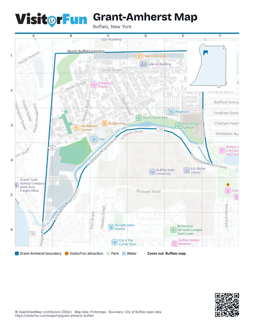
Street index of Grant-Amherst
Each street on the sheet and the grid squares it crosses.
- Joslyn PlaceB1, B2
- Chandler StreetC1, E1
- Germain StreetC1, C2, C3
- Grote StreetC1, E1, F1
- Howell StreetC1, D2, D3
- Lansing StreetC1, B2
- Military RoadC1, B2, C2, B3
- Peter StreetC1, C2, D3
- Bridgeman StreetD1, D2
- Bush StreetD1, D2
- Manton PlaceD1
- Reservation StreetD1, D2
- Elmwood AvenueF1, F2, F3, F4
- Austin StreetB2, C2
- Clay StreetB2, B3
- Glor StreetB2, B3
- Grant StreetB2, C2, C3
- Kail StreetB2, B3
- Amherst StreetD2, E2, B3, C3, A4, B4
- Marion StreetD2, E2, F2
- Beaumaris PlaceE2, E3
- Woodette PlaceE2, F2
- Bedford AvenueF2
- Elmhurst PlaceF2
- Great Arrow AvenueF2
- Churchill StreetB3
- Scajaquada ExpresswayC3, D3, E3, B4, C4, E4, F4, B5, A6, B6
- Elmview PlaceE3, F3
- Chatham AvenueF3
- Middlesex RoadF3
- Tonawanda StreetA4, B4, A6
- Watts StreetA4, B5
- Nottingham TerraceF4
- West AvenueA5, B5, B6
- Niagara StreetA6
Places on the map
- Amherst Street Wine & Liquor
- Boys & Girls Clubs of the Northtowns Black Rock Assuption Club
- Burger King
- Charity Baptist Church
- Church of the Assumption of the Blessed Virgin Mary
- Hot Mama’s Canteen
- Jesse Kregal Pathway
- KeyBank
- Linde Air Building
- McKinley High School
- Peters Street Park
- Showplace Theater
- Tappo Day Club
- Tops
- US Hames Company Site
- Wegmans
Next to Grant-Amherst
- North Buffalo Junction
© OpenStreetMap contributors (ODbL) · Map data: Protomaps · Boundary: City of Buffalo open data