

New York map
Huntington map
About 204,706 people live here (Census Bureau, 2024 estimate). The sheet's index lists 300 streets; Long Island Expressway, North Service Road and Eatons Neck Road cross the most grid squares. Things to do inside the boundary: Caumsett State Historic Park Preserve, Heckscher Park and Oheka Castle.
Open the map (PDF, US Letter)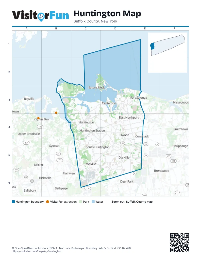
Street index of Huntington
Each street on the sheet and the grid squares it crosses.
- Northern State ParkwayC5, D5, E5
- Long Island ExpresswayC5, D5, E5, C6
- New York AvenueC3, C4, C5
- Walt Whitman RoadC5, C6
- Deer Park AvenueD5, D6
- Broadhollow RoadC5, C6
- Fort Salonga RoadD3, E3
- East Jericho TurnpikeD4, C5, D5
- Commack RoadE4, E5, E6
- Main StreetD3, C4
- East Main StreetD3, C4, D4
- Jericho TurnpikeD4, E4, C5
- Round Swamp RoadC5, C6
- Harbor RoadB4, C4
- West Jericho TurnpikeC5
- Deer Park RoadD5
- West Main StreetC4
- East Deer Park RoadD4, D5
- Northern BoulevardB4, C4
- South Service RoadD5, E5, C6
- North Service RoadC5, D5, E5, C6
- Old Country RoadC5, D5, E6
- Park AvenueC4, D4, D5
- Pulaski RoadD4, E4
- Vanderbilt ParkwayD5, E5
- Larkfield RoadD4, E4, E5
- Half Hollow RoadC5, D5, C6
- Elwood RoadD3, D4
- Pinelawn RoadC5, C6
- BroadwayC4, D4
- Oakwood RoadC4, C5
- Woodbury RoadC4
- East Pulaski RoadC4, D4
- Cuba Hill RoadD4
- Eatons Neck RoadC2, D2, C3, D3
- Daly RoadD4, E4, E5
- Waterside RoadD3
- West Pulaski RoadC4
- Greenlawn RoadC4, D4
- Townline RoadE4
- Lawrence Hill RoadC4
- Bread and Cheese Hollow RoadE3
- Vernon Valley RoadD3, D4
- Ruland RoadC6
- Ocean AvenueD3
- Nassau RoadC4
- Laurel RoadD3, D4
- Spring RoadC4
- Centerport RoadD3, D4
- James StreetD3, C4, D4
- Spagnoli RoadC6
- Church StreetD3, C4
- Seamans Neck RoadD6
- Colonial Springs RoadC6
- Laurel AvenueD3
- Crooked Hill RoadC4, E5
- Woodbine AvenueD3
- Old Northport RoadC4, D4, E4
- Bayview AvenueD3
- Reservoir AvenueD3
- Republic RoadC6
- High StreetC4
- Prime AvenueC4
- Town Line RoadE4
- Sabbath Day PathC4
- New HighwayE5, C6
- Avery RoadC5
- Straight PathD6
- Little East Neck RoadC6
- Express Drive SouthE5
- West Neck RoadB3, C3, C4
- Clay Pitts RoadD4, E4
- Wolf Hill RoadC5, D5
- 5th AvenueD3, C4, D4, E4
- Sweet Hollow RoadC5
- Carlls Straight PathD5, E5, E6
- Lloyd Harbor RoadB3, C3
- Asharoken AvenueD2, D3
- Maxess RoadC6
- Burr RoadD4, E4
- Cedar RoadD4, E4
- West Hills RoadC4, C5
- Stony Hollow RoadD3, D4
- Little Neck RoadD3
- Burrs LaneD5, D6
- Bagatelle RoadD5, D6
- Dix Hills RoadD4, D5
- Little Plains RoadD4
- Caledonia RoadD5
- Wilmington DriveC6, D6
- Depot RoadC4, C5, D5
- Bellerose AvenueD4, E4
- West Shore RoadC3, C4
- Huntington Bay RoadC3, C4
- Pidgeon Hill RoadD5
- Middleville RoadD3, E3
- Village Hill DriveE5
- Manor RoadD4, D5
- Cove RoadD2, C3, D3
- Deforest RoadD5
- Old Bridge RoadE3, E4
- Lenox RoadC4
- Ryder AvenueD5, D6
- West Rogues PathC4
- Maplewood RoadC4, D4
- East Rogues PathC4, D4
- Makamah RoadE3
- Mill Dam RoadC3, D3, C4
- Carman RoadD5
- Baylis RoadC6
- Warner RoadD4, D5
- Kenneth AvenueD4
- Norwood RoadD3, E3
- Scudder AvenueD3
- West 11th StreetC4
- Hauppauge RoadE5
- Old South PathC5, D5
- Norwood AvenueD3
- Stoothoff RoadE4
- Duryea RoadC6
- Northcote DriveC6, D6
- Cold Spring Hills RoadC4, C5
- Turkey LaneC4
- East 11th StreetC4
- Pine Hill LaneE5
- Marcus DriveC6
- Wall StreetC4
- Dix HighwayE5
- Manor Road NorthD4
- Old Walt Whitman RoadC5
- Carnegie AvenueC4
- Rinaldo RoadE3
- Clinton AvenueC4
- Deshon DriveC6
- Mill LaneC4
- Youngs Hill RoadC3
- Corporate Center DriveC6
- Gerard StreetC4
- South Hollow RoadD5, D6
- Madison StreetD3, C4
- Nathan Hale DriveC4
- Wren CourtE4
- Target Rock RoadC3
- Asharoken RoadD2
- Green StreetC4
- Schwab RoadC5
- New StreetC4
- Conklin AvenueD6
- Union PlaceD3, C4
- Stewart AvenueC4
- Havemeyer LaneE4
- Southdown RoadC3, C4
- Altessa BoulevardC5, D5
- Old East Neck RoadC5, C6
- Vineyard RoadC3, C4
- Washington DriveD3, C4, D4
- Bay AvenueC3
- Melville RoadC4, C5
- Candlewood PathD5, E5
- Railroad StreetC4, D4
- Lloyd LaneB3
- West 22nd StreetC5
- Madeira BoulevardC5, D5
- Fiddlers Green DriveC2, C3
- Beverly RoadD4, D5
- Mount Misery RoadC5
- Flower Hill RoadC3, C4
- Jennings RoadC3, B4, C4
- Lake RoadD4
- Laurel Hill RoadD3, D4
- Old Brook RoadE5
- Locust LaneD2, C3, D3
- Doctor Frank A Cipriani DriveC6
- Stonehurst LaneE5
- Millet StreetD5, D6
- Dunlop RoadC4, D4
- Harbor Hill DriveC3
- Buttonwood DriveD5
- 3rd AvenueC4, D4
- East Shore RoadC3
- 4th AvenueC4, D4
- Chichester RoadC5
- Canon ParkC6
- Cedrus AvenueE4
- East 17th StreetC4, D4
- Court North DriveC6
- School LaneB3, C3, D4
- Harrison DriveD3
- Wicks RoadE5
- Wildwood DriveD5, D6
- Beaumont DriveD5, D6
- McCulloch DriveE5
- Oldfield RoadD4
- 10th AvenueC4, D4
- 9th AvenueC4, D4
- Threepence DriveD5, D6
- Woodhull RoadC4
- Fleets Cove RoadD3
- Westminster AvenueD5, D6
- East 5th StreetC4
- Lighthouse RoadC2, D2
- Shore RoadB4, C4
- Huntington Cemetery Service RoadC4
- Salem Ridge DriveD4
- Station WayC4
- Lisa DriveD3, D5
- Camel Hollow RoadB3, C3
- Godfrey LaneD4
- Prospect RoadD3
- Forrest DriveC2, C3
- Sandy Hollow RoadD3, D4
- Lauren AvenueE5
- Hunting Hill DriveD5
- Farmington LaneD6
- Arbor LaneD5
- Bay RoadC3
- Landview DriveD5
- Hearthstone DriveD5, E5
- Duck Island LaneD3
- Medical CircleE3
- Roundtree DriveD5, D6
- Hartman Hill RoadC5
- Fresh Pond RoadE3
- White Hill RoadB4, C4
- Mc Kay RoadC4
- Colonial DriveC5
- Wells RoadD4
- Paumanack Village DriveD4
- Turtle Cove LaneC4
- Truxton RoadD6
- Iceland DriveC5
- Lodge AvenueD4
- Old Town LaneC3
- West 21st StreetC5
- Randolph DriveE5
- Whitson RoadC4, D4
- Meadowdale DriveC5
- Alpine WayD4, D5
- Fox LaneD3, D5
- West 19th StreetC4, C5
- Darrow LaneD4
- Louis DriveC5
- Catherine StreetD3, D4
- Terrace DriveE3, C4
- Colby DriveE5
- Forest DriveD3, E3, D4, E4
- Winkle Point DriveC2, C3
- Rustic GateD5, D6
- Rivendell CourtC5, C6
- Longacre DriveC4, D4
- Greenmeadow LaneC4, C5
- Mc Kinley TerraceD3
- East 23rd StreetC5
- Fort Hill DriveB3
- Mallard DriveB3
- Middle Hollow RoadC3, C4
- Highland AvenueD3, D5
- South Ketay DriveE4
- Melrose RoadD5
- Talisman DriveD5
- Goosehill RoadC3, C4
- 4th StreetD4
- Oakfield AvenueD5, D6
- Foothill LaneD4, E4, D6
- Phaetons DriveC5
- Wyoming DriveC4, D4
- Lincoln AvenueD3, E5
- Villanova LaneD5
- Woodmont RoadD6
- East 13th StreetC4
- Stratford AvenueD4, D5, D6
- 11th AvenueC4, C5
- Butterfield DriveD4
- 2nd AvenueC4, D4
- Snake Hill RoadB4
- Soundview RoadC4
- Briarfield LaneC4
- East Neck RoadC3, D3
- Woodedge DriveD5
- Brand DriveD4
- Bevin RoadD2
- Verona DriveC5, D5
- Wagon Wheel LaneE5
- Legends CircleC6
- Majestic DriveD5
- Plover LaneB3, C3
- Mannetto Hill RoadC5
- Baldwin PathD5, D6
- East 12th StreetC4
- Fox Hollow Ridings RoadD3, E3
- Target Rock DriveC2, C3
- Saw Mill RoadC4
- Norton DriveD3, E3
- Timber Ridge DriveD4
- Colonial StreetD4, E4
- Cherry LaneD4
- East Gate DriveC5
- Steers AvenueD3
- Hunting Hollow CourtD5, D6
- Quintree LaneC5, D5
Things to do on the Huntington map
Places on the map
- 110 Sand Pit
- Asharoken Beach
- Berkeley Jackson County Park
- Caumsett
- Centerport
- Cold Spring Country Club
- Cold Spring Harbor
- Crab Meadow
- Crab Meadow Golf Course
- Dix Hills
- Dix Hills Park
- East Northport
- Eatons Neck
- Elwood
- Greenlawn
- Halesite
- Hobart Beach Park
- Huntington Country Club
- Huntington Crescent Club
- Huntington Quadrangle
- Huntington Station
- Indian Hills Country Club
- Knolls Park
- Knutson Marine
- Makamah County Nature Preserve
- Mannetto Hills
- Marshall Field
- Meadowlark Park
- Melville
- New York State Land
- Northport Veterans Hospital
- Pineridge Park
- South Huntington
- The Greens at Half Hollow
- Uplands Farm Sanctuary
- Valley Grove Beach
- Village of Asharoken
- Village of Huntington Bay
- Village of Lloyd Harbor
- Village of Northport
Next to Huntington
- Bayville
- Baywood
- Bethpage
- Brentwood
- Deer Park
- Hauppauge
- Hicksville
- Jericho
- Laurel Hollow
- Mill Neck
- New Cassel
- Nissequogue
- Oyster Bay
- Plainview
- Salisbury
- Smithtown
- Syosset
- Upper Brookville
- Village of the Branch
- Wheatley Heights
- Woodbury
- Wyandanch
© OpenStreetMap contributors, Open Database License, openstreetmap.org/copyright · Map data: Protomaps · Boundary: Who's On First (CC-BY 4.0)