

New York map
Latourette Park map
A printable two-page map of Latourette Park (Staten Island, New York), drawn by VisitorFun from OpenStreetMap. Page two is the street index: every street on the sheet with its grid square, the same list as below.
Open the map (PDF, US Letter)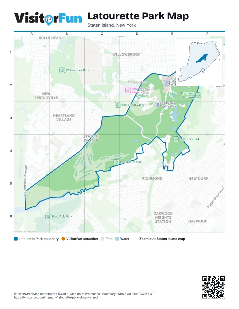
Street index of Latourette Park
Each street on the sheet and the grid squares it crosses.
- Manor RoadE1, E2, E3, E4
- Ocean TerraceE1, F1
- Peru StreetE1, E2
- Portage AvenueE1
- Foster AvenueF1
- Marshall AvenueF1
- Auerbach LaneD2
- Brielle AvenueD2, E2, D3
- Coryllos LaneD2, D3
- County House RoadD2
- Friendship LaneD2
- Greenberger LaneD2, E2
- Ornstein LaneD2, D3
- Roanoke StreetD2
- Scmick LaneD2, E2
- Selikoff LaneD2, E2
- Bucky DriveE2, D3
- Pitt AvenueE2, F2
- Blackhorse AvenueF2
- Bogert AvenueF2
- Browning AvenueF2
- Cliffwood AvenueF2
- Romier RoadF2
- Todt Hill RoadF2
- Willow Pond RoadF2
- Forest Hill RoadC3, B4, C4, A5, B5
- Gwenn LoopC3
- Rockland AvenueC3, D3, D4, E4
- Pierpont PlaceB4
- Richmond Hill RoadB4, C4, C5
- Rumson RoadB4, B5
- Stone LaneB4
- Leason PlaceC4
- London RoadC4, D4, C5
- Esther Depew StreetD4
- Lowell StreetD4
- Meeker StreetD4
- Meisner AvenueD4
- Scheffelin AvenueD4
- Winsor AvenueD4
- Beacon AvenueE4
- Boyle StreetE4
- Chance AvenueE4
- Di Marco PlaceE4, E5
- Elvira CourtE4
- Enfield PlaceE4, E5
- Kayla CourtE4
- Luigi CourtE4
- Milburn StreetE4
- Nevada AvenueE4
- Nugent StreetE4
- Sloane AvenueE4
- Summit AvenueE4
- Tonking RoadE4
- Walden AvenueE4
- Alaska PlaceA5
- Independence AvenueA5
- Richmond AvenueA5, A6
- Yukon AvenueA5
- Platinum AvenueB5
- Edinboro RoadC5
- Old Mill RoadC5
- Rigby AvenueC5
- Dorothea PlaceE5
- Morley AvenueE5
- Richmond RoadE5
Places on the map
- A Cemetery for All God's Creatures
- Altamont Pond
- Brielle Avenue & Mountainview Avenue
- Brielle Avenue & Roanoke Street
- Buck’s Hollow
- Greenbelt Nature Center
- Greenbelt Outdoor Classroom
- Henry Kaufmann Campgrounds
- Heyerdahl Ruins
- High Rock Park
- La Tourette Golf Course
- La Tourette Park
- LaTourette Park Model Aircraft Field
- Loosestrife Swamp
- Men's Open-air Pavilions
- Native Rhododendron Garden
- Ohrback Lake
- Ornstein Lane
- Our Lady of Zeitoun Coptic Orthodox Church
- Pathology Laboratory
- Paulo’s Peak
- Priory Pond
- Pump House Pond
- Richmond Town Estates
- Saint Andrews Church
- Saint Francis Woodlands
- Sea View Adult Day Care Center
- Sea View Playwrights Theatre
- SeaView
- Seaview Hospital & Dr. E. Robitzek Building
- Seaview Hospital & Park Lane
- Seaview Hospital Entrance & Traffic Loop
- Seaview Hospital Exit & Traffic Loop
- Sensory Friendly Playground
- St. Anne
- St. Anthony
- St. Mary's Christian Center
- Staten Island Ballet
- Staten Island Scout Shop
- Stump Pond
Next to Latourette Park
- Bulls Head map
- Heartland Village
- New Dorp map
- New Springville
- Oakwood map
- Oakwood Heights Station
- Richmond
- Staten Island map
- Todt Hill map
- Willowbrook
© OpenStreetMap contributors (ODbL) · Map data: Protomaps · Boundary: Who's On First (CC-BY 4.0)