

New York map
Little Neck map
A printable two-page map of Little Neck (Queens, New York), drawn by VisitorFun from OpenStreetMap. Page two is the street index: every street on the sheet with its grid square, the same list as below.
Open the map (PDF, US Letter)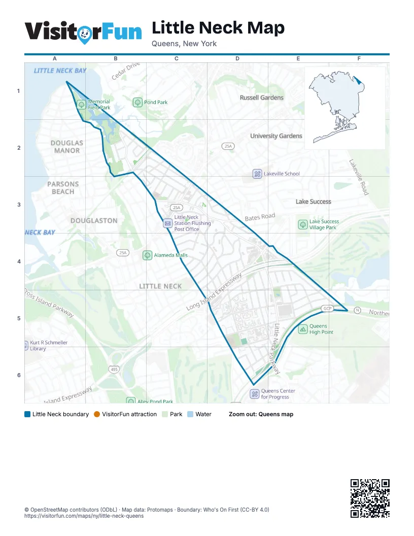
Street index of Little Neck
Each street on the sheet and the grid squares it crosses.
- Kenmore RoadA1
- Knollwood AvenueA1
- Marinette StreetA1, A2
- Warwick AvenueA2
- 254th StreetB2, C3, D4, D5, D6, E6
- 255th StreetB2, D4, D5, E5, E6
- 34th AvenueB2
- 37th AvenueB2
- 38th AvenueB2
- 39th AvenueB2
- 39th RoadB2, C2
- 40th AvenueB2, C2
- Brookside StreetB2
- Douglas RoadB2
- Glenwood StreetB2, C2, C3, D3
- Little Neck ParkwayB2, B3, C3, D3, D4, E4, E5, E6
- Park LaneB2
- Ridge RoadB2
- Sandhill RoadB2
- Westmoreland StreetB2, C2, C3
- 41st AvenueC2, B3
- 41st DriveC2, C3
- Cutter AvenueC2
- Morgan StreetC2, C3
- Nassau RoadC2
- Summit AvenueC2
- West Mill DriveC2
- 41st RoadB3, C3
- 251st StreetC3, D4, D5, D6
- 42nd AvenueC3
- 43rd AvenueC3
- 44th AvenueC3
- Annadale LaneC3, D3, C4
- Beechknoll AvenueC3
- Browvale LaneC3, C4, D4
- Cornell LaneC3
- Deepdale PlaceC3, C4
- Gaskell RoadC3, C4
- Hand RoadC3
- Iowa RoadC3, D3
- Jessie CourtC3
- Marathon ParkwayC3, C4, D5
- Northern BoulevardC3
- Pembroke AvenueC3
- Van Nostrand CourtC3
- West End DriveC3
- 52nd RoadD3
- Bates RoadD3
- Brattle AvenueD3, D4
- Concord AvenueD3
- Concord StreetD3, D4
- Highland PlaceD3
- Leith RoadD3, D4
- Oakley PlaceD3
- Upland RoadD3
- Walden AvenueD3
- 250th StreetC4, D5
- 51st AvenueC4, D4
- 52nd AvenueC4, D4
- Cambria AvenueC4
- Deepdale AvenueC4
- Morenci LaneC4, D4, D5
- Rushmore TerraceC4
- Thebes AvenueC4, D4
- Thornhill AvenueC4, D4
- Van Zandt AvenueC4, D4
- 251st PlaceD4
- 252nd StreetD4, D5, D6
- 253rd StreetD4, D5, D6
- 256th StreetD4, D5, E5
- 260th StreetD4, E4, E5
- 57th AvenueD4, E4, D5
- Horace Harding BoulevardD4
- Horace Harding ExpresswayD4, E4, D5
- Leeds RoadD4
- Leith PlaceD4
- Long Island ExpresswayD4, E4, D5
- Nassau BoulevardD4
- Overlook RoadD4
- 262nd StreetE4, E5
- 263rd StreetE4, E5
- 264th StreetE4, E5
- 58th AvenueE4, D5
- 60th AvenueE4, D5, E5
- Fairway DriveE4
- Hewlett StreetE4, E5, F5
- South Service RoadE4
- 61st AvenueD5, E5, F5
- 63rd AvenueD5, E5, D6
- 64th AvenueD5, D6
- 59th AvenueE5
- 60th RoadE5
- 62nd AvenueE5
- Grand Central ParkwayE5, F5, D6, E6
- Northern State ParkwayF5
- Cullman AvenueD6, E6
Places on the map
- Admiral Park
- Afridi's Halal Food
- Bean & Bean Coffee
- Benjamin Moore
- BP
- Brandywine at the Savoy
- Castle Chicken
- Challenge Playground
- Christ Evangelical Lutheran Church
- Commonpoint Queens
- Community Church of Little Neck
- Douglaston RCAG
- Duane Reade
- Eun Chong Bible Presbyterian Church
- Fern & Aurora
- Five Guys
- Glenwood Landing
- Green Tree Construction, Inc
- Harvest Church of New York
- Horace Harding Expressway & 251st Street
- Horace Harding Expressway & Little Neck Parkway
- Horace Harding Expressway & Marathon Parkway
- Jian Chinese Restaurant
- Korean Joong Bu Church
- Little Neck
- Little Neck Jewish Center
- Little Neck Parkway & 255th Street
- Little Neck Parkway & 43rd Avenue
- Little Neck Parkway & 58th Avenue
- Little Neck Parkway & 61st Avenue
- Little Neck Parkway & Grand Central Parkway Service Road
- Little Neck Parkway & Horace Harding Expressway
- Little Neck Parkway & Nassau Boulevard
- Little Neck Parkway & Northern Boulevard
- Little Neck Plaza
- Little Neck Station Flushing Post Office
- McDonald's
- Memorial Field Park
- Nassau Mall
- Nassau Mall South
Next to Little Neck
- Belgrave Square
- Douglas Manor
- Douglaston map
- Lake Success
- Parsons Beach
- Russell Gardens
- Russell Woods
- Spinney Hill
- University Gardens
© OpenStreetMap contributors (ODbL) · Map data: Protomaps · Boundary: Who's On First (CC-BY 4.0)