

New York map
Long Island City map
A printable two-page map of Long Island City (Queens, New York), drawn by VisitorFun from OpenStreetMap. Page two is the street index: every street on the sheet with its grid square, the same list as below.
Open the map (PDF, US Letter)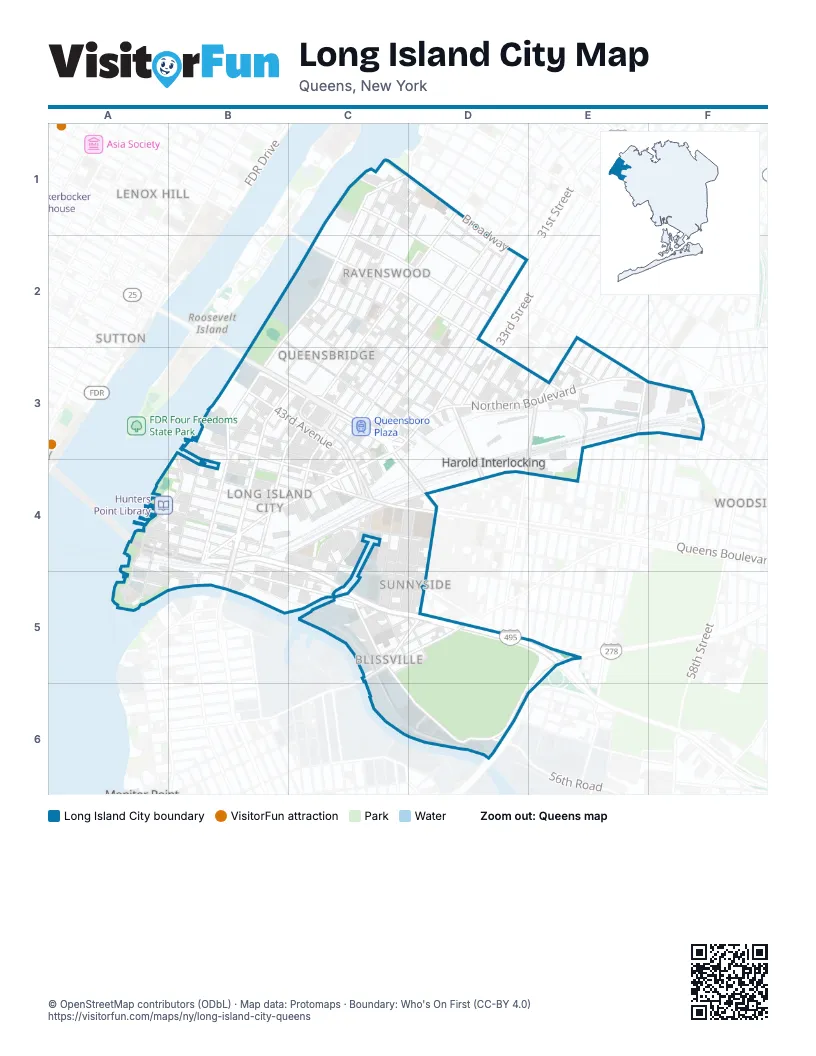
Street index of Long Island City
Each street on the sheet and the grid squares it crosses.
- 10th StreetC1, C2, B3, C3, B4
- 11th StreetC1, D1, C2, B3, C3, B4, B5
- 12th StreetC1, D1, C2, B3, C3
- 13th StreetC1, D1, C2, B3, C3
- 33rd AvenueC1, D1, D2
- 33rd RoadC1, D1, D2
- 34th AvenueC1, D1, D2, E3
- 35th AvenueC1, C2, D2, E3
- 9th StreetC1, C2, B3
- BroadwayC1, D1, D2
- Vernon BoulevardC1, B2, C2, B3, B4, B5
- 14th StreetD1, C2, D2
- 21st StreetD1, C2, B3, C3, B4, B5
- 23rd StreetD1, C2, D2, C3, B4, C4, B5
- 41st AvenueB2, C2, C3, D3
- 22nd StreetC2, D2, C3
- 24th StreetC2, D2, C3, C4
- 36th AvenueC2, D2, E3
- 37th AvenueC2, D3, E3
- 38th AvenueC2, D3, F3
- 39th AvenueC2, C3, D3, E3
- 40th AvenueC2, C3, D3
- Roosevelt Island BridgeC2
- 27th StreetD2, C3, C4, C5
- 28th StreetD2, C3, D3, C4
- 29th StreetD2, C3, D3, C4, C5
- 31st StreetD2, D3, D4, C5
- Crescent StreetD2, C3, D3, C4
- 41st RoadB3, C3
- 43rd AvenueB3, C3, C4, D4
- 43rd RoadB3
- 44th AvenueB3, C3
- 44th DriveB3, C4
- 44th RoadB3, C4
- 45th AvenueB3, B4, C4
- 5th StreetB3, B4
- Center BoulevardB3, A4, B4, A5
- Ed Koch Queensboro Bridge Lower LevelB3
- Ed Koch Queensboro Bridge Upper LevelB3, C3, C4
- North Basin RoadB3, B4
- Queens Plaza SouthB3, C3
- Queensboro Bridge (Lower Level)B3, C3
- Queensboro Bridge (Upper Level)B3, C3
- 40th RoadC3, D3
- 42nd RoadC3, C4
- Ed Koch Queensboro Bridge Lower RoadwayC3
- Hunter StreetC3, C4
- Jackson AvenueC3, B4, C4
- Northern BoulevardC3, D3, E3, F3
- Queens BoulevardC3, C4, D4
- Queens Plaza NorthC3
- Queensboro PlazaC3
- 30th StreetD3, C4, C5
- 32nd StreetD3
- 33rd StreetD3
- 34th StreetD3, C5, D5
- 35th StreetD3, C5, D5
- 36th StreetD3
- 37th StreetD3, C5, D5
- 38th StreetD3, E3
- Honeywell StreetD3, D4
- Old Ridge RoadD3
- Standard LaneD3
- 39th StreetE3, D4
- 41st StreetE3
- 42nd PlaceE3
- 42nd StreetE3
- 43rd StreetE3, E4
- 44th StreetE3
- 45th StreetE3
- 46th StreetE3
- 47th StreetE3
- 48th StreetE3
- Barnett AvenueE3, F3
- Steinway StreetE3
- 37th RoadF3
- 49th StreetF3
- 50th StreetF3
- 52nd StreetF3
- Newtown RoadF3
- Woodside AvenueF3
- 2nd StreetA4, A5
- 47th RoadA4, B4
- 48th AvenueA4, B4, C4
- 49th AvenueA4, B4, C4
- 50th AvenueA4, B4, C5
- 51st AvenueA4, B4, B5, C5
- 54th AvenueA4, B5, D6
- Borden AvenueA4, B4, C5, D5
- Queens-Midtown TunnelA4, B4
- 11th PlaceB4
- 45th RoadB4, C4
- 46th AvenueB4, C4
- 46th RoadB4
- 47th AvenueB4, C4
- Long Island ExpresswayB4, C4, C5, D5, E5
- Pulaski BridgeB4, B5
- 25th StreetC4, C5
- 30th PlaceC4, C5
- Austell PlaceC4
- Court Square EastC4
- Court Square WestC4
- Crane StreetC4
- Davis CourtC4
- Davis StreetC4
- Dutch Kills StreetC4
- Hunters Point BridgeC4, C5
- Orchard StreetC4
- Pearson PlaceC4
- Pearson StreetC4
- Purves StreetC4
- Queens StreetC4
- Skillman AvenueC4, D4
- Thomson AvenueC4, D4
- 31st PlaceD4, C5, D5
- 32nd PlaceD4
- Van Dam StreetD4, C5, D5
- 55th AvenueA5
- 56th AvenueA5
- 57th AvenueA5
- Malt DriveA5
- 53rd AvenueB5
- Bradley AvenueC5, D5
- Greenpoint AvenueC5, D5
- Hunters Point AvenueC5, D5
- Railroad AvenueC5, C6, D6
- Review AvenueC5, C6, D6
- Saint Thomas AvenueC5, D5, D6
- Starr AvenueC5, D5
- Boundary AvenueD5, E5
- Cathedral AvenueD5
- Gale AvenueD5
- Saint John's AvenueD5, D6
- Saint Mary's AvenueD5, D6
- Saint Peter AvenueD5
- Saint Rose AvenueD5, D6
- Saint Stephen's AvenueD5
- Brooklyn-Queens ExpresswayE5, E6
- Calvary AvenueE5, D6
- 54th RoadD6
- 56th RoadD6
- Cardinal Farley AvenueD6
- Laurel Hill BoulevardD6
- Locust AvenueD6
- Saint Calixtus AvenueD6
- Saint Jerome AvenueD6
Places on the map
- 108th Precinct Police Station
- 21st Street (G)
- 21st Street–Queensbridge
- 36th Street
- 39th Avenue
- 7-Eleven
- Access Self Storage
- Aloft
- Amalgamated Bank
- American Taximeters & Communications
- B&B Sheet Metal
- Bank of Manhattan Company Building
- Baymont
- BJ's Wholesale Club
- Bonoful Grocery
- Borden Avenue Veterans Residence
- BP
- Bravo
- Bridgeview School of Fine Arts
- Capitol Glass & Sash Co., Inc
- Central Parking System of New York, Inc.
- City Acres Market
- City Mailroom
- City View Inn
- Comfort Inn
- Community Church of Astoria
- Costco
- Court Square
- Court Square–23rd Street
- CubeSmart
- CUNY School of Law
- Dutch Kills Playground
- East Side Access
- Eplus Auto Group
- Evangel Church
- Extra Space Storage
- Fairfield Inn
- Fairfield Inn Long Island City/Manhattan View
- FDNY Engine 258/Ladder 115
- FDNY L116
Next to Long Island City
- Beekman
- Lenox Hill
- Roosevelt Island map
- Sunnyside Gardens
- Sutton
- Woodside map
© OpenStreetMap contributors (ODbL) · Map data: Protomaps · Boundary: Who's On First (CC-BY 4.0)