

New York map
Lovejoy map
A printable two-page map of Lovejoy (Buffalo, New York), drawn by VisitorFun from OpenStreetMap. Page two is the street index: every street on the sheet with its grid square, the same list as below.
Open the map (PDF, US Letter)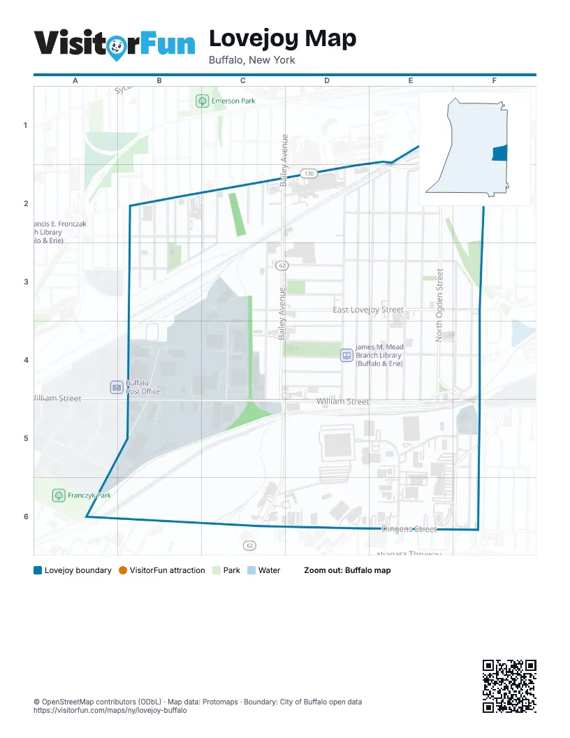
Street index of Lovejoy
Each street on the sheet and the grid squares it crosses.
- BroadwayE1, B2, C2, D2, E2
- Broadway StreetE1, E2
- North Ogden StreetE1, E2, E3, E4, E5
- Old BroadwayE1
- Goethe StreetF1, F2, F3, F4
- Schiller StreetF1, F2, F3, F4
- Ashley StreetB2, C2
- Goodyear StreetB2
- Koons AvenueB2
- Krupp AvenueB2, B3
- Miller AvenueB2
- Peck StreetB2, B3
- Person StreetB2, B3
- Quincy StreetB2, B3
- Rommel AvenueB2
- Swinburne StreetB2, B3
- Titus AvenueB2
- Armbruster StreetC2
- Bailey AvenueC2, C3, C4, C5, C6
- Brownell StreetC2, C3
- Central AvenueC2, C3, C5
- Deshler StreetC2, C3
- Gatchell StreetC2
- Hirschbeck StreetC2
- Jerome StreetC2
- Liddell StreetC2
- North Central AvenueC2
- Schutrum StreetC2
- Shepard StreetC2
- Stone StreetC2, D2
- Wick StreetC2
- Greene StreetD2, D3, D5
- King StreetD2, E2
- Longnecker StreetD2, D3, D5
- Reiman StreetD2, E2
- Benzinger StreetE2, E3, E5
- Davey StreetE2, E3, E5
- Gold StreetE2, E3, E5
- Ideal StreetE2, E3, E5
- Amity StreetB3, C3
- Grimes StreetB3
- East Lovejoy StreetC3, E3
- Lannette StreetC3
- Moreland StreetC3, D3
- Regent StreetC3, D3
- Stanley StreetC3, D3
- Vanderbilt StreetD3, F3
- Goethe LoopF3
- Msgr Valente DriveB4, B5
- Bogardus StreetC4, D4
- Bud Military DriveC4, C5
- Chauncey StreetC4, D4
- Dempster StreetC4, D4
- Hennepin StreetC4, D4
- Ludington StreetC4, D4, E4, F4
- William StreetE4, F4, B5, C5, D5, E5, F5
- Queen StreetF4, E5
- New Babcock StreetB5
- James E Casey DriveD5, E5, E6
- Thielman DriveE5, F5
- Bismarck StreetF5
- Cambria StreetF5
- Gardon StreetF5
- Richard DriveF5
- South Ogden StreetF5, F6
- Dingens StreetD6, F6
- Old South Ogden StreetE6
- Willett StreetE6
Places on the map
- CVS Pharmacy
- East Side Transfer Station
- Hennepin Park
- Hennepin Park Community Center
- Immanuel Evangelical Lutheran Church
- James M. Mead Branch Library (Buffalo & Erie)
- Lincoln Park
- Saint Katharine Drexel Catholic Church
- Saints Peter and Paul Orthodox Church
- SK Yard
- Wendy's
© OpenStreetMap contributors (ODbL) · Map data: Protomaps · Boundary: City of Buffalo open data