

New York map
Masten Park map
A printable two-page map of Masten Park (Buffalo, New York), drawn by VisitorFun from OpenStreetMap. Page two is the street index: every street on the sheet with its grid square, the same list as below.
Open the map (PDF, US Letter)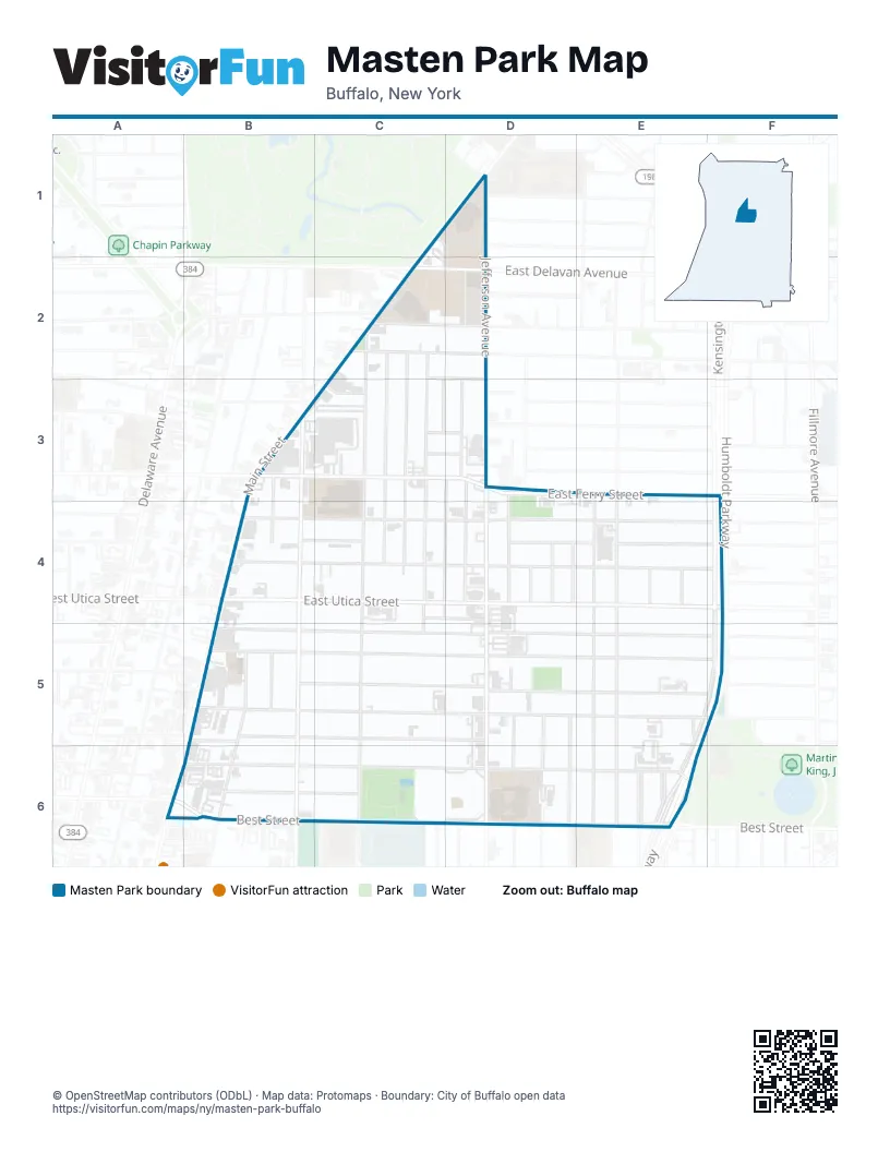
Street index of Masten Park
Each street on the sheet and the grid squares it crosses.
- Main StreetC1, D1, B4, A6
- Hedley PlaceD1
- Hughes AvenueD1
- Jefferson AvenueD1, D2, D3, D4, D5, D6
- Ada PlaceC2, C3
- Chester StreetC2, C4
- East Delavan AvenueC2, D2
- Florida StreetC2
- Lyth AvenueC2
- Northland AvenueC2
- Purdy StreetC2, C3, C4, C5
- Waverly StreetC2, C3, C4
- West Delavan AvenueC2
- Alexander PlaceD2, D3
- Spillman PlaceD2
- Otis PlaceB3, B4
- East Balcom StreetC3
- East Ferry StreetC3, D3, F3
- Elsie PlaceC3, D3
- Harlow PlaceC3, D3
- Morley PlaceC3
- Dupont StreetD3, D4
- Harwood PlaceD3
- Lonsdale RoadD3
- Verplanck StreetD3, C4, D4
- Welker StreetD3, D4
- Roehrer AvenueE3, E4, E5, E6
- Wohlers AvenueE3, E4, E5
- East Utica StreetB4, C4, D4, E4, F4
- Emerson PlaceB4, C4
- Glenwood AvenueB4, C4, D4, E4, F4
- Michigan AvenueB4, B5
- West Utica StreetB4
- Masten AvenueC4, C5, C6
- Memphis AlleyC4, D4
- Woodlawn AvenueC4, D4, F4
- Brooklyn StreetD4
- Hauf StreetD4
- Storz AvenueD4
- Winslow AvenueD4, E4, F4
- Celtic PlaceE4
- Portage StreetE4
- Humboldt ParkwayF4, E5, F5
- Coe PlaceB5
- Eaton StreetB5, C5, D5
- Ellicott StreetB5
- Holland PlaceB5
- Laurel StreetB5, C5, D5
- Northampton StreetB5, C5, D5, E5
- Southampton StreetB5, C5, D5
- Riley StreetC5, D5, F5
- Gerhardt StreetD5, D6
- Kingsley StreetD5, F5
- Landon StreetD5, E5, F5
- Pershing AvenueD5, D6
- Timon StreetD5, D6
- Willow PlaceD5
- Kensington ExpresswayE5, F5, E6
- West Parade AvenueE5, E6
- Best StreetA6, B6, C6, D6, E6
- Old Best StreetA6, B6
- Dodge StreetB6, C6, D6, E6
- Edna PlaceB6, C6
- Peach StreetC6
- Earl PlaceD6
- Grape StreetD6
- Johnson StreetE6
- Linden ParkE6
- Norway ParkE6
- Sherman StreetE6
Places on the map
- Around the Clock Express Mart
- Buffalo Academy for Visual and Performing Arts
- Compass House
- Demske Sports Complex
- Exodus Gardens Funeral Home
- Faithful Stones Church
- Frank E. Merriweather, Jr. Library
- Health Science Lot
- Health Sciences Charter School
- Johnnie B. Wiley Amateur Sports Pavilion
- Lincoln Memorial United Methodist Church
- Lower KAC Lot
- M&T Bank
- Main-Jefferson Lot
- Masten Park
- Metro Self-Storage Center
- Pelion Community Garden
- Perkins Park
- Rear Health Sciences Lot
- Saint Martin de Porres Catholic Church
- Science Hall Lot
- Spillman Lot
- Stanley Makowski Early Childhood Center
- Tops
- Upper KAC Lot
© OpenStreetMap contributors (ODbL) · Map data: Protomaps · Boundary: City of Buffalo open data