

New York map
New Rochelle map
A printable two-page map of New Rochelle (Westchester County, New York), drawn by VisitorFun from OpenStreetMap. Page two is the street index: every street on the sheet with its grid square, the same list as below.
Open the map (PDF, US Letter)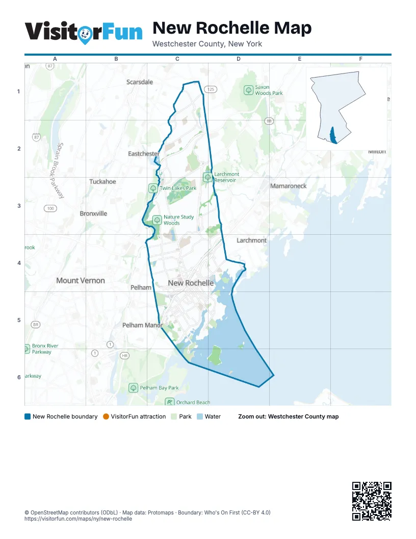
Street index of New Rochelle
Each street on the sheet and the grid squares it crosses.
- Baraud Road NorthC1
- Baraud Road SouthC1
- BoulevardC1
- Grand BoulevardC1
- Morris LaneC1
- Morris Lane SouthC1
- Palmer AvenueC1, C4, D4
- Plymouth DriveC1
- Puritan DriveC1
- Waverly RoadC1, C2
- Weaver StreetC1, D2
- Wilmot RoadC1, C2
- Fenimore RoadC2, C3
- Hutchinson BoulevardC2
- Hutchinson River ParkwayC2, C3, B4, C4
- Mill RoadC2
- New Wilmot RoadC2
- North AvenueC2, C3, C4, C5
- Pinebrook BoulevardC2, C3
- Quaker Ridge RoadC2, C3
- Stratton RoadC2
- Beechmont DriveC3, C4
- Forest AvenueC3, D3
- Lovell RoadC3
- Pinebrook RoadC3, C4
- Webster AvenueC3, C4, C5
- New Rochelle RoadB4
- Pelhamdale AvenueB4, C4
- 2nd StreetC4, C5
- 5th AvenueC4, D4
- Anderson StreetC4
- Brook StreetC4
- Burling LaneC4
- Cedar StreetC4
- Centre AvenueC4, C5
- Church StreetC4, C5, D5
- Clinton PlaceC4, C5
- Coligni AvenueC4
- Cross AvenueC4
- Cross Westchester AvenueC4
- Division StreetC4, C5
- East Main StreetC4, D4
- Eastchester RoadC4
- Echo AvenueC4, D4
- Elmer Miller CircleC4
- Franklin AvenueC4, C5, D5
- Garden StreetC4
- Grove AvenueC4, C5
- Harrison StreetC4
- Horton AvenueC4
- Huguenot StreetC4, D4, C5
- Joyce RoadC4
- Lawton StreetC4
- Le Count PlaceC4
- Lincoln AvenueC4
- Lockwood AvenueC4
- Locust AvenueC4, C5
- Main StreetC4, C5
- Mayflower AvenueC4
- Memorial HighwayC4
- New England ThruwayC4, D4, C5
- Norman Rockwell BoulevardC4
- Radisson PlazaC4
- River StreetC4
- Spring StreetC4
- Station Plaza NorthC4
- Stephenson BoulevardC4, D4
- Union AvenueC4
- Washington AvenueC4
- Willow AvenueC4
- Boston Post RoadD4
- Griffon StreetD4
- Pelham RoadD4, C5, D5
- Potter AvenueD4
- Pryer Manor RoadD4
- Stonelea PlaceD4
- Sunhaven DriveD4
- Allard AvenueC5
- Bayard StreetC5
- Beechwood AvenueC5
- Bonnefoy PlaceC5
- Davenport AvenueC5, D5
- Davis AvenueC5
- Drake AvenueC5
- Elm StreetC5
- Glen Island ApproachC5
- John StreetC5
- Jones StreetC5
- Kings HighwayC5
- Maple AvenueC5
- Meadow LaneC5
- Pintard AvenueC5
- Prospect StreetC5
- Shore RoadC5
- South Division StreetC5
- Trinity PlaceC5
- Union StreetC5
- Weyman AvenueC5, C6
- Woodland AvenueC5
- Hudson Park RoadD5
- Rodman OvalD5
- Glen Island ParkC6
Places on the map
- Aiello Park
- Albert Leonard Middle School
- Arrigoni Library and Technology Center
- Bayberry Association Park
- Beechmont Lake
- Beechwoods Cemetery
- Carpenter Pond
- Carpenter Pond Park
- Cooper Hill Apartments
- Costco
- Country Ridge Road
- D'Onofrio Park
- Davenport Park
- Davids Island
- Echo Island
- Five Islands Park
- Flowers Park
- Gill Library
- Glen Island
- Glenwood Lake
- Goodliffe Pond
- Heathcote Post Office
- Holy Sepulchre Cemetery
- Huckleberry Island
- Hudson Park
- Huguenot Lake
- Huguenot Park
- Iona Preparatory Lower School
- Iona Preparatory Upper School
- Iona University
- Isaac E. Young Middle School
- Lake Innisfree
- Larchmont Reservoir
- Masonic Care New Rochelle
- Montefiore New Rochelle
- Nature Study Woods
- New Roc Garage
- New Rochelle High School
- Pea Island
- Pelham Country Club
Next to New Rochelle
- Bronxville
- Eastchester
- Harrison
- Larchmont
- Mamaroneck
- Milton
- Mount Vernon map
- Pelham
- Pelham Manor
- Rye
- Scarsdale
- Tuckahoe
© OpenStreetMap contributors (ODbL) · Map data: Protomaps · Boundary: Who's On First (CC-BY 4.0)