

New York map
Hudson Valley map
The sheet's index lists 35 highways; I-87, I-84 and US 9 cross the most grid squares. Things to do inside the boundary: Bear Mountain State Park, Castle Fun Center and Cross County Shopping Center. Also on it: Beekman, Brewster and Cornwall.
Open the map (PDF, US Letter)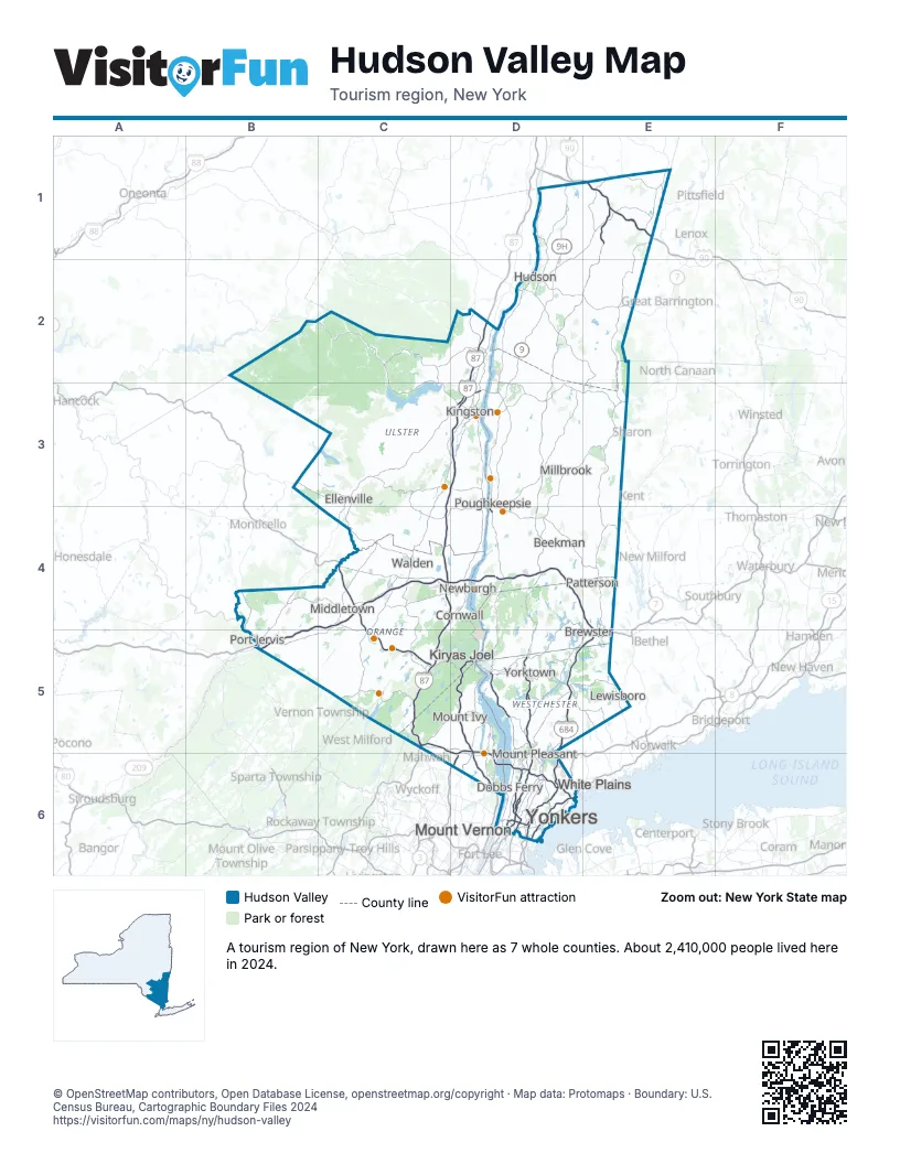
Highway index of Hudson Valley
Each highway on the sheet and the grid squares it crosses.
- I-84B4, B5, C4, D4, E4, E5
- I-87C3, C4, C5, D2, D3, D4, D5, D6
- I-90E1
- I-95D6
- I-287C5, D5, D6
- I-587D3
- I-684D5, D6, E5
- US 6B5, C5, D5
- US 9D1, D2, D3, D4, D5
- US 9WD3, D4, D5
- US 20E1
- US 44D3, D4, E3
- US 202D5
- US 209B4, B5, C3, C4, D3
- NY 9AD5
- NY 9GD2, D3
- NY 9HD1, D2
- NJ 17C5
- NY 17C4, C5
- NY 17MC5
- NY 22E1, E3, E4, E5
- NJ 23B5
- NY 23D2
- NY 28D3
- NY 32D3, D4
- NY 35D5
- NY 52B3, C3, D4
- NY 55C3, D3, D4, E4
- NY 82D3
- NY 100D5
- NY 118D5
- NY 199D3
- NY 218D5
- NY 303D5, D6
- NY 343E3
Things to do on the Hudson Valley map
- Bear Mountain State Park
- Castle Fun Center
- Cross County Shopping Center
- Dia Beacon
- Eleanor Roosevelt National Historic Site
- Empire City Casino
- Ferncliff Cemetery
- Frances Lehman Loeb Art Center
- Franklin D. Roosevelt Presidential Library and Museum
- Franny Reese State Park
- Hessel Museum of Art
- High Tor State Park
- Highland Lakes State Park
- Home of Franklin D. Roosevelt National Historic Site
- Hook Mountain State Park
- Hudson Highlands State Park Preserve
- Hudson River Cruises
- Hudson River Expeditions
- Hudson River Museum
- Hudson Valley Mall
- Hudson Valley Wine & Food Fest
- Innisfree Garden
- James Baird State Park
- Knox's Headquarters State Historic Site
- LEGOLAND New York Resort
- Margaret Lewis Norrie State Park
- Martin Van Buren National Historic Site
- Mount Peter
- Mt. Beacon Fire Observation Tower
- Neuberger Museum of Art
- Newburgh Mall
- Olana State Historic Site
- Old Rhinebeck Aerodrome
- Palisades Center
- Patriot's Park
- Philipse Manor Hall State Historic Site
- Playland
- Poughkeepsie Galleria
- Saint Paul's Church National Historic Site
- Shawangunk Wine Trail
- Sterling Forest State Park
- Stony Point Battlefield State Historic Site
- Storm King State Park
- Tibbetts Brook Park
- Untermyer Park and Gardens
- Vanderbilt Mansion National Historic Site
- Vassar Modfest
- Walkway Over the Hudson State Historic Park
- Ward Pound Ridge Reservation
- West Point Cemetery
- West Point Foundry Preserve
- Woodbury Common Premium Outlets
Places on the map
- Beekman
- Brewster
- Cornwall
- Dobbs Ferry
- Ellenville
- Hudson
- Kingston
- Kiryas Joel
- Lewisboro
- Middletown
- Millbrook
- Mount Ivy
- Mount Pleasant
- Mount Vernon
- Newburgh
- Patterson
- Port Jervis
- Poughkeepsie
- Walden
- White Plains
- Yonkers
- Yorktown
Next to Hudson Valley
- Western Connecticut
- Western Massachusetts
- Gateway Region
- Skylands Region
- Capital-Saratoga map
- New York City map
- The Catskills map
- Pocono Mountains
© OpenStreetMap contributors, Open Database License, openstreetmap.org/copyright · Map data: Protomaps · Boundary: U.S. Census Bureau, Cartographic Boundary Files 2024