

New York road map
New York highway map
28 Interstate routes run about 1,736 miles in New York, each on a sheet of its own. The sheet's index lists 71 highways; I-90, NY 17 and I-87 cross the most grid squares. Towns on it: New York City, Brookhaven and Buffalo.
Open the map (PDF, US Letter)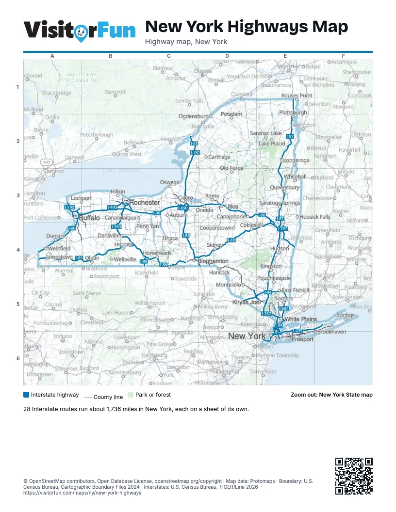
Road maps of New York
24 road maps: each Interstate and byway on a sheet of its own.
- I-81 in New York
- I-84 in New York
- I-86 in New York
- I-87 in New York
- I-88 in New York
- I-90 in New York
- I-95 in New York
- I-190 in New York
- I-278 in New York
- I-287 in New York
- I-290 in New York
- I-390 in New York
- I-481 in New York
- I-490 in New York
- I-495 in New York
- I-678 in New York
- I-684 in New York
- I-690 in New York
- I-787 in New York
- I-890 in New York
- Great Lakes Seaway Trail
- Lakes to Locks Passage
- Mohawk Towpath Byway
- Palisades Scenic Byway
Highway index of New York
Each highway on the sheet and the grid squares it crosses.
- I-78E6
- I-81C2, C3, C4, D4
- I-84D5, E5
- I-86A4, B4, C4, D4
- I-87E1, E2, E3, E4, E5
- I-88C4, D4, E4
- I-90A3, A4, B3, C3, D3, E3, E4
- I-95E5
- I-99C4
- I-190A3
- I-278E5, E6
- I-287E5
- I-290A3
- I-295E5, E6
- I-390B3, B4
- I-490B3
- I-495E5, E6, F5
- I-590B3
- I-678E5, E6
- I-684E5
- I-690C3
- I-695E5
- I-781C2
- I-787E4
- I-790D3
- I-890E3, E4
- I-990A3
- US 1E5
- US 6E5
- US 9E5
- US 15C4
- US 202E5
- US 209E4
- US 219A3, A4, B4
- NY 5A3, C3, D3
- NY 7C4, D4, E4
- NY 8D3
- NY 9AE5, E6
- NY 12D3
- NY 13C4
- NY 16B4
- NJ 17E5
- NY 17A4, B4, C4, D4, D5, E5
- NY 17ME5
- NY 22E5
- NY 27E6, F5, F6
- NY 28D4
- NY 31C3
- NY 33A3
- NY 34C4
- NY 49D3
- NY 52E5
- NY 85E4
- NY 104B3
- NY 135E5, E6
- NY 199E4
- NY 204B3
- NY 324A3
- NY 390B3
- NY 400A3, B3, B4
- NY 440E6
- NY 481C3
- NJ 495E6
- NY 495E6
- NY 531B3
- NY 590B3
- NY 690C3
- NY 695C3
- NY 787E4
- NY 878E6
- NY 890E3
Places on the map
- Auburn
- Binghamton
- Brookhaven
- Buffalo
- Canajoharie
- Canandaigua
- Carthage
- Cicero
- Cobleskill
- Cooperstown
- Dansville
- Dunkirk
- East Fishkill
- Freeport
- Hancock
- Hilton
- Hoosick Falls
- Hornell
- Horseheads
- Hudson
- Ithaca
- Jamestown
- Kingston
- Kiryas Joel
- Lake Placid
- Lockport
- Monticello
- New York
- Ogdensburg
- Old Forge
- Olean
- Oneida
- Oswego
- Penn Yan
- Plattsburgh
- Potsdam
- Poughkeepsie
- Queensbury
- Rochester
- Rome
- Rouses Point
- Saranac Lake
- Saratoga Springs
- Sidney
- Somers
- Springs
- Ticonderoga
- Utica
- Wellsville
- Westfield
- White Plains
- Whitehall
© OpenStreetMap contributors, Open Database License, openstreetmap.org/copyright · Map data: Protomaps · Boundary: U.S. Census Bureau, Cartographic Boundary Files 2024 · Interstates: U.S. Census Bureau, TIGER/Line 2026