

New York map
Newburgh map
About 28,181 people live here (Census Bureau, 2024 estimate). The sheet's index lists 212 streets; South Street, Gidney Avenue and Broadway cross the most grid squares. Also on it: Associated Reformed Church, AutoZone and Best Temple Church of God in Christ.
Open the map (PDF, US Letter)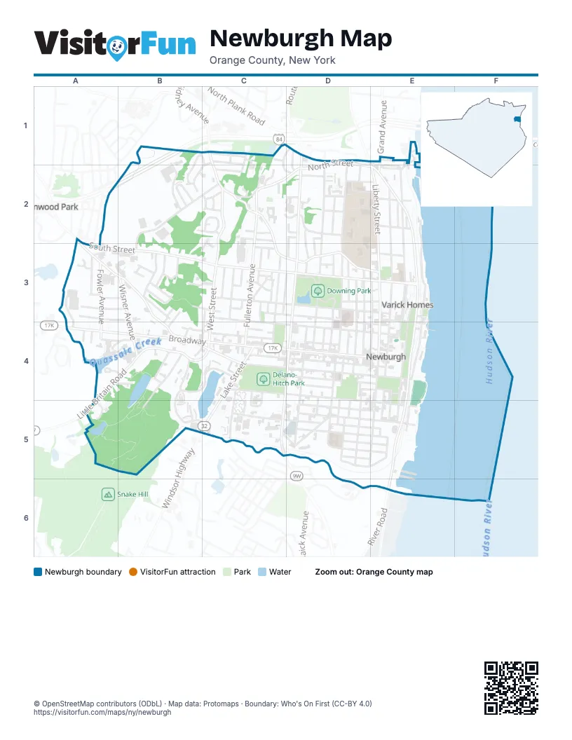
Street index of Newburgh
Each street on the sheet and the grid squares it crosses.
- Morningside RoadB1, C1
- Scobie DriveB1, B2
- Sherman DriveB1, B2
- Barton StreetC1
- Blake StreetC1
- Brady AvenueC1, C2
- Crescent AvenueC1, D1, C2, D2
- Flemming DriveC1, B2, C2
- Gidney AvenueC1, C2, C3, D3, E3
- Plaine TerraceC1
- Sunrise LaneC1, C2
- West StreetC1, C2, C3, C4
- Balmville RoadD1, E2
- Central AvenueD1, D2
- Jamison PlaceD1, D2
- North Plank RoadD1
- North Robinson AvenueD1, D2, D3, D4
- North StreetD1, C2, D2, E2
- Powell AvenueD1, D2, D3
- Stern DriveD1
- Barclay StreetE1
- Grand AvenueE1, E2
- North Montgomery StreetE1, E2
- Park PlaceE1, E2
- Rogers AvenueE1
- Rogers PlaceE1
- Dupont AvenueA2, A3, B3, B4
- Old Pierces RoadA2, A3
- South Plank RoadA2
- South StreetA2, A3, B3, C3, D3, E3
- Circle DriveB2, C2
- Odell StreetB2, C2
- Pierces RoadB2, C2, B3
- Pleasant PlaceB2
- Williamsburg DriveB2
- Deforest AvenueC2
- Fullerton AvenueC2, C3, C4
- Gardner StreetC2
- Gedney WayC2
- Hampton PlaceC2
- Kingsley PlaceC2
- Leicht PlaceC2
- McCord DriveC2
- Memorial DriveC2
- Pleasant Valley WayC2
- Roe StreetC2
- Warden CircleC2
- Carobene CourtD2, E2
- Carpenter AvenueD2, D3, D4
- Castle AvenueD2
- City Terrace NorthD2
- Cottage AvenueD2
- Elmwood PlaceD2, E2
- Hudson View TerraceD2, D3
- Mandigo PlaceD2, D3
- Marne AvenueD2
- Pine StreetD2
- Rural LaneD2
- Russell RoadD2, D3
- Sequestered RoadD2
- Vista PlaceD2
- Willett AvenueD2
- Baucks PlaceE2
- Broad StreetE2
- Forsyth PlaceE2
- Front StreetE2, E3, E4
- Grand StreetE2, E3, E4
- Leroy PlaceE2
- Liberty StreetE2, E3, E4, E5
- Montgomery StreetE2, E3, E4
- Nicoll StreetE2
- Reverend Martin Luther King StreetE2, E3, E4
- Belknap StreetA3
- Favoriti AvenueA3
- Fowler AvenueA3, A4
- Maple StreetA3, B3
- Oak StreetA3, B3
- Pierces Road SouthA3
- Poplar StreetA3, B3
- Taft AvenueA3
- Thompson StreetA3
- Vanamee StreetA3
- White StreetA3
- Anderson StreetB3, B4
- Hawthorne AvenueB3
- Kennedy PlaceB3
- Larter AvenueB3
- Monroe StreetB3
- Morris AvenueB3
- Orchard StreetB3, C3
- Palantine AvenueB3
- Shipp StreetB3
- Van Cleft AvenueB3
- Wilkin StreetB3, B4
- Wisner AvenueB3, B4
- Allison AvenueC3
- Bennett StreetC3
- Bush AvenueC3
- Carter StreetC3, D3
- Columbus AvenueC3
- Columbus LaneC3
- Englebride PlaceC3
- Farrell StreetC3
- First StreetC3, C4, D4, E4
- Grove StreetC3, C4
- Hillcrest PlaceC3
- Hughes StreetC3
- Humphries PlaceC3
- Lilly StreetC3
- Lincoln TerraceC3
- McKinstry StreetC3
- Norton StreetC3
- Prospect StreetC3, C4
- Richman AvenueC3
- Roosevelt PlaceC3
- Third StreetC3, D3, E3
- Townsend AvenueC3, D3
- Underhill PlaceC3, C4
- Valley AvenueC3
- Wilson StreetC3
- Cedar StreetD3
- City TerraceD3, D4
- Dubois StreetD3, D4
- Elm StreetD3
- Farrington StreetD3, E3
- Haible WayD3
- Johnston StreetD3, D4
- Lander StreetD3, D4
- Mayor Joann Shapiro DriveD3
- North Miller StreetD3
- Park AvenueD3
- 2nd StreetE3, E4
- 3rd StreetE3
- 4th StreetE3
- Catherine StreetE3
- Chambers StreetE3, E4
- Clinton StreetE3
- Smith StreetE3
- Varick HomesE3
- Сolden StreetE3, E4
- BroadwayA4, B4, C4, D4, E4
- Carroll StreetA4, B4
- Chestnut StreetA4
- Little Britain RoadA4, B4, C4, A5
- Locust StreetA4, B4
- McDowell PlaceA4
- Nott PlaceA4
- Beach StreetB4
- Cerone PlaceB4
- Ellis AvenueB4, B5
- Hillside CourtB4
- Lake DriveB4, C4, B5, C5
- Old Little Britain RoadB4, C4
- Temple AvenueB4
- Washington TerraceB4, C4
- West High StreetB4
- West Van Ness StreetB4, C4
- Ann StreetC4, D4, E4
- Galloway AvenueC4
- Lake StreetC4, C5
- Lakeside PlazaC4
- South Robinson AvenueC4, D4, C5
- South William StreetC4, D4, E5
- Van Ness StreetC4, D4
- Walsh AvenueC4, C5
- Washington StreetC4, D4, E4
- Amity StreetD4
- Avoca StreetD4, D5
- Campbell StreetD4, E4
- Clark StreetD4
- Concord StreetD4
- East Parmenter StreetD4, E4
- Federal StreetD4
- Hasbrouck StreetD4
- Little Monument StreetD4, D5
- Lutheran StreetD4
- Mill StreetD4, D5
- South Clark StreetD4, D5
- South Johnston StreetD4
- South Lander StreetD4, D5
- South Miller StreetD4
- Spring StreetD4, E4
- West Parmenter StreetD4
- William StreetD4, D5
- 1st StreetE4
- Carpenter StreetE4
- Colden StreetE4, E5
- Edward StreetE4, E5
- Johnes StreetE4, E5
- Lafayette StreetE4
- South Water StreetE4, E5, E6
- Washington PlaceE4
- Corwin CourtA5
- Commercial PlaceC5
- Deyo PlaceC5, D5
- Dickson StreetC5, D5
- Kinney CourtC5
- Quassaick AvenueC5
- Bay View TerraceD5, E5
- Bayview TerraceD5
- Beacon StreetD5, E5
- Benkard AvenueD5, E5
- Bridge StreetD5
- Carson AvenueD5, E5
- Courtney AvenueD5, E5
- Henry AvenueD5, E5
- Liberty Street Washington HeightsD5, E5
- Monument StreetD5
- Overlook PlaceD5, E5
- Renwick StreetD5, E5
- River StreetE5
- Riverview PlaceE5
Places on the map
- Associated Reformed Church
- AutoZone
- Best Temple Church of God in Christ
- Billy Joe‘s Ribworks
- Broadway & Liberty
- Broadway Grammar School
- Calvary Presbyterian Church
- Chestnut Street School
- Christ Lutheran Church
- Church of Our Father
- Church of the Good Shepherd
- Church of the Nazarene
- Circle Drive
- Citgo
- City of Newburgh
- City of Newburgh Police
- Clinton Square
- Colden Plaza
- Congregation Agudas Achim
- Congregation Agudas Israel
- Crystal Lake
- Delano Hitch Stadium
- Delano-Hitch Park
- Downing Park
- Downing Pond
- Dunkin'
- Dutch Reformed Church
- Ebenezer Baptist Church
- Faith Gospel Tabernacle
- First Baptist Church
- First Church of Christ Scientist
- First Congregational Church
- First United Methodist Church
- First United Presbyterian Church
- Gidney Avenue Memorial School
- Grace Methodist Church
- Grand & Third
- Grand Street Public School
- Harrison Pond
Next to Newburgh
- Glenwood Park
© OpenStreetMap contributors (ODbL) · Map data: Protomaps · Boundary: Who's On First (CC-BY 4.0)