

New York map
Old First Ward map
A printable two-page map of Old First Ward (Buffalo, New York), drawn by VisitorFun from OpenStreetMap. Page two is the street index: every street on the sheet with its grid square, the same list as below.
Open the map (PDF, US Letter)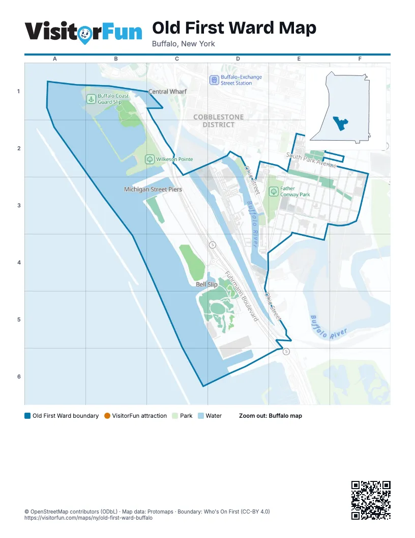
Street index of Old First Ward
Each street on the sheet and the grid squares it crosses.
- Fuhrmann BoulevardB1, C2, C3, C4, D4, D5, E5
- Buffalo SkywayC2, C3, D4, D5, E5
- South Michigan AvenueC2, D2, C3
- 175 Ohio St DrivewayD2
- Ganson StreetD2, D3, D4
- Mackinaw StreetD2, E2, E3, F3
- Ohio StreetD2, D3, D4, E5
- South Michigan Avenue Lift BridgeD2
- Alabama StreetE2, E3, E4
- Coatsworth AlleyE2
- Fulton StreetE2, F2
- Hayward StreetE2
- Louisiana StreetE2, D4, E4
- Miami StreetE2, E3, F3
- Perry StreetE2
- South Park AvenueE2, F2
- Stannard AlleyE2
- Hamburg StreetF2, E3, F3
- Katherine StreetF2, F3
- Red Jacket StreetF2
- Sidway StreetF2, F3
- Outer Harbor DriveC3, C4, D4
- Chicago StreetD3
- South StreetD3, E3
- Kentucky StreetE3
- O'Connell AvenueE3, F3
- Republic StreetE3
- St Clair StreetE3, D4, E4
- Tennessee StreetE3
- Vandalia StreetE3
- Vincennes StreetE3
Places on the map
- Agway Elevator
- Barcalo Living & Commerce
- Buffalo Coast Guard Slip
- Buffalo RiverFest Park
- Buffalo RiverWorks
- Buffalo RiverWorks Parking Lot
- Buffalo Scholastic Rowing Association
- Buoy Yard
- Captain of the Port
- Cazenovia Community Boating Center
- CGX
- City Ship Canal
- Connecting Terminal Elevator
- Father Conway Park
- Fuhrmann Boulevard
- LaFarge
- Lighthouse Point Park
- Our Lady of Perpetual Help Catholic Church
- Pump Track
- Resurgence Brewing Company
- St Marys Cement / Spencer Kellogg Elevator
- Tewksbury Lodge
- Times Beach Nature Preserve
- Track 1
- Track 2+
- U.S. Coast Guard - Sector Buffalo
- Wilkeson Pointe
Next to Old First Ward
- Canalside
- Central Wharf
- Cobblestone District
- Visiting Ship's Dock
© OpenStreetMap contributors (ODbL) · Map data: Protomaps · Boundary: Who's On First (CC-BY 4.0)