

New York map
Palm Tree map
About 43,863 people live here (Census Bureau, 2024 estimate). The sheet's index lists 89 streets; Forest Road, Acres Road and Bakertown Road cross the most grid squares. Also on it: Village of Kiryas Joel, Coronet Lake and Forest Road Lake.
Open the map (PDF, US Letter)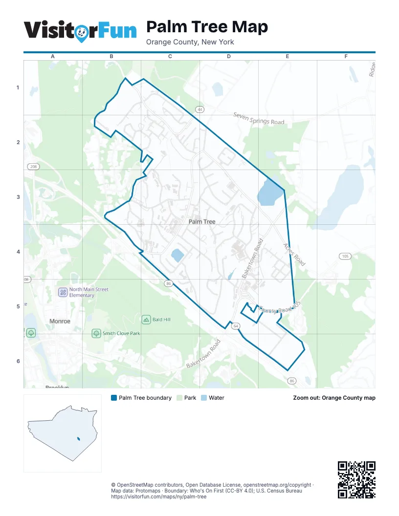
Maps inside Palm Tree
1 map inside, from the street map of Palm Tree down.
Street index of Palm Tree
Each street on the sheet and the grid squares it crosses.
- Karlsburg RoadB1, C1, B2
- Seven Springs Mountain RoadB1, C1, C2
- Seven Springs RoadB1, B2
- Chevron RoadC1, C2
- Nicklesburg RoadC1, C2
- Radomsk WayC1
- Rovna CourtC1, C2
- Anipoli DriveB2
- G RoadB2
- Premishlan WayB2
- Ruzhin RoadB2, C2
- Berdichev RoadC2, C3
- Chernobyl CourtC2
- Forest RoadC2, D2, C3, B4, C4
- Karlin BoulevardC2
- Krakow BoulevardC2
- Mezabish PlaceC2
- Mountain RoadC2
- Paksh PlaceC2
- Raywood DriveC2
- Sasev CourtC2
- Satmar DriveC2, D2, D3
- Taitch CourtC2
- Tzfas RoadC2
- Volova RoadC2
- Acres RoadD2, D3, E3, E4
- Koritz CourtD2
- Krolla DriveD2
- Lemberg CourtD2, D3
- Vitebsk RoadD2
- D A Weider BoulevardB3, B4, C4
- Kosnitz RoadB3, C3
- Schunnemunk RoadB3, C3, B4
- Carter LaneC3, C4
- Garfield RoadC3, C4
- Gorlitz CourtC3
- Hayes CourtC3, D3
- Iron Hill PlazaC3
- Lipa Friedman LaneC3
- Liska WayC3
- Lizensk BoulevardC3
- Mordche Scher BoulevardC3
- Sanz CourtC3
- Zenta RoadC3, C4
- Fillmore CourtD3, D4
- Getzil Berger BoulevardD3, D4
- Israel Zupnick DriveD3, D4
- Kerestier CourtD3, D4
- Orshava CourtD3
- Siget CourtD3
- Taylor CourtD3
- Bakertown RoadE3, D4, E4, D5
- Apta WayC4
- Buchanan CourtC4
- Eahal CourtC4, D4
- Lublin WayC4
- Preshburg BoulevardC4
- Quickway RoadC4
- Rimenev CourtC4, C5
- Shinev CourtC4, D4
- Strelisk CourtC4
- Van Buren DriveC4, D4
- Daj BoulevardD4, C5, D5
- Dinev RoadD4, E4
- Drubige WayD4
- Hamaspik WayD4, E4
- Kahan DriveD4
- Kalev WayD4
- Leipnik WayD4, D5
- Meron DriveD4, D5
- Prag BoulevardD4, D5
- Ratzfert WayD4, D5
- Vayoel Moshe CourtD4
- Amsterdam WayE4
- Brigel WayE4
- Dinev CourtE4
- Frankfurt RoadE4
- Hamburg WayE4, E5
- Komarna WayE4
- MInkach WayE4
- Tarnigrad WayE4
- Toltchav WayE4
- Stropkov CourtC5
- County Road 105D5, E5
- Future Industrial RoadD5, E5
- Nininger RoadD5, D6, E6
- Teverya WayD5
- Yoel Klein BoulevardD5
- Old Country RoadE5
Places on the map
- bies rochel Paradise
- Binos Desha School
- Butter Blend
- Cong Yetev Lev - Veyoel Moshe
- Coronet Lake
- Ezras Choilim Health Center
- Forest Road Lake
- Grand Food Supermarket
- HealthMart
- Kiryas Joel Pharmacy
- KJ Auto repair
- Laundau's Supermarket
- North East Community Bank
- Refresh Supermarket
- Rimenev Court
- Satmar Cemetery
- United Talmudical Academy
- Village of Kiryas Joel
- Yetev Lev Satmar
Next to Palm Tree
- Monroe
© OpenStreetMap contributors, Open Database License, openstreetmap.org/copyright · Map data: Protomaps · Boundary: Who's On First (CC-BY 4.0); U.S. Census Bureau















