

New York map
Poughkeepsie map
About 32,293 people live here (Census Bureau, 2024 estimate). The sheet's index lists 323 streets; Main Street, North Clinton Street and Church Street cross the most grid squares. Also on it: 7-Eleven, Adriance Memorial Library and Alex Food and Grocery II.
Open the map (PDF, US Letter)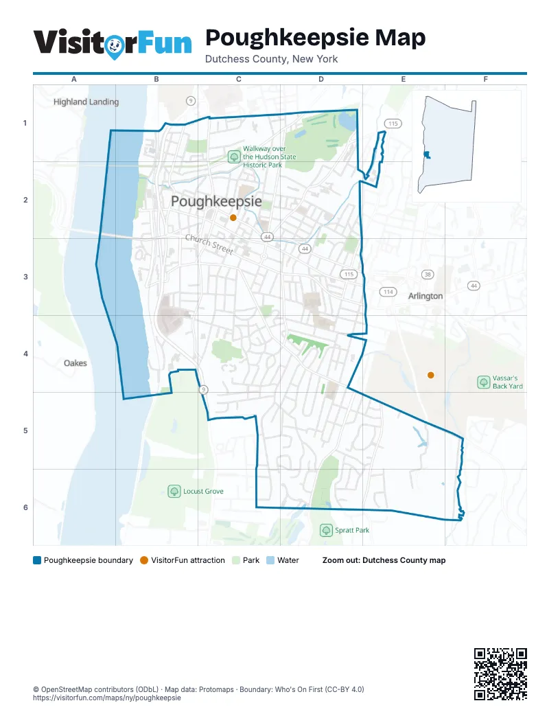
Street index of Poughkeepsie
Each street on the sheet and the grid squares it crosses.
- Albany StreetB1, B2
- Bain AvenueB1, C1, B2
- Delafield StreetB1, B2
- Dutchess AvenueB1, B2
- Hoffman StreetB1
- Kittredge PlaceB1
- North Water StreetB1, B2
- Spruce StreetB1
- Talmadge StreetB1, B2
- Vernon TerraceB1, C1
- Whinfield StreetB1
- Beekman StreetC1
- Clark StreetC1
- Fairview AvenueC1
- Garden StreetC1, C2
- Green StreetC1
- Henderson StreetC1
- Kelsey RoadC1
- Morton StreetC1, D1
- North Hamilton StreetC1, C2, C3
- North RoadC1
- Orchard PlaceC1
- Parker AvenueC1, D1, C2
- Poplar StreetC1
- Taylor AvenueC1
- Washington StreetC1, C2
- Buckingham AvenueD1
- Creek RoadD1
- Foster StreetD1
- Little George Street LoopD1
- North Clinton StreetD1, C2, D2, C3
- Oakdale AvenueD1
- Reservoir RoadD1
- Salt Point TurnpikeD1, E1
- Smith StreetD1, C2, D2
- Sunnyside AvenueD1
- Violet AvenueD1
- Bellevue AvenueB2
- Charles StreetB2
- Church StreetB2, B3, C3, D3
- Columbus DriveB2, C2, C3
- Davies CourtB2
- Davies PlaceB2
- Davis StreetB2
- Delano StreetB2
- Detective John Falcone Memorial AvenueB2
- Dongan PlaceB2
- Duane StreetB2
- Gerald DriveB2, B3
- Gifford AvenueB2, C2
- Grand StreetB2, C2
- Jefferson StreetB2, B3
- John M. Flowers CircleB2
- Little Jefferson StreetB2
- Long StreetB2
- Main StreetB2, C2, C3, D3, E3
- Mansion StreetB2, C2, D2
- Mill StreetB2, C2
- Mount Carmel PlaceB2
- North Bridge StreetB2, C2
- North Clover StreetB2
- North Perry StreetB2
- Rinaldi BoulevardB2, B3
- South Bridge StreetB2
- South Clover StreetB2
- South Perry StreetB2
- Union StreetB2, C2
- Vassar StreetB2, C2
- Verrazano BoulevardB2, C2
- Academy StreetC2, C3, C4
- Balding AvenueC2
- Brookside AvenueC2
- Cannon StreetC2, C3, D3
- Catharine StreetC2
- Civic Center PlazaC2
- Conklin StreetC2
- Cottage StreetC2, D2
- Crannell StreetC2
- Croydon CourtC2
- East-West ArterialC2, D3
- Elm PlaceC2
- Fallkill PlaceC2
- Harrison StreetC2, D2, D3
- High StreetC2
- Hurlihe StreetC2, B3, C3
- Lafayette PlaceC2
- Little Smith StreetC2, C3
- Market StreetC2, C3
- Marshall StreetC2
- Oakley StreetC2, D2
- Park PlaceC2, D2
- Thompson StreetC2, D2
- West Oakley StreetC2
- Winnikee AvenueC2, D2, D3
- Zimmer AvenueC2
- Allen PlaceD2
- Arnold RoadD2
- Bartlett StreetD2
- Bement AvenueD2, D3
- Corlies AvenueD2, D3
- Du Bois AvenueD2
- Dutcher PlaceD2
- East Arnold RoadD2
- Ellsworth LaneD2
- Emmot PlaceD2
- Fallkill AvenueD2
- Fitchett StreetD2
- Grant StreetD2
- Howard StreetD2, E2
- Hudson AvenueD2
- Hudson Avenue ExtensionD2
- Innis AvenueD2, D3
- Lawrence RoadD2
- Lent StreetD2
- Milton StreetD2
- Morgan AvenueD2
- Pershing AvenueD2, D3
- Van Kleeck DriveD2
- Weed StreetD2
- West Arnold RoadD2
- Center StreetB3
- Columbia StreetB3
- Dean PlaceB3, C3
- Eastman TerraceB3, C3
- Franklin StreetB3, C3
- Gate StreetB3
- Grove StreetB3
- Hendryk DriveB3
- Hudson Heights DriveB3
- Hudson Pointe DriveB3, B4
- Laney PlaceB3
- Laurel StreetB3
- Lincoln AvenueB3, B4
- Little Market StreetB3, C3
- Mid-Hudson BridgeB3
- Montgomery StreetB3, C3
- Morgan CourtB3
- Nina CourtB3
- Pine StreetB3, C3
- Pine Street SpurB3
- Reade PlaceB3
- Stout CourtB3
- Suncrest CourtB3, C3
- Tubman TerraceB3
- Young StreetB3
- Barclay StreetC3
- Carroll StreetC3
- Circular RoadC3, C4
- Crescent RoadC3, C4
- Dwight StreetC3
- Fairmont StreetC3
- Forbus StreetC3, D3, D4
- Garfield PlaceC3
- Hammersley AvenueC3
- Hanscom AvenueC3
- Holmes StreetC3
- Hooker AvenueC3, C4, D4, E5
- Noxon StreetC3
- Reservoir SquareC3
- South AvenueC3, B4, C4
- South Clinton StreetC3
- South Hamilton StreetC3, C4
- State StreetC3
- Virginia AvenueC3
- Baker StreetD3
- Boulevard KnollsD3
- Daniels CourtD3, D4
- Edgar StreetD3
- Flannery AvenueD3
- Fountain PlaceD3, D4
- Fox TerraceD3
- Gray StreetD3
- Grubb StreetD3, E3
- Hoffman AvenueD3
- Jewett AvenueD3
- King StreetD3
- Lexington AvenueD3
- Lown CourtD3, D4
- Mack RoadD3
- Manitou AvenueD3
- Maple StreetD3
- May StreetD3
- Muldowney CircleD3
- North Cherry StreetD3
- North White StreetD3
- Palmer AvenueD3
- Quaker LaneD3
- Radcliffe RoadD3
- Reynolds AvenueD3
- Roosevelt AvenueD3
- Rose StreetD3
- South Cherry StreetD3, D4
- South Grand AvenueD3, D4, D5
- South White StreetD3
- West Haight AvenueD3
- Worrall AvenueD3, D4
- Streit AvenueE3
- Fox StreetB4
- Linwood AvenueB4
- Livingston StreetB4, C4
- Oak StreetB4
- Phoenix StreetB4
- Prospect StreetB4
- South RoadB4, C5
- Sunfish Cove RoadB4
- Adriance AvenueC4
- Barnard AvenueC4
- De Garmo PlaceC4, D4
- Eden TerraceC4
- Ferris LaneC4, D4, C5, D5
- Gaskin RoadC4
- Gus Siko RoadC4, C5
- Ivy TerraceC4
- Kimball RoadC4, C5
- Loockerman AvenueC4
- Marian AvenueC4, D4
- Osborne RoadC4
- Platt StreetC4
- Rosalind RoadC4
- Seaman RoadC4, C5
- St Annes RoadC4, D4
- St Johns ParkwayC4, C5
- West College AvenueC4, D4
- West Winding RoadC4
- Whitehouse AvenueC4
- Wilbur CourtC4
- Wilbur TerraceC4
- Willow BendC4
- Yates BoulevardC4
- Beechwood TerraceD4
- College AvenueD4
- Douglas StreetD4
- Estelle RoadD4
- Fountainbrook AvenueD4
- Fulton AvenueD4
- Glenwood AvenueD4
- Grand AvenueD4
- Maryland AvenueD4
- Meyer AvenueD4
- Mildred AvenueD4
- Mitchell AvenueD4, D5
- North Randolph AvenueD4
- Oak Crescent StreetD4
- Oakwood BoulevardD4, D5
- Park AvenueD4, E4
- Parkwood BoulevardD4, D5
- South Randolph AvenueD4, C5, D5
- Underhill AvenueD4
- Whittier BoulevardD4, D5
- Willow AvenueD4
- Wilson BoulevardD4
- Woodbine AvenueD4
- Woodland AvenueD4, D5
- Alden RoadC5, D5
- Bancroft RoadC5
- Beechwood AvenueC5, C6
- Bobrick RoadC5
- Cedarcliff LaneC5
- Lilling RoadC5, D5, D6
- Sharon DriveC5
- St Josephs TerraceC5
- Tamidan RoadC5, D5, C6, D6
- Arnold BoulevardD5, E5
- Bellmore DriveD5, D6
- Clubhouse CourtD5, E5
- Crystal Hill LaneD5
- Deer PathD5, E5
- Elmwood AvenueD5
- Fox HillD5
- Fox RunD5, E5
- Kingston AvenueD5, E5
- Linden RoadD5
- Merrick RoadD5, D6
- Miller RoadD5, E5
- Monell AvenueD5, D6
- Mulberry CourtD5
- Panorama BoulevardD5, E5
- Philmore DriveD5, D6
- Pine Cone CourtD5
- Ruppert RoadD5
- Thornwood DriveD5, D6
- Wantaugh AvenueD5, D6
- Wilbur BoulevardD5, D6
- Wilmot TerraceD5
- Austin CourtE5
- Brewers LaneE5
- Cedar AvenueE5, E6
- Downing PlaceE5
- Falcon CourtE5
- Greenhouse LaneE5
- Hewlett RoadE5, D6, E6
- KnightsbridgeE5
- Lorie LaneE5
- New Hackensack RoadE5, F5
- Red Cardinal CourtE5
- Rombout House LaneE5
- Scenic LaneE5
- Spoor AvenueE5
- Squires GateE5
- Swan CourtE5
- Swan LaneE5
- Thorndale AvenueE5
- Vassar Farm LaneE5, E6
- Zach's WayF5, F6
- Justamere LaneC6
- Murfield CourtC6, D6
- Santa Anna DriveC6
- Burkdale CourtD6
- Glen Eagles DriveD6
- High Ridge RoadD6
- Keith PlaceD6
- Lynbrook RoadD6
- Muirfield CourtD6
- Prestwick CourtD6
- Spratt AvenueD6
- Traffic CircleD6
- Tumberry CourtD6
- Turnberry CourtD6
- Walnut Hill RoadD6
- Pembroke CourtE6
- Pembroke DriveE6
- Richmond RoadE6
- Whitehall RoadE6
Places on the map
- 7-Eleven
- Adriance Memorial Library
- Alex Food and Grocery II
- Applewood Circle
- AutoZone
- Balsam Square
- Barrett Art Center
- Bartlett Park
- Beulah Baptist Church
- Blue Collar Brewery
- Camaria Deli
- Casa Latina
- City of Poughkeepsie
- College Hill Golf Course
- College Hill Park
- Cunneen-Hackett Cultural Center
- Dongan Place
- Dutchess Auto Collision
- Dutchess County Office for the Aging
- Dutchess County Sheriff
- Earline Patrice Park
- Eastman Park
- Ebenezer Baptist Church
- Faith Assembly of God Church
- Fall Kill Clay Works
- Family Dollar
- First Church of Christ Scientist
- First Congregational United Church of Christ
- First Presbyterian Church
- Forest Restoration Planting
- G. W. Krieger Elementary School
- Glebe House
- Gulf
- Holy Comforter Episcopal Church
- Hudson Pointe
- John M. Flowers Circle
- Kaal Rock Park
- Kimisis Greek Orthodox Church
- King Street Park
- King's Court Brewing Company
Next to Poughkeepsie
- Arlington
- Highland Landing
- Oakes
© OpenStreetMap contributors (ODbL) · Map data: Protomaps · Boundary: Who's On First (CC-BY 4.0)