

New York map
Queens County map
About 2,316,841 people live here (Census Bureau, 2024 estimate). The sheet's index lists 187 streets; Grand Central Parkway, Cross Island Parkway and Francis Lewis Boulevard cross the most grid squares. Things to do inside the boundary: Citi Field.
Open the map (PDF, US Letter)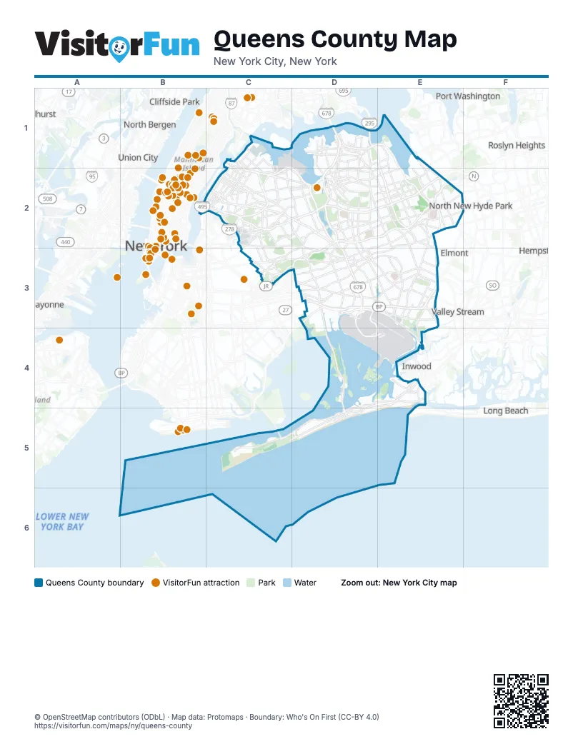
Street index of Queens County
Each street on the sheet and the grid squares it crosses.
- 21st StreetC1, C2
- 8th StreetC1
- 94th StreetC1, C2
- Astoria BoulevardC1, C2, D2
- Grand Central ParkwayC1, C2, D2, E2
- Hoyt Avenue NorthC1, C2
- Hoyt Avenue SouthC1, C2
- Robert F. Kennedy BridgeC1
- Vernon BoulevardC1, C2
- 14th AvenueD1
- Bronx-Whitestone BridgeD1
- Clearview ExpresswayD1, E1, E2
- Clintonville StreetD1
- College Point BoulevardD1, D2
- Cross Island ParkwayD1, E1, E2, E3
- Cross Island Parkway Service RoadD1
- Francis Lewis BoulevardD1, D2, E2, E3
- Linden PlaceD1, D2
- Throgs Neck BridgeD1
- Utopia ParkwayD1, D2
- Whitestone ExpresswayD1, D2
- Whitestone Expressway Service RoadD1, D2
- 235th StreetE1, E2
- Queens-Midtown TunnelB2, C2
- 11th StreetC2
- 29th StreetC2
- 31st StreetC2
- 33rd StreetC2
- 36th AvenueC2
- 37th AvenueC2
- 39th StreetC2
- 41st AvenueC2
- 43rd AvenueC2
- 47th StreetC2
- 48th StreetC2
- 49th StreetC2
- 51st AvenueC2
- 54th StreetC2
- 55th AvenueC2
- 55th StreetC2
- 56th RoadC2
- 57th PlaceC2
- 58th RoadC2
- 58th StreetC2
- 64th StreetC2
- 68th StreetC2
- 69th StreetC2
- Astoria Boulevard NorthC2
- Astoria Boulevard SouthC2
- Boody StreetC2
- Borden AvenueC2
- BroadwayC2, E4
- Brooklyn-Queens ExpresswayC2
- Brooklyn-Queens Expressway EastC2
- Brooklyn-Queens Expressway WestC2
- Crescent StreetC2
- Ed Koch Queensboro Bridge Lower LevelC2
- Ed Koch Queensboro Bridge Lower RoadwayC2
- Ed Koch Queensboro Bridge Upper LevelC2
- Flushing AvenueC2, C3
- Fresh Pond RoadC2, C3
- Grand AvenueC2
- Grand StreetC2
- Greenpoint AvenueC2
- Jackson AvenueC2
- Junction BoulevardC2, D2
- Laurel Hill BoulevardC2
- Long Island ExpresswayC2, D2, E2
- Maspeth AvenueC2
- Maurice AvenueC2
- Metropolitan AvenueC2, D2, D3
- Northern BoulevardC2, D2, E2
- Pulaski BridgeC2
- Queens BoulevardC2, D2, D3
- Queens Plaza SouthC2
- Queens-Midtown ExpresswayC2
- Queensboro Bridge (Lower Level)C2
- Queensboro Bridge (Upper Level)C2
- Queensboro PlazaC2
- Review AvenueC2
- Roosevelt AvenueC2, D2
- Roosevelt Island BridgeC2
- Rust StreetC2
- Thomson AvenueC2
- Van Dam StreetC2
- Woodhaven BoulevardC2, D2, D3
- 108th StreetD2
- 114th StreetD2
- 62nd DriveD2
- 63rd AvenueD2
- 75th AvenueD2
- Apex PlaceD2
- Cooper AvenueD2, C3, D3
- Eliot AvenueD2
- Hillside AvenueD2, E2, F2, D3
- Horace Harding ExpresswayD2, E2
- Jackie Robinson ParkwayD2, C3, D3
- Jewel AvenueD2
- Kissena BoulevardD2
- Main StreetD2, D3
- Park Drive EastD2
- Parsons BoulevardD2
- Seaver WayD2
- Union TurnpikeD2, E2, D3
- Utopia TurnpikeD2
- Van Wyck ExpresswayD2, D3, D4, E4
- 206th StreetE2
- 212th StreetE2
- 85th RoadE2
- 93rd AvenueE2
- Braddock AvenueE2
- Douglaston ParkwayE2
- East Hampton BoulevardE2
- Fairway DriveE2
- Hempstead AvenueE2, E3
- Hewlett StreetE2
- Hollis Court BoulevardE2
- Jamaica AvenueE2, D3, E3
- Jericho TurnpikeE2
- Little Neck ParkwayE2
- Marcus AvenueE2
- Northern State ParkwayE2
- South Service RoadE2
- Springfield BoulevardE2, E3
- West Alley RoadE2
- Winchester BoulevardE2
- 73rd PlaceC3
- Central AvenueC3
- Cooper StreetC3
- Cypress AvenueC3
- Cypress Hills StreetC3
- Highland BoulevardC3
- Myrtle AvenueC3, D3
- 117th StreetD3
- 132nd StreetD3
- 138th StreetD3
- 150th StreetD3
- 168th StreetD3
- 94th AvenueD3
- Atlantic AvenueD3
- Belt ParkwayD3, E3
- Cross Bay BoulevardD3, D4
- Eldert LaneD3
- Etna StreetD3
- Forest Park DriveD3
- Guy R. Brewer BoulevardD3, E3
- JFK ExpresswayD3, E3, D4, E4
- Lefferts BoulevardD3
- Liberty AvenueD3, E3
- Linden BoulevardD3, E3
- Merrick BoulevardD3, E3
- Nassau ExpresswayD3, E3
- North Conduit AvenueD3, E3
- North Conduit BoulevardD3
- Ridgewood AvenueD3
- Rockaway BoulevardD3, E3, E4
- Shore Parkway SouthD3
- South Conduit AvenueD3, E3
- Sutphin BoulevardD3
- Van Wyck Expressway EastD3
- Van Wyck Expressway WestD3
- 114th RoadE3
- 115th AvenueE3
- Baisley BoulevardE3
- Brinkerhoff AvenueE3
- Dunkirk StreetE3
- Farmers BoulevardE3
- Hempstead TurnpikeE3
- Newburg StreetE3
- North Boundary RoadE3
- Sunrise HighwayE3
- Beach Channel DriveD4, E4, C5, D5
- Cross Bay BridgeD4, D5
- Rockaway Beach BoulevardD4, E4, D5
- Terminal 1 ArrivalsD4
- Terminal 1 DeparturesD4
- Beach 35th StreetE4
- Beach 9th StreetE4
- Cornaga AvenueE4
- Edgemere AvenueE4
- Empire AvenueE4
- JFK Access RoadE4
- Mott AvenueE4
- Seagirt BoulevardE4
- Marine Parkway–Gil Hodges Memorial BridgeC5
- Cross Bay ParkwayD5
- Rockaway FreewayD5
Things to do on the Queens County map
Places on the map
- 74th Street–Broadway
- AAL
- All Faiths Cemetery
- Allied Aviation Fuel
- Allied Aviation Tank Farm
- Aqueduct Racetrack
- Arverne East Nature Preserve
- Astoria Gas Turbines
- Astoria Generating Station
- Astoria Houses
- Astoria Park
- Baisley Park Houses
- Baisley Pond
- Bell Park Manor Terrace
- Belle Harbor
- Belmont Park Village
- Big Egg Marsh
- Big Six Towers
- Black Bank Marsh
- Black Wall
- Breezy Point
- Breezy Point Surf Club
- Breezy Point Tip
- Brookville Park
- Cedar Grove Cemetery
- Cemetery of the Evergreens
- Clearview Park
- Cohen’s Children’s Medical Center
- College Point Depot
- College Point Reef
- College Point Yacht Club
- Con Edison
- Corona Yard
- Court Square
- Court Square–23rd Street
- Creedmoor Psychiatric Center
- Crocheron Park
- Cunningham Park
- Cypress Hills Cemetery
- Douglaston Golf Course
Next to Queens County
- Bayonne
- Cedarhurst
- Cliffside Park
- Elmont
- Garden City Park
- Hempstead
- Inwood
- Long Beach map
- Lynbrook
- Lyndhurst
- New York
- North Bergen
- North New Hyde Park
- Port Washington
- Roslyn Heights
- Union City
- Valley Stream
© OpenStreetMap contributors (ODbL) · Map data: Protomaps · Boundary: Who's On First (CC-BY 4.0)