

New York map
Rego Park map
A printable two-page map of Rego Park (Queens, New York), drawn by VisitorFun from OpenStreetMap. Page two is the street index: every street on the sheet with its grid square, the same list as below.
Open the map (PDF, US Letter)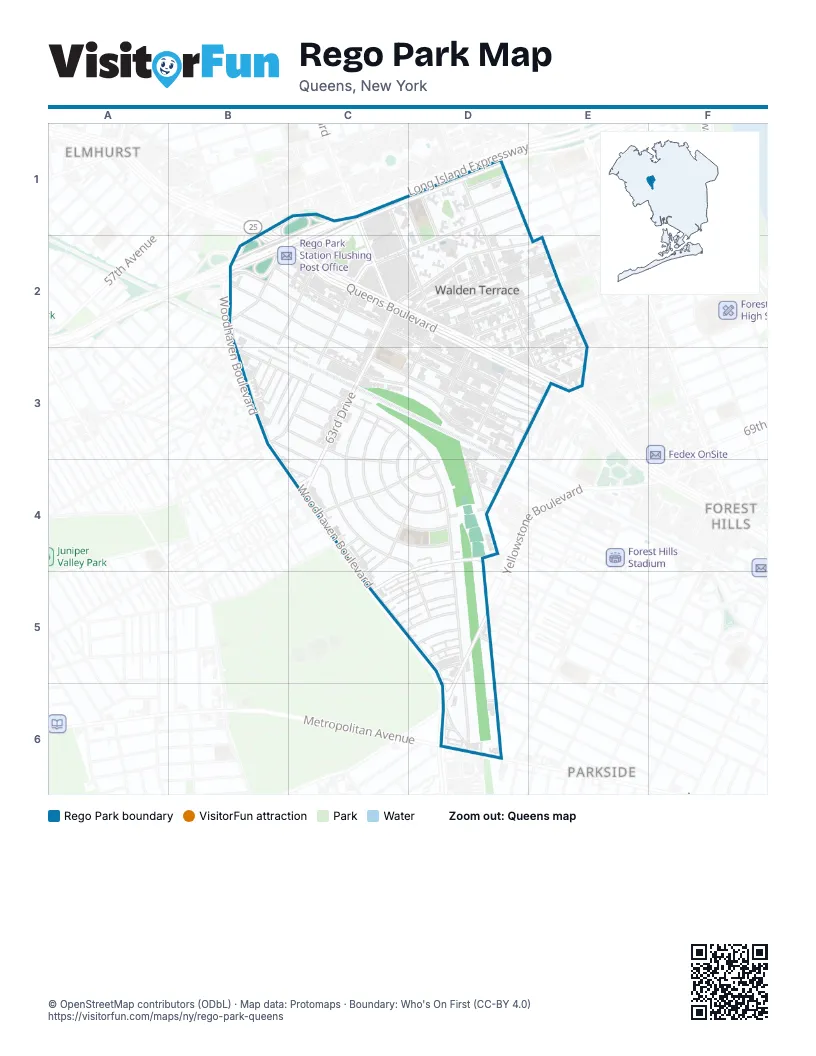
Street index of Rego Park
Each street on the sheet and the grid squares it crosses.
- 92nd StreetB1
- Queens BoulevardB1, B2, C2, D2, D3, E3
- 94th StreetC1
- 97th PlaceC1, D2
- 97th StreetC1, D2
- Horace Harding ExpresswayC1, D1, C2
- Junction BoulevardC1, C2
- Long Island ExpresswayC1, D1, B2, C2
- 62nd AvenueD1, B2, C2, B3
- 62nd RoadD1, B3
- 98th StreetD1, D2
- 99th StreetD1, D2, E3
- Austin StreetB2, C3, D3
- Booth StreetB2, C2, D3, E3
- Eliot AvenueB2, C2
- Saunders StreetB2, C2, E3
- Wetherole StreetB2, C2, D3
- Woodhaven BoulevardB2, B3, B4, C4, C5, D5, D6
- 62nd DriveC2, B3, C3
- 63rd AvenueC2, D2, B3, C3
- 63rd DriveC2, D2, C3, C4
- 63rd RoadC2, D2, E2
- 93rd StreetC2
- 64th AvenueD2
- 64th RoadD2, E2, C3, D3, C4, D4
- 65th AvenueD2, E2, C4
- 65th RoadD2, D3, C4
- 98th PlaceD2
- 102nd StreetE2, E3
- 66th AvenueE2, D3, E3, D4, C5
- Alderton StreetB3, C3, D3, D4, D5, D6
- Carlton StreetB3, C3, C4
- Fitchett StreetB3, C4, D4, D5
- Boelsen CrescentC3, D3, C4, D4
- Bourton StreetC3
- Cromwell CrescentC3, C4, D4
- Dieterle CrescentC3, C4, D4
- Ellwell CrescentC3, C4, D4
- Haring StreetC3
- 67th AvenueD3, E3, D4, C5, D5
- Asquith CrescentD3, D4
- 66th RoadE3, C5, D5
- Everton StreetB4, C4
- 65th DriveC4, D4, C5
- Furmanville AvenueC4
- Penelope AvenueC4
- Burns StreetD4
- Clyde StreetD4
- Dartmouth StreetD4
- Exeter StreetD4
- Fleet StreetD4
- Groton StreetD4
- Selfridge StreetD4
- Thornton PlaceD4
- 67th RoadC5, D5
- 67th DriveD5
- 68th AvenueD5
- 68th RoadD5
- Juno StreetD5
- Kessel StreetD5
- Yellowstone BoulevardD5, D6
- Nansen StreetD6
- Polo PlaceD6
- Trotting Course LaneD6
Places on the map
- 63rd Drive-Rego Park (M,R)
- Aldi
- Burger King
- C-Town
- Foodtown
- I&R Kosher Grocery
- Key Food
- Lost Batallion Playground
- Lost Battalion Hall Recreation Center
- NetCost Market
- Our Saviour Lutheran Church
- P.S. 139Q - The Rego Park School
- P.S. 206Q - The Horace Harding School
- P.S.174Q - William Sidney Mount School
- Park City Estates
- Petco
- Project Eden
- Real Good Park
- Rego Park Branch Queens Borough Public Library
- Rego Park Center
- Rego Park Jewish Center
- Rego Park Station Flushing Post Office
- The Compost Collective
- The UPS Store
- Thomas X. Winberry Garden
- Wendy's
Next to Rego Park
- Elmhurst map
- Forest Hills
- Parkside map
© OpenStreetMap contributors (ODbL) · Map data: Protomaps · Boundary: Who's On First (CC-BY 4.0)