

New York map
Parkside map
A printable two-page map of Parkside (Buffalo, New York), drawn by VisitorFun from OpenStreetMap. Page two is the street index: every street on the sheet with its grid square, the same list as below.
Open the map (PDF, US Letter)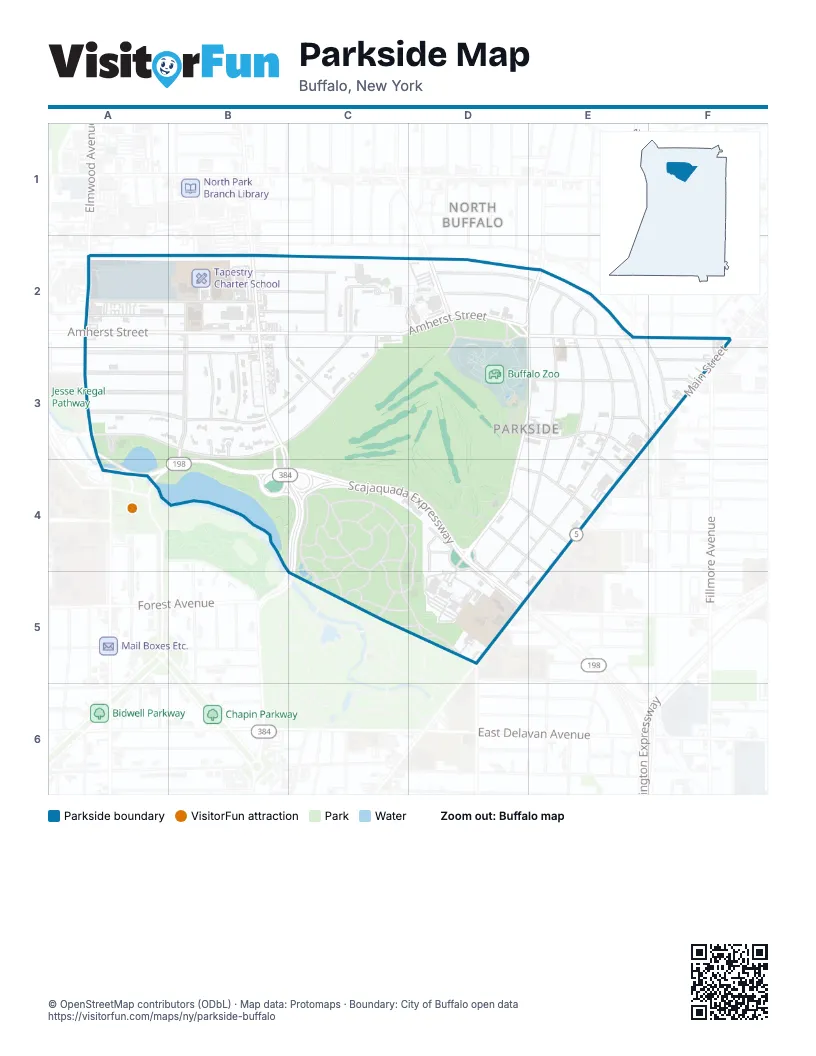
Street index of Parkside
Each street on the sheet and the grid squares it crosses.
- Amherst StreetA2, B2, C2, D2, E2
- Elmhurst PlaceA2, B2
- Great Arrow AvenueA2, B2
- Delaware AvenueB2, B3, B4, C4, C5
- Delham AvenueB2, C2
- Knox AvenueB2, C2
- Lincoln ParkwayB2, B3
- Meadow RoadB2, B3, C3
- Rand AvenueB2, C2
- Tim HortonsB2
- Edge Park AvenueC2
- Middlesex RoadC2, A3, B3, C3
- New Amsterdam AvenueC2
- Nottingham TerraceC2, A3, B3, C3
- Colvin AvenueD2
- Crandall CircleD2
- Crandall DriveD2
- Crandall RoadD2
- Crescent AvenueD2, E2, E3, D4, E4, D5
- Park Entrance RoadD2, D3
- Tillinghast PlaceD2, E2
- Duane TerraceE2
- Fairfield AvenueE2, F3
- Greenfield StreetE2, E3
- Parkside AvenueE2, D3, E3, D4
- Starin AvenueE2
- Summit AvenueE2, E3, E4
- Woodward AvenueE2, E3, D4, E4
- Parker AvenueF2, F3
- Voorhees AvenueF2
- Fordham DriveA3, B3
- Museum CourtA3
- Bedford AvenueB3
- Chatham AvenueB3
- Dana RoadB3
- Hallam RoadB3
- Middlebury LaneB3
- Randwood LaneB3
- Jewett ParkwayD3, E3
- Elam PlaceE3
- Russell StreetE3
- Willowlawn StreetE3
- Main StreetF3, E4, D5, E5
- Orchard PlaceF3
- Vernon PlaceF3
- Scajaquada ExpresswayA4, B4, C4, D4, D5
- Agassiz Cir AccessD4
- Agassiz CircleD4
- Agassiz Circle AccessD4, D5
- Burbank DriveD4
- Burbank TerraceD4, D5
- Florence AvenueD4, E4
- Humboldt ParkwayD4, D5
- Meadowview PlaceD4
- Robie AvenueD4
- Robie StreetD4, E4
- West Oakwood PlaceD4, E4
- Eastwood PlaceD5
- Kensington AvenueD5
Places on the map
- 7-Eleven
- 8/Twelve Convenience
- Addax
- Agassiz Circle
- Alice, Ever After Books
- America's Best Contacts & Eyeglasses
- Amherst Station
- Amherst Street
- Amphibian and Reptile House
- Arctic Fox
- Asia Hibachi & Rice Bowls
- Bald Eagle
- Bighorn Sheep
- Bison
- Bruegger's Bagels
- Buffalo and Erie County Historical Society
- Buffalo Equestrian Center
- Buffalo Zoo
- Canisius University
- Carousel (seasonal)
- Church's Texas Chicken
- City Creatures Animal Hospital
- CVS lot
- CVS Pharmacy
- Darwin D. Martin House
- Darwin D. Martin House Gift Shop
- Darwin Martin House
- Delaware
- Delaware Ave & Great Arrow Ave (SB)
- Delaware Ave & Rand Ave (NB)
- Delaware Ave. Apartments
- Delaware Park
- Delaware Park Apartments
- Delaware Park Basketball Courts
- Delaware Park Fitness Station
- Delaware Park Japanese Gardens
- Delaware Park Public Golf Course
- Dollar Tree
- Duncan Motor Car
- Edge Park Apartments
Next to Parkside
© OpenStreetMap contributors (ODbL) · Map data: Protomaps · Boundary: City of Buffalo open data