

New York map
Richmond Hill map
A printable two-page map of Richmond Hill (Queens, New York), drawn by VisitorFun from OpenStreetMap. Page two is the street index: every street on the sheet with its grid square, the same list as below.
Open the map (PDF, US Letter)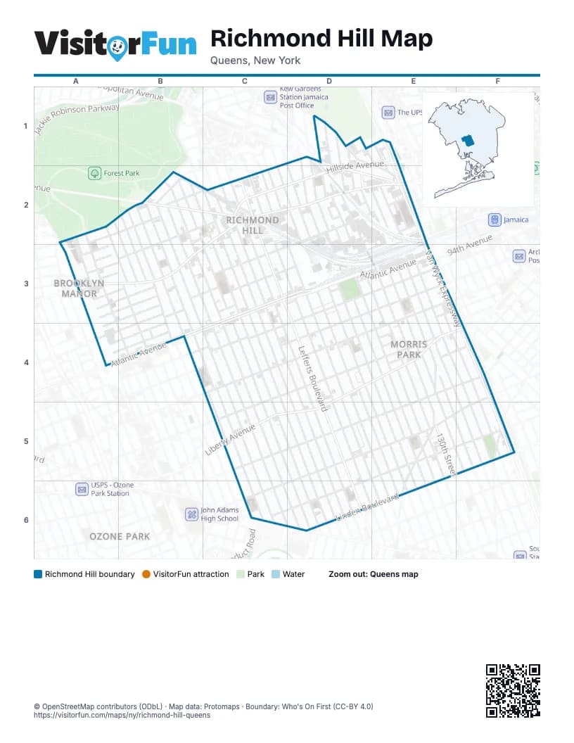
Street index of Richmond Hill
Each street on the sheet and the grid squares it crosses.
- 124th StreetC1, D2, D3, D4, E5, E6
- 127th StreetD1, D2, D3, E4, E5
- 129th StreetD1, D2, D3, E4, E5
- 130th StreetD1, D2, D3, E3, E4, E5
- 131st StreetD1, D2, E3, E4, E5
- 134th StreetD1, E2, E3, E4, F4, F5
- 135th StreetD1, E1, E2, E3, E4, F4, F5
- 86th RoadD1, A3
- 87th AvenueD1, E1, A3, B3
- Kew Gardens RoadD1, E1, E2
- Metropolitan AvenueD1, D2, E2
- Hillside AvenueE1, C2, D2
- Van Wyck ExpresswayE1, E2, E3, F4, F5
- Van Wyck Expressway WestE1, E2, F4, F5
- 101st StreetA2, A3
- 102nd StreetA2, A3
- 105th StreetA2, B3, B4
- 85th AvenueA2, B2, C2
- Freedom DriveA2
- Park Lane SouthA2, B2
- 106th StreetB2, B3
- 107th StreetB2, B3, B4
- 108th StreetB2, B3, B4, C4, C5, C6
- 109th StreetB2, B3, B4, C4, C5, C6
- 110th StreetB2, B3, B4, C4, C5, C6
- 111th StreetB2, B3, C4, C5, C6
- 112th StreetB2, B3, C3, C4, C5, C6
- 113th StreetB2, C3, C4, C5, D5, D6
- 114th StreetB2, C2, C3, C4, C5, D5, D6
- 115th StreetB2, C2, C3, C4, C5, D5, D6
- 84th AvenueB2
- 86th AvenueB2, C2, A3, B3
- Bessemer StreetB2, C2
- Myrtle AvenueB2, C2
- 116th StreetC2, C3, C4, D5, D6
- 117th StreetC2, C3, C4, D4, D5, D6
- 118th StreetC2, C3, C4, D5, D6
- 120th StreetC2, C3, D4, D5, D6
- 121st StreetC2, D3, D4, E5, E6
- 122nd StreetC2, D4, E5, E6
- 123rd StreetC2, D2, D3, D4, E5, E6
- Babbage StreetC2
- Jamaica AvenueC2, D2, E2, A3, B3, C3
- Lefferts BoulevardC2, C3, D3, D4, D5, D6
- 125th StreetD2, D3, D4, E5, E6
- 126th StreetD2, D3, E4, E5
- 132nd StreetD2, E2, E3, E4, E5
- 133rd StreetD2, E2, E3, E4, F5
- 87th RoadD2
- 88th AvenueD2, A3, B3
- 88th RoadD2
- 89th AvenueD2, E2, A3, B3, C3
- 89th RoadD2
- 90th AvenueD2, E2, A3, B3, A4
- 91st AvenueD2, E2, B3, C3, D3, A4, B4
- 136th StreetE2
- 92nd AvenueE2, B3, C3, D3, A4, B4
- 104th StreetA3, B3
- 85th DriveA3
- 85th RoadA3
- 98th StreetA3, A4
- 93rd AvenueC3, A4, B4
- 94th AvenueC3, D3, E3
- Atlantic AvenueC3, D3, E3, B4, C4
- 101st AvenueE3, C4
- 102nd AvenueE3, E4
- 95th AvenueE3, B4, C4
- 97th AvenueE3, C4, D4
- 103rd AvenueC4, E4
- Liberty AvenueD4, E4, F4, C5, D5
- 102nd RoadE4
- 103rd RoadE4
- 105th AvenueE4, F4
- 107th AvenueE4, F4, C5, D5, E5
- 128th StreetE4, E5
- Van Siclen StreetE4
- 109th AvenueF4, D5, E5, F5, C6
- 111th AvenueD5, E5, F5, C6, D6
- Hawtree Creek RoadE5, E6
- Linden BoulevardE5, F5, D6, E6
- Lincoln StreetF5
- Aqueduct RoadC6
Places on the map
- 104th Street
- 111st Street
- 121st Street
- AdvantageCare Physicians
- Apna Bazar
- Apna Bazar Farmers Market
- Atlantic Plaza
- Atlantis
- C-Town
- C‑Town Supermarkets
- Church of the Nazarene
- Citibank
- Congregation Beth Israel
- Custom Bandag
- DaVita Kidneycare
- Elohim Christian Church
- Epic High School North
- FDNY Engine 294/Ladder 143
- FDNY Engine 308
- Food Farm Supermarket
- Food Universe
- Frederick B. Judge Playground
- Full Gospel Assembly
- Gurdwara Sikh Temple
- Gurudwara Guru Bhagati Ghar
- Hillside Building Supply
- Jamaica Hospital Medical Center
- Jamaica Hospital Nursing Home
- Jamaica-Van Wyck (F)
- Key Food
- Kingdom Hall of Jehovahs Witnesses
- Lefferts Branch Queens Borough Public Library
- Maizteca
- Morris Park Engine Shop
- No Limit Auto Body
- Our Lady of Perpetual Help Catholic Academy
- P. S. 62Q - The Chester Park School
- P.S 121Q
- P.S. 100Q - Glen Morris Elementary School
- P.S. 108Q - The Captain Vincent G. Fowler School
Next to Richmond Hill
© OpenStreetMap contributors (ODbL) · Map data: Protomaps · Boundary: Who's On First (CC-BY 4.0)