

New York map
Sag Harbor map
About 2,816 people live here (Census Bureau, 2024 estimate). The sheet's index lists 122 streets; Division Street, Hampton Street and Madison Street cross the most grid squares. Also on it: 53 Lincoln St, American Hotel and Christ Episcopal Church.
Open the map (PDF, US Letter)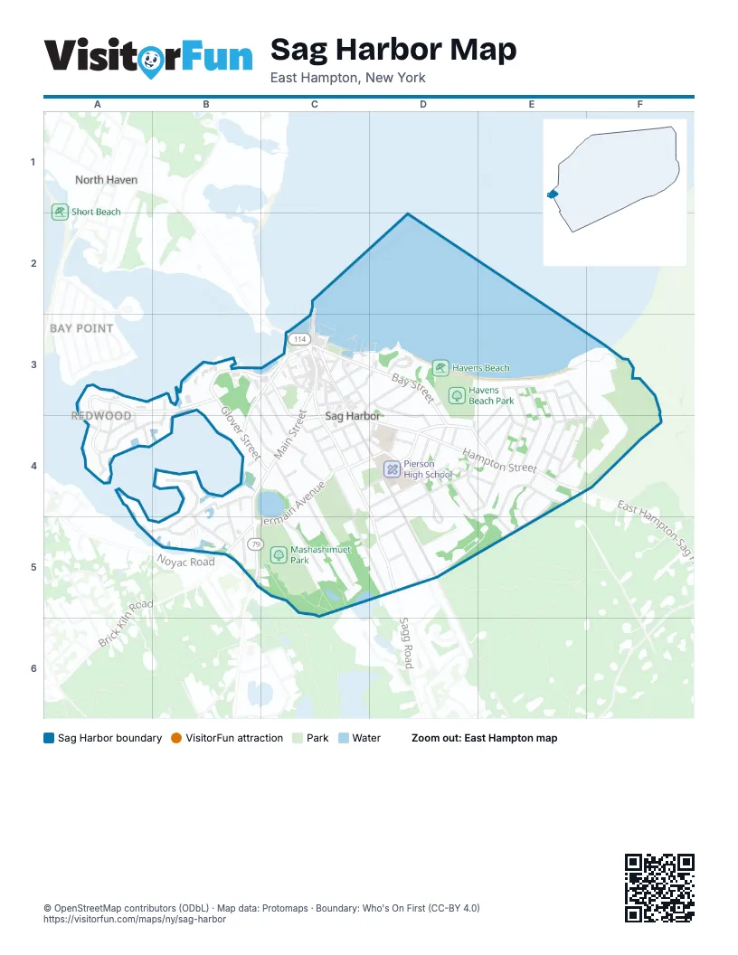
Street index of Sag Harbor
Each street on the sheet and the grid squares it crosses.
- Wharf StreetC2, C3
- Cornell RoadA3, A4
- Dartmouth RoadA3, A4
- Harvard RoadA3, A4
- Redwood RoadA3, B3, A4
- Cove RoadB3, B4
- Glover StreetB3, B4, C4
- Long Island AvenueB3, C3, B4
- Meadowlark LaneB3, C4
- West Water StreetB3, C3
- Bay StreetC3, D3, D4
- Bridge StreetC3
- Burke StreetC3
- Church StreetC3, C4
- Cross StreetC3
- Dering RoadC3, D3
- Division StreetC3, C4, D4, D5
- East Union StreetC3
- Ferry RoadC3
- Garden StreetC3, C4
- Hampton StreetC3, C4, D4, E4
- High StreetC3, D3, C4
- Howard StreetC3, C4
- Love LaneC3
- Madison StreetC3, C4, D4, D5
- Main StreetC3, B4, C4, B5
- Marine Park DriveC3
- Meadow StreetC3
- Nassau StreetC3
- Rector StreetC3
- Rose StreetC3
- Rysam StreetC3
- Sage StreetC3
- Spring StreetC3
- Union StreetC3, C4
- Washington StreetC3
- Franklin AvenueD3, D4
- Havens Beach RoadD3
- Prospect AvenueD3
- Beach AvenueE3, E4
- Cuffee DriveE3, E4
- Gull Rock RoadE3
- Harbor AvenueE3, E4
- Hillside Drive EastE3, E4, F4
- Hillside Drive WestE3, E4
- Meredith AvenueE3, E4
- Milton AvenueE3, E4
- Ninevah PlaceE3
- Richards DriveE3, D4
- Sound View DriveE3
- Terry DriveE3
- Walker AvenueE3, E4
- Harboy PlaceF3, E4, F4
- Amherst RoadA4
- Notre Dame RoadA4
- Princeton RoadA4
- South Redwood RoadA4, B4
- Yale RoadA4
- Bayview AvenueB4, C4
- Bluff Point LaneB4
- Bluff Point RoadB4, B5
- Columbia StreetB4, B5
- Green StreetB4
- Jessey Halsey LaneB4, B5
- John StreetB4, B5
- West Henry StreetB4
- Amity StreetC4
- Concord StreetC4
- Elizabeth StreetC4, D4
- Grand StreetC4, D4
- Henry StreetC4
- Jefferson StreetC4
- Jermain AvenueC4, D4, B5, C5
- Joels LaneC4, C5
- Latham StreetC4
- Marsden StreetC4, D4
- Oakland AvenueC4
- Palmer TerraceC4
- Rogers StreetC4
- Somers PlaceC4
- Suffolk StreetC4, C5, D5
- White StreetC4
- Williams StreetC4
- Ackerly StreetD4
- Atlantic AvenueD4
- Carver StreetD4, E4
- Clinton StD4
- Clinton StreetD4
- Downer PlaceD4
- Eastville AvenueD4
- Hamilton AvenueD4
- Harrison StreetD4, D5
- Harrison Street ExtensionD4
- Hempstead StreetD4, E4
- James PlaceD4
- Liberty StreetD4
- Lighthouse LaneD4, E4
- Montauk AvenueD4, D5
- Robeson BoulevardD4, E5
- Shaw RoadD4
- Vickers StreetD4
- Washington AvenueD4, E4
- Brandywine DriveE4, E5
- Cadmus RoadE4
- Deerfield DriveE4
- Hillcrest DriveE4
- Hillside DriveE4
- Horizon DriveE4, E5
- Wildwood DriveE4, E5
- Long Point RoadA5, B5
- Brick Kiln RoadB5
- Fordham StreetB5
- Havens LaneB5
- Morris Cove LaneB5
- Archibald WayC5
- Collingswood DriveD5
- Denison RoadD5
- Forrest StreetD5
- Middle Line HighwayD5, E5
- Sagg RoadD5
- Susan StreetD5
- Town Line RoadD5
Places on the map
- 53 Lincoln St
- American Hotel
- Christ Episcopal Church
- First Presbyterian Church
- Havens Beach
- Havens Beach Park
- Havens Beach Road
- John Jermain Memorial Library
- John Steinbeck Waterfront Park
- Marine Park
- Mashashimuet Park
- Oakland Cemetery
- Otter Pond
- Pierson High School
- Sag Harbor Elementary School
- Sag Harbor Fire Department
- Sag Harbor Inn
- Sag Harbor Post Office
- Sag Harbor Village Hall
- Sag Harbor Whaling Museum
- Saint Andrews Roman Catholic Church
- Temple Adas Israel
- Village of Sag Harbor
- Windmill Beach
Next to Sag Harbor
- Bay Point
- North Haven
© OpenStreetMap contributors (ODbL) · Map data: Protomaps · Boundary: Who's On First (CC-BY 4.0)