

New York map
Schenectady County map
About 162,261 people live here (Census Bureau, 2024 estimate). The sheet's index lists 54 streets; State Highway 30, New York State Thruway and Duanesburg Road cross the most grid squares. Also on it: Alplaus Kill Preserve, Amy Lemaire Woods and Andersen Park.
Open the map (PDF, US Letter)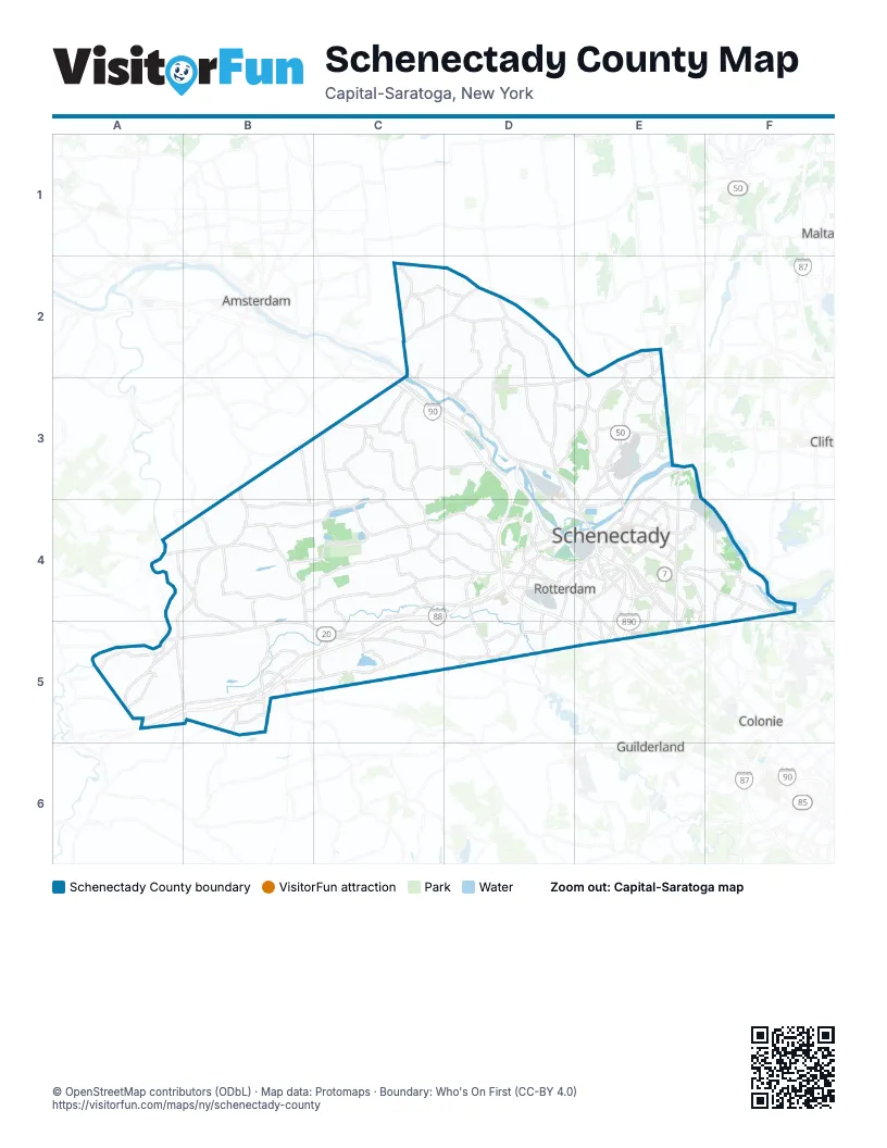
Maps inside Schenectady County
1 map inside, from the street map of Schenectady County down.
Street index of Schenectady County
Each street on the sheet and the grid squares it crosses.
- Mohawk TurnpikeC2, C3
- Sacandaga RoadD2, D3, D4
- Saratoga RoadE2, E3
- State Highway 30B3, A4, B4, A5
- Amsterdam RoadC3, D3
- Main StreetC3, D3, B5
- Mariaville Scotch Church RoadC3, C4
- New York State ThruwayC3, D3, D4, E5
- Pattersonville-Scotch Church RoadC3
- Scotch Church RoadC3
- Bridge StreetD3
- Mohawk AvenueD3, D4, E4
- River RoadD3
- Ballston RoadE3
- Balltown RoadE3, E4
- Freemans Bridge RoadE3, E4
- Glenridge RoadE3
- North Ballston AvenueE3, E4
- Mariaville RoadB4, C4, D4
- Duanesburg RoadC4, D4, B5, C5
- South Schenectady-Mariaville RoadC4
- BroadwayD4, E4
- Burdeck StreetD4
- Curry RoadD4, E4, E5
- Guilderland AvenueD4, D5
- Rice RoadD4
- West Campbell RoadD4
- Altamont AvenueE4
- Brandywine AvenueE4
- California AvenueE4
- Crosstown ConnectionE4
- Duane AvenueE4
- Erie BoulevardE4
- Hamburg StreetE4, E5
- Michigan AvenueE4
- Nott StreetE4
- South Brandywine AvenueE4
- State StreetE4, E5
- Troy Schenectady RoadE4, F4
- Union StreetE4
- Washington AvenueE4
- Western Gateway BridgeE4
- Duanesberg RoadA5, B5
- Esperance-Esperance Station RoadA5
- Esperance-Schoharie County Line RoadA5
- State Route 30A5
- Western TurnpikeA5, B5, C5, D5
- Central Bridge RoadB5
- Duanesburg Quaker Street RoadB5
- Schenectady Duanesburg RoadC5
- Gifford Church RoadD5
- Guilderland RoadD5
- Carman RoadE5
- Central AvenueE5
Places on the map
- Alplaus Kill Preserve
- Amy Lemaire Woods
- Andersen Park
- Aqueduct Park
- Bard Farms
- Bass Lake
- Blatnick Park
- Briar Creek Golf Course
- Cambridge Manor
- Catherine's Woods
- Central Park
- Christiana Open Space
- Christman Bird and Wildlife Sanctuary
- City of Schenectady
- Collins Creek
- Collins Lake
- Collins Park
- Community Center Park
- Conor Island
- Country Club
- Cranesville Block Company
- Crosstown Plaza
- Delta Pond
- Duane Lake
- Duanesburg
- Duanesburg Reservoir
- Duanesburg Town Forest
- East Glenville
- Edison Woods
- Ellis Health Center
- Ellis Hospital
- Enlarged Erie Canal
- Environment One Corporation
- Featherstonhaugh Lake
- Featherstonhaugh State Forest
- Fieldstone Park
- Frosty Acres Campground
- GE Global Research Center
- GE Vernova
- General Electric
Next to Schenectady County
- Amsterdam
- Colonie
- Guilderland
- Malta
© OpenStreetMap contributors (ODbL) · Map data: Protomaps · Boundary: Who's On First (CC-BY 4.0)