

New York map
South Ozone Park map
A printable two-page map of South Ozone Park (Queens, New York), drawn by VisitorFun from OpenStreetMap. Page two is the street index: every street on the sheet with its grid square, the same list as below.
Open the map (PDF, US Letter)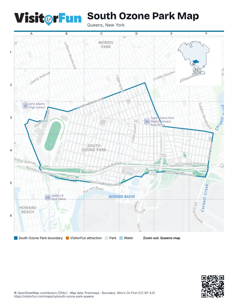
Street index of South Ozone Park
Each street on the sheet and the grid squares it crosses.
- 123rd StreetC2, C3, C4, C5
- 127th StreetC2, D3, C4, D4, C5
- Hawtree Creek RoadC2, C3, C4
- 115th AvenueD2, C3
- 116th AvenueD2, C3, D3
- 128th StreetD2, D3, D4, C5, D5
- 130th StreetD2, D3, D4, D5
- 131st StreetD2, D3, D4, D5
- 132nd StreetD2, D3, D4, D5
- 133rd StreetD2, D3, D4
- 134th StreetD2, D3, D4, D5
- 135th StreetD2, D3, E3, D4, E4
- Lincoln StreetD2, D3
- Van Wyck ExpresswayD2, D3, E3, E4, E5
- Aqueduct RoadA3, A4, A5, B5
- Centreville StreetA3
- Linden BoulevardA3, B3
- Peconic StreetA3
- Pitkin AvenueA3
- 109th StreetB3
- 110th StreetB3
- 111th StreetB3
- 112th StreetB3
- 114th PlaceB3, B4, B5
- 114th StreetB3, B4, B5
- 115th StreetB3, B4, B5
- 116th StreetB3, B4, B5
- 133rd AvenueB3, C4, D4, E4, F4
- Rockaway BoulevardB3, C3, D3, E3, F3
- Sutter AvenueB3, C3, D3, D4, E4, F4
- 117th StreetC3, B4, B5
- 118th StreetC3, B4, C4, B5
- 120th StreetC3, C4, C5
- 121st StreetC3, C4, C5
- 122nd PlaceC3, C4, C5
- 122nd StreetC3, C4, C5
- 124th StreetC3, C4, C5
- 125th StreetC3, C4, C5
- 126th StreetC3, D3, C4, C5
- Lefferts BoulevardC3, C4, B5
- 117th RoadD3
- 120th AvenueD3, E3
- 129th StreetD3, D4, D5
- Cedric RoadD3
- Foch BoulevardD3
- Gotham RoadD3
- 135th PlaceE3, E4
- 140th StreetE3, E4
- 142nd PlaceE3
- 142nd StreetE3, E4
- 143rd StreetE3, E4
- 144th StreetE3, E4
- Alwick RoadE3
- Bascom AvenueE3
- Linden AvenueE3
- 145th StreetF3, E4, F4
- 146th StreetF3, F4
- 147th StreetF3, F4
- 149th StreetF3, F4
- Inwood StreetF3, F4
- Aqueduct Access RoadA4
- North Conduit AvenueA4, C4, D4, E4, F4, A5, B5, C5
- 135th AvenueB4, C4, D4, E4, F4
- 149th AvenueB4, C4, D4, D5
- 150th AvenueB4, C4, C5, D5
- Old South RoadB4, B5, C5, D5
- Belt ParkwayC4, D4, A5, B5, C5, D5, E5, F5
- 130th PlaceD4
- 131st AvenueD4, E4
- 134th AvenueD4, E4
- 134th PlaceD4
- 135th RoadD4
- 129th AvenueE4, F4
- 130th AvenueE4, F4
- 132nd AvenueE4
- Nassau ExpresswayE4, F4, A5, B5, C5, D5, E5, F5
- 148th StreetF4
- 150th StreetF4, F5
- 152nd AvenueC5, D5
- South Conduit AvenueC5, D5, E5, F5
Places on the map
- 114th Street & Rockaway Boulevard
- 114th Street & Sutter Avenue
- 130th Street & 133rd Avenue
- 130th Street & 135th Avenue
- 130th Street & 150th Avenue
- 130th Street & Sutter Avenue
- 133rd Avenue & 115th Street
- 133rd Avenue & 116th Street
- 133rd Avenue & Lefferts Boulevard
- 135th Avenue & 125th Street
- 135th Avenue & 126th Street
- 135th Avenue & 142nd Street
- 142 Best Super Deli Grocery
- 143rd Street & 130th Avenue
- 143rd Street & 135th Avenue
- 143rd Street & Rockaway Avenue
- 143rd Street & Sutter Avenue
- 150th Avenue & 149th Avenue
- 150th Street & 130th Avenue
- 150th Street & 133rd Avenue
- 150th Street & Sutter Avenue
- 4 Milli Cafe & Caribbean Cuisine
- 49 Mini Mart
- 49 Quality 24h
- 5th Liquor Store
- 7 eleven
- A.N.M Super Clean
- AA
- Advance Auto Parts
- Aqueduct Mass Vaccination Site
- Aqueduct Racetrack
- AutoZone
- Barbershop
- Baskin-Robbins
- Baychu Driving School
- Bob's Discount Liquors
- Boost Mobile
- BP
- Catholic War Veterans Square
- Chew the Fat
Next to South Ozone Park
- Cedar Manor
- Howard Beach map
- Morris Park map
© OpenStreetMap contributors (ODbL) · Map data: Protomaps · Boundary: Who's On First (CC-BY 4.0)