

New York map
South Park map
A printable two-page map of South Park (Buffalo, New York), drawn by VisitorFun from OpenStreetMap. Page two is the street index: every street on the sheet with its grid square, the same list as below.
Open the map (PDF, US Letter)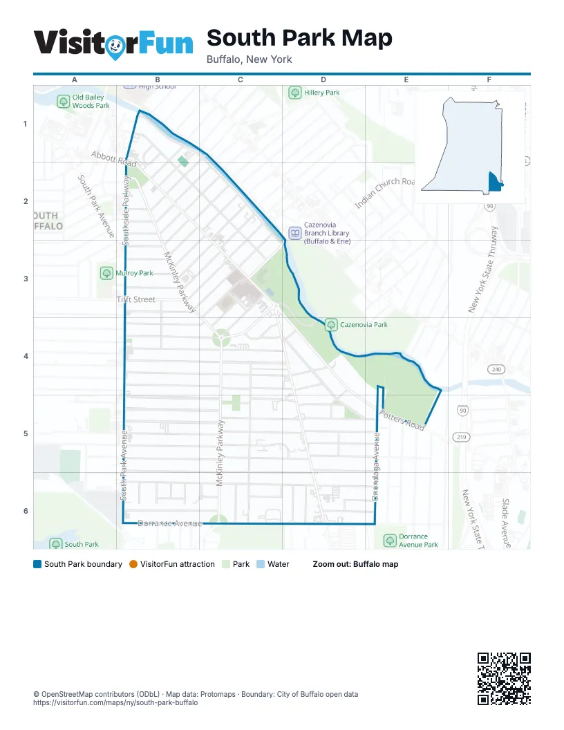
Street index of South Park
Each street on the sheet and the grid squares it crosses.
- Abbott RoadB1, B2, C2, C3, D4, D5, D6
- Albion PlaceB1
- Almont PlaceB1
- Cumberland AvenueB1, B2, C2, C3
- Marbeth CourtB1, B2
- McKinley ParkwayB1, B2, B3, C4, C5, C6
- Mumford StreetB1, B2
- South Legion DriveB1, C1, C2, D3
- Southside ParkwayB1
- Stevenson StreetC1, B2
- Clio AvenueB2
- Como AvenueB2, B3
- Hubbell AvenueB2
- Kenefick AvenueB2, B3
- Lakewood AvenueB2
- Melrose StreetB2, C2
- Mesmer AvenueB2
- Milford StreetB2, C2
- Robins StreetB2
- Rutland StreetB2, C2
- Athol StreetC2, C3
- Eaglewood AvenueC2, B3
- Meriden StreetC2, C3
- Portland StreetC2
- Salem StreetC2, C3
- Tamarack StreetC2
- Alsace AvenueB3, C3
- Columbus AvenueB3, C3
- Crystal AvenueB3
- Edgewood AvenueB3, C3
- Ithaca StreetB3, B4
- Olcott AvenueB3
- Richfield AvenueB3
- Strathmore AvenueB3, C3
- Tifft StreetB3
- Belvedere RoadC3, C4
- Cazenovia StreetC3, D3
- Choate AvenueC3, B4, C4
- Choate Avenue EastC3
- Lorraine AvenueC3, C4
- Mercy StreetC3
- Potters RoadC3, D3, D4, D5, E5
- Red Jacket ParkwayC3, C4
- Warren Spahn WayC3, D3, D4
- Altruria StreetB4
- Amber StreetB4
- Bloomfield AvenueB4, C4
- Ladner AvenueB4
- Lockwood AvenueB4
- Mariemont AvenueB4, C4
- Reading AvenueB4
- Sheffield AvenueB4, C4
- South Park AvenueB4, B5, B6
- West Woodside AvenueB4
- Whitfield AvenueB4, C4, D4
- Woodside AvenueB4, C4, D4
- Coolidge RoadC4, D4
- Hancock AvenueC4, C6
- Magnolia AvenueC4
- McClellan CircleC4
- Oakhurst AvenueC4
- Ramona AvenueC4, D4
- Tuscarora RoadC4, D4, D5, E5
- Minnetonka RoadD4
- Niantic StreetD4, D5
- Peconic StreetD4
- Ashton PlaceB5
- Cantwell DriveB5, C6
- Colgate AvenueB5
- Culver RoadB5, C5
- Eden StreetB5, C5, D5
- Harding RoadB5, C5
- Marilla StreetB5, C5
- Ridgewood RoadB5, C5
- Arbor LaneC5, D5
- Brost DriveC5, D5
- Hollywood AvenueC5, D5
- Kimberly AvenueC5, D5
- Morgan RoadC5
- Okell StreetC5
- Whitehall AvenueC5, D6
- Beale StreetD5
- Carlyle AvenueD5, E5
- Cushing PlaceD5
- Densmore StreetD5
- Dundee StreetD5, E5
- Narragansett RoadD5
- Shenandoah RoadD5, E5
- Onondaga AvenueE5, E6
- Aldrich PlaceB6, C6
- Augusta StreetB6
- Dallas RoadB6
- Downing StreetB6, C6, D6, E6
- Evanston PlaceB6
- Hines StreetB6
- Julius StreetB6
- Leland DriveB6
- Sibley StreetB6
- Dorrance AvenueC6, D6
- High View TerraceC6
- Latona CourtC6
- McKinley CircleC6
- Susan LaneC6
- Britt AvenueD6, E6
- Hansen AvenueD6
- South Shore BoulevardD6
- St Martins PlaceD6
- Turner AvenueD6, E6
- Ward CourtD6
Places on the map
- Brookdale Park
- Cazenovia Park Golf Course
- Cazenovia Pool
- Dudley Branch Library
- Heacock Park
- KFC
- Lorraine Elementary School
- McClellan Circle
- Mercy Hospital of Buffalo
- Saint Martin of Tours Catholic Church
- Sisters of Mercy Convent
- South Legion & Cazenovia
- Tosh Collins Community Center
- Trocaire College
- Tuscarora Triangle
Next to South Park
© OpenStreetMap contributors (ODbL) · Map data: Protomaps · Boundary: City of Buffalo open data