

New York map
University Heights map
A printable two-page map of University Heights (Buffalo, New York), drawn by VisitorFun from OpenStreetMap. Page two is the street index: every street on the sheet with its grid square, the same list as below.
Open the map (PDF, US Letter)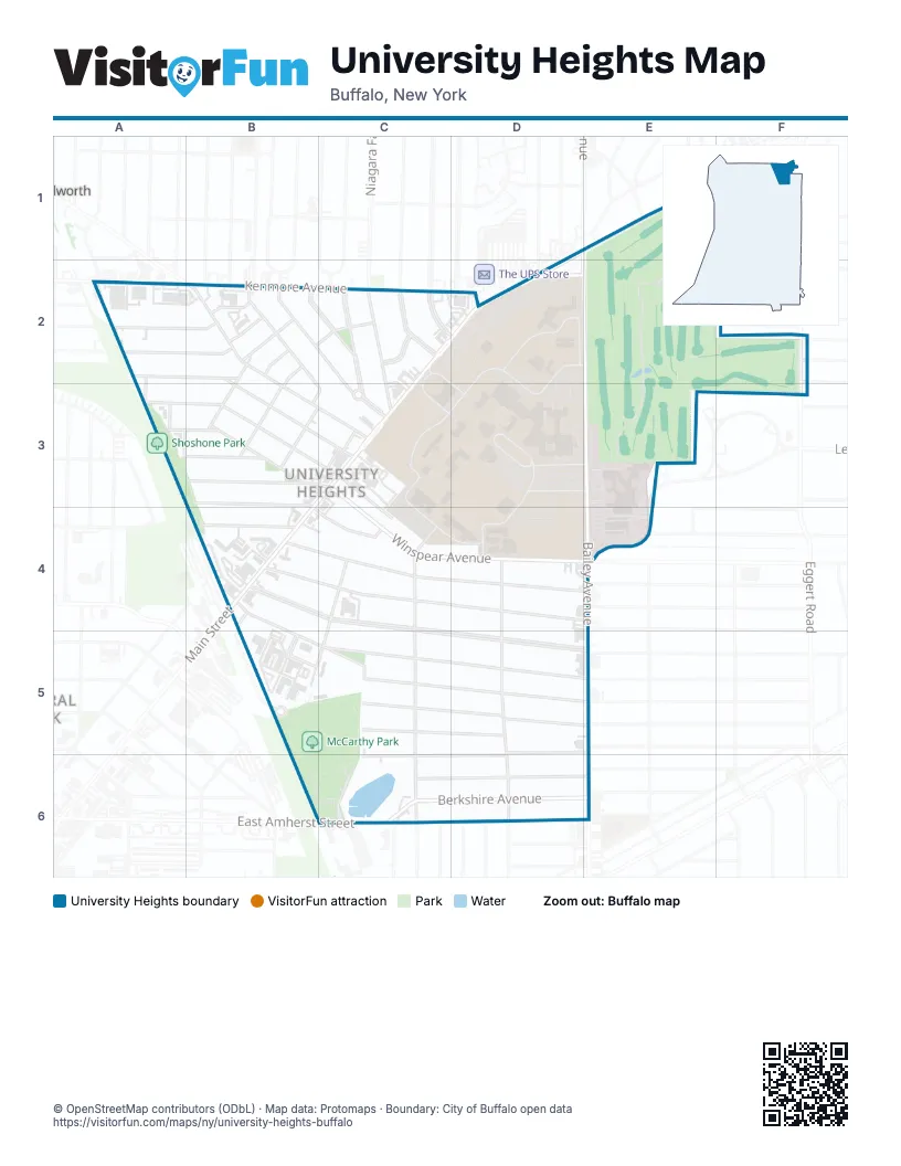
Street index of University Heights
Each street on the sheet and the grid squares it crosses.
- Main StreetD1, E1, C2, D2, C3, B4
- Crosby CircleE1
- Longleat DriveE1
- Park CircleE1
- Angle StreetA2, A3
- Brinton StreetA2, B2
- Fairfield AvenueA2
- Bellevue AvenueB2, C2
- Claremont AvenueB2
- Devereaux AvenueB2
- Eley PlaceB2, B3
- Englewood AvenueB2, B3, C3
- Evadene StreetB2
- Heath StreetB2, B3, C3
- Martha Jackson PlaceB2
- Mildred StreetB2, B3
- Montcalm StreetB2
- Montrose AvenueB2, B3, C3
- Nicholson StreetB2
- Radcliffe RoadB2, C2
- University AvenueB2, C2, C3
- Wendel AvenueB2
- Allenhurst RoadC2
- Capen BoulevardC2, D2
- Kenmore AvenueC2, D2
- Larchmont RoadC2, C3
- Main CircleC2, C3, D3
- Niagara Falls BoulevardC2, C3
- Pelham DriveC2
- Callodine AvenueD2
- Goodyear RoadD2
- Hayes RoadD2, C3, D3, C4, D4
- Main-Bailey LoopD2
- Michael RoadD2, E2, D3
- Springville AvenueD2
- Bailey AvenueE2, E3, E4, E5, E6
- Cornell AvenueF2
- Eggert RoadF2
- Layton AvenueF2
- Lennox AvenueF2
- Flower StreetA3, B3
- Merrimac StreetA3, B3, C3
- Tyler StreetA3, B3
- Bruce StreetB3
- Cornell StreetB3
- West Northrup PlaceB3, B4
- West Winspear AvenueB3, C3
- Coyle AlleyC3
- Sutton LaneC3, C4
- University CircleC3
- Winspear AvenueC3, C4, D4, E4
- Coal RoadD3, E3
- Diefendorf LoopD3
- Diefendorf RoadD3, E3
- Lebrun RoadE3, E4
- Custer StreetB4
- Highgate AvenueB4, C4, D4
- Lasalle AvenueB4, B5, C5, D5, E5
- Lisbon AvenueB4, C4, D4, E4
- Minnesota AvenueB4, C4, D5, E5
- Northrup PlaceB4, C4
- William Price ParkwayB4, B5
- Cordova AvenueC4, B5, C5
- Parkridge AvenueC4, C5, C6
- Winridge RoadC4
- Comstock AvenueD4, D5, D6
- Rotary RoadD4
- Rounds AvenueE4
- Camelot CourtC5
- Dartmouth AvenueC5, D5, E5
- Dunlop AvenueC5, D5
- Range AvenueC5
- Shirley AvenueC5, D5, E5
- Hewitt AvenueD5, E5, C6, D6
- Berkshire AvenueC6, D6, E6
- Buckingham PlaceC6
- Stockbridge AvenueC6, D6, E6
- East Amherst StreetE6
Places on the map
- @ Eleven Wings & Cuisines
- 416 Kenmore Ave (EB)
- 7-Eleven
- 99 Fast Food Restaurant
- Abbot
- Abbot A Lot (f/s,st)
- Abbott Quad
- ABC Hardware, Rental & Special Events
- ALDI
- Allen Lot (f/s,st)
- Amherst Quarry Lake
- Amy's Place
- An Chau Asian Market
- Automotive Battery & Tire
- Axis 360 Apartments
- Bailey Seafood
- Baitul Mukarram Jame Masjid
- Bank of America
- Buffalo Calzones
- Buffalo Combat Fitness
- Buffalo Delights
- Buffalo Fire Station Engine 23
- Buffalo Roots Hydroponics & Organics
- Buffalo VA Medical Center
- Burger Authority
- C Training
- Campus Compass
- Campus Laundromat
- China Jade
- Clark Lawn
- Clark Lot (st,f/s*)
- Clement Hall
- Cornerstone Community Church
- CVS Pharmacy
- Diefendorf Loop
- Diefendorf Lot (f/s,st)
- Diefendorf Quad
- Distinct Boot Camp
- Doctor Bird
- Dollar General
Next to University Heights
- Kenilworth
© OpenStreetMap contributors (ODbL) · Map data: Protomaps · Boundary: City of Buffalo open data