

New York map
Upper West Side map
A printable two-page map of Upper West Side (Buffalo, New York), drawn by VisitorFun from OpenStreetMap. Page two is the street index: every street on the sheet with its grid square, the same list as below.
Open the map (PDF, US Letter)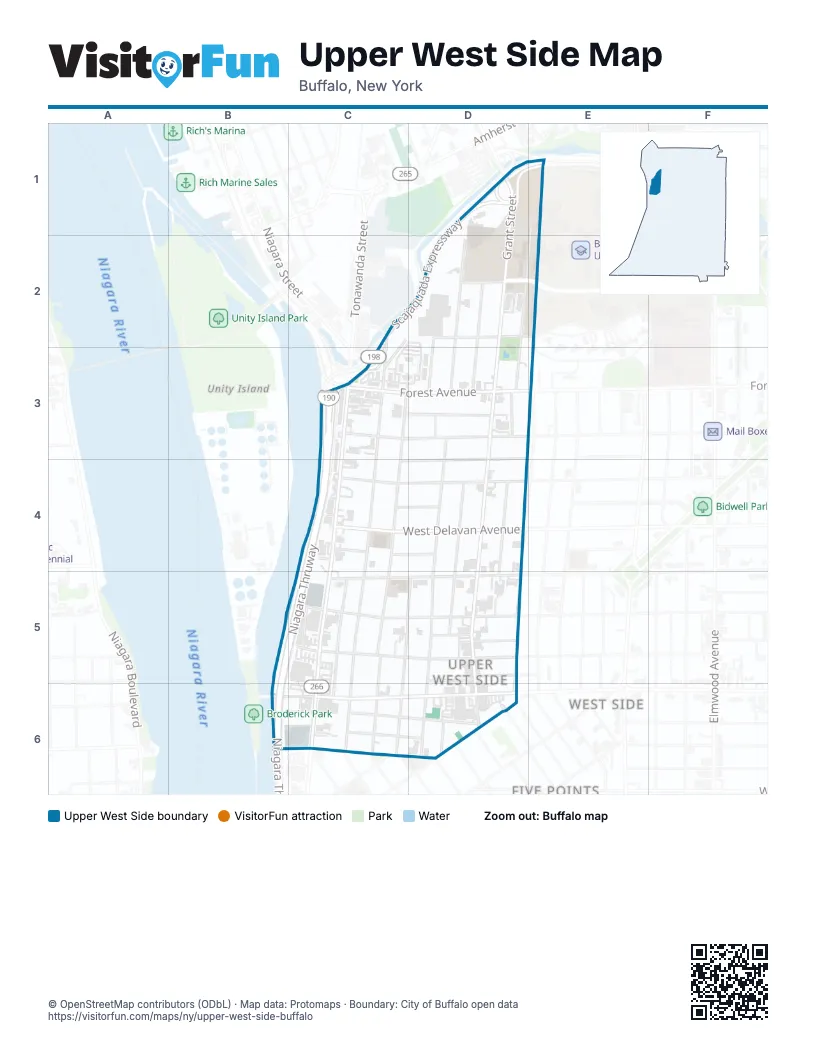
Street index of Upper West Side
Each street on the sheet and the grid squares it crosses.
- Bengal DriveD1, E1
- Grant StreetD1, D2, D3, D4, D5, D6
- Iroquois DriveD1, E1
- Scajaquada ExpresswayD1, E1, C2, D2, C3
- Rees StreetE1, D2, E2, D3
- Fernwood AvenueC2, C3
- West AvenueC2, C3, C4, C5, C6
- Bradley StreetD2
- Danforth StreetD2, D3
- Dart StreetD2, D3
- Hawley StreetD2, D3
- Letchworth StreetD2
- Rockwell RoadD2, E2
- Bird AvenueC3, D3
- Dewitt StreetC3, C4, C5
- Forest AvenueC3
- Niagara ThruwayC3, C4, B5, C5, B6
- Pooley PlaceC3, D3
- Barry PlaceD3
- Cordage AlleyD3
- Herkimer StreetD3, D4, D5, D6
- Brace StreetC4
- Garner AvenueC4
- Helen StreetC4, D4
- Niagara StreetC4, C5, C6
- Penfield StreetC4
- Perkins PlaceC4, D4
- Potomac AvenueC4, D4
- Sloan StreetC4
- West Delavan AvenueC4
- Congress StreetD4, D5
- Greenwood PlaceD4, D5
- Auburn AvenueC5
- Barton StreetC5, D5
- Breckenridge StreetC5, D5
- Gelston StreetC5, C6
- Lafayette AvenueC5, D5
- Plymouth AvenueC5
- Arnold StreetD5
- Auchinvole AvenueD5
- Boyd StreetD5
- Ferguson AvenueD5
- Parkdale AvenueD5, D6
- Gull AlleyB6, C6
- Robert Rich WayB6, C6
- Arkansas StreetC6, D6
- California StreetC6, D6
- Haggart AlleyC6
- West Ferry StreetC6
- 18th StreetD6
- Hampshire StreetD6
- Sherwood StreetD6
- Winter StreetD6
Places on the map
- 5 Loaves Farm
- African Market
- Asarese-Matters Community Center
- Buffalo Dream Center
- Buffalo State Bengals
- Bungtla Asian Market
- Cookie
- Coronation of the Blessed Virgin Mary
- Family Dollar
- First Line
- Greenwood Garden
- Guercio & Sons
- Hatimy Market
- Kat Food Market
- KeyBank
- Kingdom Hall of Jehovah’s Witnesses
- La Nova
- Lot G-20
- Lot G-24
- Marka Halal Market
- Monarch 716
- O & A The Corner Store
- Our Lady of Hope Catholic Church
- Rees Street Pool
- Taqueria Ranchos La Delicias
- West Side Buffalo Post Office
- West Side Plaza
Next to Upper West Side
- Elmwood Village
- Five Points
- West Side map
© OpenStreetMap contributors (ODbL) · Map data: Protomaps · Boundary: City of Buffalo open data