

Ohio road map
I-75 in Ohio map
I-75 is about 206 miles in Ohio. It has 118 exits, from Exit 1A at mile 0 to Exit 210 at mile 205. It meets 67 highways; OH 4, OH 65 and OH 25 meet it in the most grid squares.
Open the map (PDF, US Letter)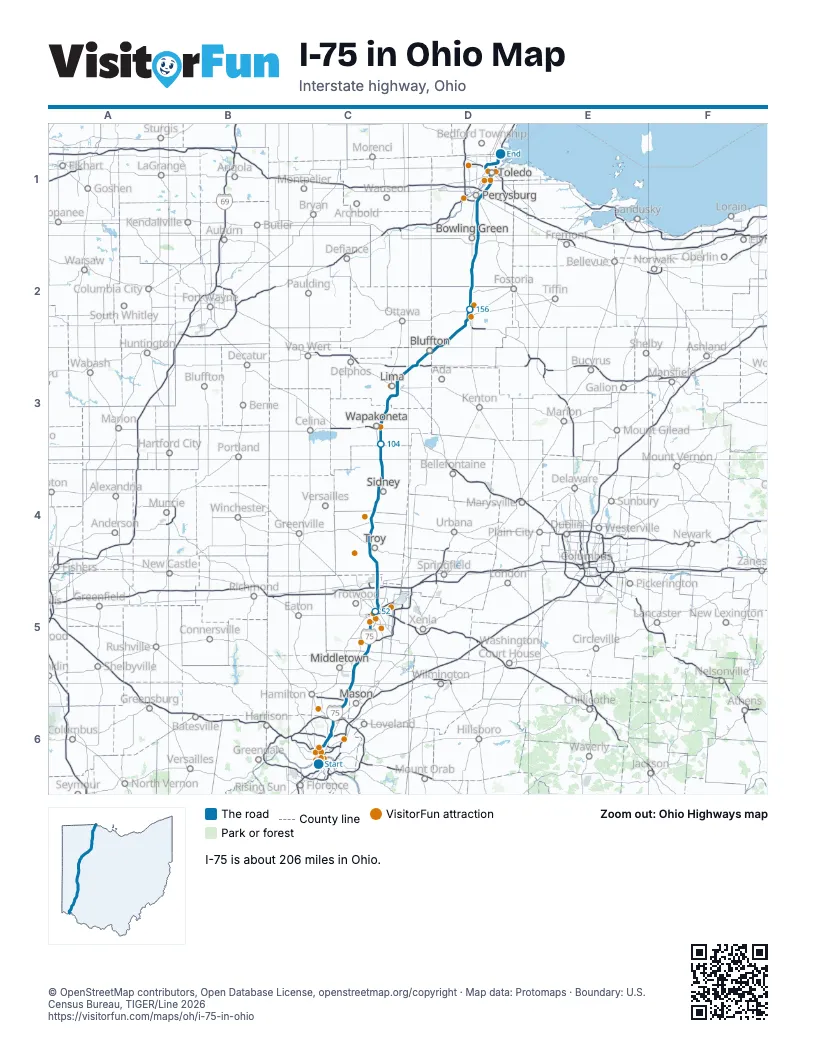
Exits on I-75 in Ohio
Each exit in mile order, with its grid square.
- Exit 1Amile 0, C6
- Exit 1Bmile 0, C6
- Exit 1Cmile 0, C6
- Exit 1Dmile 0, C6
- Exit 1Emile 1, C6
- Exit 1Fmile 1, C6
- Exit 1Gmile 1, C6
- Exit 2Amile 2, C6
- Exit 2mile 2, C6
- Exit 2Bmile 2, C6
- Exit 4mile 3, C6
- Exit 3mile 3, C6
- Exit 6mile 5, C6
- Exit 7mile 7, C6
- Exit 8mile 7, C6
- Exit 9mile 9, C6
- Exit 10Amile 9, C6
- Exit 27Bmile 9, C6
- Exit 10Bmile 9, C6
- Exit 27mile 10, C6
- Exit 10mile 10, C6
- Exit 12mile 11, C6
- Exit 13mile 12, C6
- Exit 14mile 13, C6
- Exit 14A-Bmile 13, C6
- Exit 15mile 14, C6
- Exit 16mile 15, C6
- Exit 43Bmile 15, C6
- Exit 43Amile 15, C6
- Exit 16Amile 16, C6
- Exit 16Bmile 16, C6
- Exit 19mile 18, C6
- Exit 21mile 19, C6
- Exit 22mile 21, C6
- Exit 24mile 22, C6
- Exit 25Bmile 23, C6
- Exit 29mile 28, C6
- Exit 32mile 31, C5
- Exit 36mile 36, C5
- Exit 38mile 37, C5
- Exit 41mile 40, C5
- Exit 43mile 41, C5
- Exit 44mile 43, C5
- Exit 47mile 46, C5
- Exit 50Amile 48, C5
- Exit 50Bmile 49, C5
- Exit 51mile 50, C5
- Exit 52mile 51, C5
- Exit 53mile 52, C5
- Exit 54Bmile 52, C5
- Exit 54Amile 53, C5
- Exit 56mile 54, C5
- Exit 57mile 55, C5
- Exit 58mile 56, C5
- Exit 59mile 58, C5
- Exit 61mile 59, C5
- Exit 63mile 61, C5
- Exit 64mile 62, C5
- Exit 68mile 66, C4
- Exit 69mile 68, C4
- Exit 73mile 71, C4
- Exit 74mile 73, C4
- Exit 78mile 76, C4
- Exit 82mile 80, C4
- Exit 83mile 81, C4
- Exit 90mile 88, C4
- Exit 92mile 89, C4
- Exit 93mile 91, C4
- Exit 94mile 93, C4
- Exit 99mile 97, C4
- Exit 102mile 100, C3
- Exit 104mile 102, C3
- Exit 110mile 108, C3
- Exit 38Amile 108, C3
- Exit 111mile 109, C3
- Exit 113mile 111, C3
- Exit 118mile 116, C3
- Exit 120mile 118, C3
- Exit 122mile 120, C3
- Exit 124mile 121, C3
- Exit 125mile 122, C3
- Exit 127mile 125, C3
- Exit 130mile 127, C3
- Exit 134mile 131, D3
- Exit 135mile 133, D3
- Exit 140mile 137, D3
- Exit 142mile 139, D3
- Exit 145mile 141, D2
- Exit 156mile 152, D2
- Exit 157mile 154, D2
- Exit 159mile 155, D2
- Exit 161mile 157, D2
- Exit 164mile 160, D2
- Exit 167mile 163, D2
- Exit 168mile 164, D2
- Exit 171mile 167, D2
- Exit 179mile 175, D2
- Exit 181mile 177, D2
- Exit 187mile 183, D1
- Exit 192mile 189, D1
- Exit 193mile 190, D1
- Exit 195mile 190, D1
- Exit 197mile 193, D1
- Exit 198mile 194, D1
- Exit 199mile 196, D1
- Exit 200mile 196, D1
- Exit 201Amile 197, D1
- Exit 201Bmile 197, D1
- Exit 201mile 197, D1
- Exit 202Amile 198, D1
- Exit 202Bmile 198, D1
- Exit 203Amile 199, D1
- Exit 203Bmile 199, D1
- Exit 206mile 201, D1
- Exit 207, Stickney Avenue/Lagrange Streetmile 202, D1
- Exit 208, I-280 Southmile 203, D1
- Exit 209mile 204, D1
- Exit 210mile 205, D1
Highways I-75 meets
Each highway it meets and the grid squares where they meet.
- I-71C6
- US 42C6
- US 52C6
- US 127C6
- US 50C6
- OH 264C6
- US 27C6
- OH 561C6
- OH 4C5, C6
- OH 126C6
- I-275C6
- OH 129C6
- OH 63C6
- OH 122C5
- OH 123C5
- OH 73C5
- OH 725C5
- OH 741C5
- US 35C5
- OH 49C5
- OH 48C5
- I-70C5
- US 40C5
- OH 571C4
- OH 55C4
- OH 718C4
- OH 41C4
- US 36C4
- OH 47C4
- OH 29C4
- OH 119C4
- OH 274C3
- OH 219C3
- US 33C3
- OH 67C3
- OH 65C3, D1
- OH 309C3
- OH 117C3
- OH 81C3
- US 30D3
- OH 696D3
- OH 103D3
- OH 235D2
- OH 698D2
- US 68D2
- OH 15D2
- OH 12D2
- US 224D2
- OH 613D2
- OH 18D2
- OH 25D1, D2
- OH 281D2
- US 6D2
- OH 64D2
- OH 105D2
- OH 582D1
- US 23D1
- OH 199D1
- US 20D1
- I-90D1
- I-80D1
- OH 795D1
- OH 2D1
- OH 246D1
- OH 51D1
- US 24D1
- OH 120D1
Towns along I-75 in Ohio
In mile order, with the grid square of each.
- Cincinnatimile 0, C6
- St. Bernardmile 6, C6
- Elmwood Placemile 7, C6
- Golf Manormile 9, C6
- Amberleymile 9, C6
- Arlington Heightsmile 10, C6
- Wyomingmile 10, C6
- Readingmile 10, C6
- Locklandmile 10, C6
- Evendalemile 12, C6
- Woodlawnmile 12, C6
- Lincoln Heightsmile 12, C6
- Glendalemile 14, C6
- Sharonvillemile 14, C6
- Springdalemile 15, C6
- Beckett Ridgemile 18, C6
- Olde West Chestermile 19, C6
- Wetheringtonmile 21, C6
- Four Bridgesmile 23, C6
- Monroemile 26, C6
- Middletownmile 30, C5
- Huntermile 31, C5
- Franklinmile 34, C5
- Springboromile 36, C5
- Miamisburgmile 40, C5
- West Carrolltonmile 44, C5
- Morainemile 46, C5
- Ketteringmile 47, C5
- Daytonmile 47, C5
- Oakwoodmile 50, C5
- Shilohmile 55, C5
- Vandaliamile 57, C5
- Huber Heightsmile 58, C5
- Tipp Citymile 65, C4
- Troymile 70, C4
- Piquamile 76, C4
- Sidneymile 87, C4
- Annamile 97, C4
- Botkinsmile 101, C3
- Wapakonetamile 107, C3
- Cridersvillemile 115, C3
- Fort Shawneemile 116, C3
- Limamile 119, C3
- Beaverdammile 132, D3
- Blufftonmile 137, D3
- Mount Corymile 142, D2
- Rawsonmile 145, D2
- Findlaymile 152, D2
- North Baltimoremile 163, D2
- Rudolphmile 172, D2
- Portagemile 173, D2
- Bowling Greenmile 176, D2
- Perrysburgmile 186, D1
- Rossfordmile 190, D1
- Northwoodmile 194, D1
- Toledomile 195, D1
Things to do on the I-75 in Ohio map
- National Underground Railroad Freedom Center
- Cincy Region
- Tyler Davidson Fountain
- Findlay Market
- Cincinnati Museum Center
- American Sign Museum
- Spring Grove Cemetery & Arboretum
- SunWatch Indian Village
- Carillon Historical Park
- Dayton Aviation Heritage National Historical Park
- Dayton Art Institute
- Armstrong Air & Space Museum
- Hancock Historical Museum
- Hollywood Casino Toledo
- Imagination Station
- Toledo Museum of Art
© OpenStreetMap contributors, Open Database License, openstreetmap.org/copyright · Map data: Protomaps · Boundary: U.S. Census Bureau, TIGER/Line 2026