

Ohio map
Mahoning County map
About 225,786 people live here (Census Bureau, 2024 estimate). The sheet's index lists 131 streets; Ohio Turnpike, Youngstown Salem Road and Mahoning Avenue cross the most grid squares. Things to do inside the boundary: Youngstown.
Open the map (PDF, US Letter)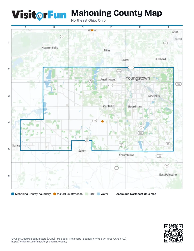
Street index of Mahoning County
Each street on the sheet and the grid squares it crosses.
- Mahoning AvenueB2, C2, D2, E2
- North Pricetown RoadB2
- South Pricetown RoadB2, B3, B4, B5
- Ellsworth-Bailey Road SouthwestC2
- North Bailey RoadC2
- North Salem Warren RoadC2
- Ohio TurnpikeC2, C3, D3, D4, E4, E5, F5
- South Salem Warren RoadC2, C3, C4, C5
- South Salem-Warren RoadC2
- Tod Avenue SouthwestC2
- North Canfield Niles RoadD2, D3
- North Meridian RoadD2
- Salt Springs RoadD2
- South Canfield Niles RoadD2, D3
- South Meridian RoadD2, D3
- Wickliffe ExpresswayD2, E2
- Albert StreetE2
- Belmont AvenueE2
- Burlington StreetE2
- Central SquareE2
- Division Street ExpresswayE2
- East Commerce StreetE2
- East Federal StreetE2
- East Gypsy LaneE2
- East Rayen AvenueE2
- East River CrossingE2
- East Woodland AvenueE2
- Eastbound Service RoadE2
- Fifth AvenueE2
- Glenwood AvenueE2, E3
- Gypsy LaneE2
- Hadnet DriveE2
- Himrod AvenueE2
- Hubbard RoadE2
- Madison AvenueE2
- Madison Avenue ExpresswayE2
- Market StreetE2, E3, E4, E5
- Martin Luther King Jr. BoulevardE2
- Martin Luther King Junior BoulevardE2
- McCartney RoadE2, E3, F3
- McGuffey RoadE2
- North Fruit StreetE2
- Oak StreetE2
- Poland AvenueE2, E3, F3
- Robert E. Hagan Memorial HighwayE2
- South AvenueE2, E3, E4, E5
- South Shore ExpresswayE2, E3
- Spring Common AvenueE2
- State StreetE2, E3, F3
- West Commerce StreetE2
- West Rayen AvenueE2
- West Woodland AvenueE2
- Westbound Service RoadE2
- Wick AvenueE2
- Wilson AvenueE2, E3, F3
- Wirt StreetE2
- Youngstown Hubbard RoadE2
- Coitsville-Hubbard RoadF2, F3
- Akron Canfield RoadB3, C3, D3
- Boardman Canfield RoadD3, E3
- Canfield RoadD3, E3
- East Main StreetD3
- Lisbon StreetD3
- Lockwood BoulevardD3, E3
- North Broad StreetD3
- Shields RoadD3, E3
- South Broad StreetD3, D4
- South Raccoon RoadD3
- Tippecanoe RoadD3
- West Main StreetD3, D5
- Youngstown Salem RoadD3, C4, D4, B5, C5
- Arden BoulevardE3
- Boardman ParkwayE3, E4
- Boardman Poland RoadE3
- Center RoadE3, F3
- Center StreetE3
- East McKinley WayE3
- East Midlothian BoulevardE3
- Lemoyne AvenueE3
- North Main StreetE3, B5, E5
- Poland Struthers RoadE3
- South Center StreetE3
- South Main StreetE3, B5
- Water StreetE3
- West Indianola AvenueE3
- West McKinley WayE3
- West Midlothian BoulevardE3
- Williamson AvenueE3
- Youngstown Pittsburgh RoadE3, E4, F4, F5
- Youngstown Poland RoadE3
- 1st StreetF3
- Ben Franklin ParkwayF3
- Broad StreetF3
- East Jackson StreetF3
- East Mc Gaffney AvenueF3
- East Mc Gaffney ExtendedF3
- East Wood StreetF3
- Lowellville RoadF3
- North Bridge StreetF3
- River RoadF3
- South Bridge StreetF3
- Struthers Coitsville RoadF3
- Upland AvenueF3
- Washington StreetF3
- West State StreetF3
- West Wood StreetF3
- Youngstown Lowellville RoadF3
- Cleveland East Liverpool RoadA4, B4, B5, C5
- State Route 14A4
- Beloit Snodes RoadB4, B5
- West South Range RoadB4, C4, D4, E4
- Columbiana Canfield RoadD4, D5, E5
- West Western Reserve RoadD4, E4
- East South Range RoadE4
- East Western Reserve RoadE4, F4
- Woodsworth RoadE4
- Woodworth RoadE4, E5, F5
- East Calla RoadF4
- East State StreetA5
- Harrisburg Westville RoadA5
- Mahoning Columbiana County Line RoadA5
- Alliance-Damascus RoadB5
- Alliance-Salem RoadB5
- Salem-Alliance RoadB5
- Salem Unity RoadC5, D5, E5
- Salem Warren RoadC5
- County Line Road EastE5
- East Garfield RoadE5, F5
- Mount Jackson RoadF5
- Pennsylvania TurnpikeF5
- Petersburg-Unity RoadF5
Things to do on the Mahoning County map
Places on the map
- Abbey Road Villas
- Akron Children's Hospital NICU at St. Elizabeth Boardman
- Anderson Farm
- Antonoff Pond
- Arrowhead Bay
- Arrowhead Lake
- Arrowhead Park
- Arthur Kyle Woods State Nature Preserve
- Austintown
- Austintown Plaza
- Austintown Township
- Austintown Township Park
- Beachwood Estates
- Beaver Township
- Bedford Trails Golf Course
- Beloit
- Berlin Airpark (Historic)
- Berlin Township
- Boardman
- Boardman Plaza
- Boardman Township
- Boardman Township Park
- Bradford Greene
- Brocker Field (Historic)
- Burgess Lake
- Calvary Cemetery
- Calvins Marsh
- Calvins Marsh Reservoir
- Camp Stambaugh
- Campbell
- Canfield
- Canfield Fairgrounds
- Canfield High School
- Canfield Township
- Canterbury Creek
- Carbon Limestone Sanitary Landfill
- Casey Industrial Park
- Catarina Place
- Central Waste Landfill (Closed 2014)
- Champ Park
Next to Mahoning County
- Alliance
- Columbiana
- East Palestine
- Farrell
- Girard
- Hubbard
- Newton Falls
- Niles
- Salem
- Sharon
- Warren
© OpenStreetMap contributors (ODbL) · Map data: Protomaps · Boundary: Who's On First (CC-BY 4.0)