

Ohio map
Perry Township map
About 28,270 people live here (Census Bureau, 2024 estimate). The sheet's index lists 300 streets; Richville Drive Southwest, Navarre Road Southwest and School Bus Loop cross the most grid squares. Things to do inside the boundary: Stark Parks.
Open the map (PDF, US Letter)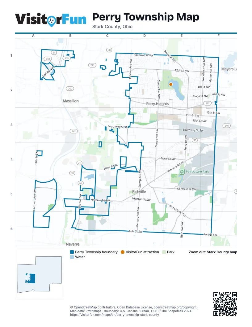
Street index of Perry Township
Each street on the sheet and the grid squares it crosses.
- Great Lakes Boulevard NorthwestB1, B4
- Lincoln Way EastD2, E2, E3
- Erie Avenue SouthwestB5, B6
- Tuscarawas Street WestE2, F2, E3
- Richville Drive SouthwestC3, C4, D4, D5, E5, E6, F6
- Faircrest Street SouthwestD5, E5, F5
- Earl Road NorthwestA1, B1, A2
- Orrville Street NorthwestA1, B1
- Whipple Avenue NorthwestF1, F2
- Erie Avenue NorthwestB1
- Walnut Road SoutheastC3
- Navarre Road SouthwestD4, E4, F4, B5, C5, D5
- 12th Street NorthwestD1, E1, F1
- Southway Street SouthwestD3, E3, F3
- Perry Drive SouthwestE3, E4, E5
- Genoa Avenue SouthwestD2, D3, D4, D5
- Shepler Church Avenue SouthwestE5, F5, E6
- Perry Drive NorthwestE1, E2, E3
- 13th Street SouthwestD3, E3, F3
- Woodlawn Avenue NorthwestF1, F2
- Nave Street SouthwestD4, E4
- Whipple Avenue SouthwestF2, F3, F4, F5, F6
- Genoa Avenue NorthwestD1, D2
- Jackson Avenue NorthwestD1, D2
- Carmont Avenue SouthwestA5, A6
- Bailey Street NorthwestD2, E2
- Stump Avenue SouthwestD4, D5
- Fohl Street SouthwestD6, E6, F6
- Kemary Avenue SouthwestD5, D6
- Nave Road SoutheastB4, C4
- Warmington Road SouthwestA5, B5
- Sherman Church Avenue SouthwestF6
- Southway Street SoutheastC3, D3
- Jackson Avenue SouthwestD3, D4
- Riverside Avenue NorthwestB1
- 11th Street SouthwestF3
- Hankins Road NorthwestC1, D1, C2
- Market Street NortheastB6
- Sterilite Street SoutheastC6
- 17th Street SouthwestA4
- Hankins Road NortheastC2
- 12th Street SouthwestD3, E3, F3
- Manor Avenue NorthwestF1, F2
- Ambrose Avenue NorthwestF1, F2
- Saratoga Avenue SouthwestE3, E4
- 4th Street NorthwestE2, F2
- Aurora Street NorthwestE2, F2
- Marion Avenue NorthwestD2
- Miles Avenue NorthwestF1, F2
- List Street NorthwestC1, D1
- Summerdale Avenue NorthwestD1, D2
- Leonard Avenue SouthwestE3, E4, E5
- Perry Hills Drive SouthwestD4, E4
- 2nd Street NorthwestE2, F2
- Roanoke Street NorthwestD1
- Brooklyn Avenue SouthwestE3, E4
- Highton Street SouthwestD5
- Tioga Street NorthwestE2, F2
- Hilton Street NorthwestD2
- 15th Street SouthwestE3, F3
- Bosford Street SouthwestD5
- 14th Street SouthwestE3, F3
- 17th Street NorthwestF1
- Drenta Circle SouthwestD6, E6
- Bordner Avenue SouthwestE2, E3, E4
- Saratoga Avenue NorthwestE2
- 16th Street NorthwestE1, F1
- Delaware Avenue SouthwestE3, E4
- Cincinnati Drive SouthwestC4, D4
- Roxbury Avenue NorthwestE2, E3
- 9th Street NorthwestE2, F2
- Beth Avenue SouthwestE6
- Chadwick Street NorthwestD1
- Anna Avenue NorthwestE2
- 15th Street NorthwestE1, F1
- 3rd Street NorthwestE2, F2
- Manor Avenue SouthwestF2, F3
- 14th Street NorthwestF1
- Mohawk Avenue NorthwestE2
- Delverne Avenue SouthwestF2, F3
- Piccadilly Street SouthwestE3, E4
- Clearbrook Road NorthwestD1
- Carmont Avenue NorthwestA1, A2
- Fairlane Avenue SouthwestF2, F3
- Miles Avenue SouthwestF2, F3
- Hancock Street SouthwestD4, E4
- Georgia Street NorthwestD2, E2
- Harding Avenue NorthwestE2
- Sippo Lake Park DriveE1, E2
- School Bus LoopF1, E2, F2, D3, E4, E5
- Oakvale Street SouthwestE4
- Pine Hills Drive SouthwestD3
- Monticello Street NorthwestE2, F2
- Meadowood Street NorthwestD1, D2
- Cayuga Avenue NorthwestE2
- Dunkeith Drive NorthwestE1, F1
- Spring Valley Avenue NorthwestE1
- Oneida Avenue NorthwestE2
- Kolpwood Avenue NorthwestD2
- Kendal Street SouthwestE4, F4
- Petros Lake Park DriveE4, E5
- Mollane Street NorthwestD2, E2
- Ellwood Avenue SouthwestF2, F3
- Snively Avenue NorthwestD2
- Richmont Avenue SouthwestD5
- Greenford Avenue SouthwestD5
- Kropf Avenue SouthwestE5
- Krisher Avenue SouthwestE4, E5
- Oakcliff Street SouthwestE4
- 7th Street NorthwestF2
- 13th Street NorthwestF1
- Leona Avenue SouthwestE6
- Barrie Street NorthwestE2, F2
- Lynncrest Street SouthwestE4
- 18th Street NorthwestE1, F1
- Warmont Avenue SouthwestB5
- Clark Street SouthwestD3, E3
- Western Avenue SouthwestF2, F3
- Overdale Avenue NorthwestF1, E2, F2
- Pheasant Grove Avenue NorthwestD2
- Sippo Avenue SouthwestE3, E4
- Westwood Street SouthwestD5
- Crown Point Street NorthwestD2
- Briardale Drive NorthwestD1
- Stewart Avenue NorthwestE2
- Klick Street SouthwestC5, D5
- Canford Avenue NorthwestD2
- Crescentview Drive SouthwestD2, D3
- Buckwalter Drive SouthwestD3
- Benjamin Street SouthwestD4, E4
- Harbrook Avenue SouthwestD5
- Rowford Avenue SouthwestD2, D3
- Shoreline Avenue NorthwestE2
- Foch Street NorthwestE2
- Lombardi Avenue SouthwestE4
- Netherwood Avenue NorthwestE2
- Dreamwood Avenue SouthwestE4
- Marcellus Street NorthwestF2
- Yukon Street NorthwestE2
- Chippendale Street NorthwestD1
- 7th Street SouthwestF2
- Brunnerdale Avenue NorthwestD1
- Harsh Street SouthwestD3
- Standish Avenue SouthwestD4
- Tennyson Street NorthwestC1, D1
- Elizabeth Avenue SouthwestD2, D3
- Wynnbrook Road SouthwestE4, D5
- Rowmont Road SouthwestD2, D3
- 5th Street NorthwestE2, F2
- Albany Drive NorthwestE2
- Peebles Street SouthwestB6
- Radcliff Avenue NorthwestC1
- Burlawn Street NorthwestE2
- 8th Street NorthwestF2
- Surmay Avenue SouthwestE5, E6
- Dresden Drive NorthwestE1
- 11th Street NorthwestF2
- Ridgewood Street SouthwestD4
- Groveland Avenue SouthwestD5
- Cadbury Avenue NorthwestD1
- Lennox Avenue NorthwestD2
- Quincy Street NorthwestE2
- Bernower Avenue SouthwestD2, D3
- Leo Avenue SouthwestF3, F4
- Tanya Avenue NorthwestD2
- Birchdale Street SouthwestD5, E5
- Sherwood Avenue NorthwestD1
- College Street SouthwestD5
- Nottingham Street NorthwestC1, D1
- Banyan Street NorthwestD2
- Dee Mar Avenue SouthwestD6
- Trafalgar Street SouthwestE4, F4
- Shermont Avenue SouthwestE5, E6
- Carlyle Street NorthwestC1, D1
- Shelia Street NorthwestD2
- Hazelbrook Street SouthwestD3, E3
- Bracken Road SouthwestE5, E6
- Allenwood Street SouthwestE5
- Gnau Avenue SouthwestD2, D3
- Jeffrey Avenue NorthwestD2
- Knollwood Road NorthwestE1, E2
- Severn Circle NorthwestE2
- Plymouth Knoll Avenue NorthwestD1
- Isler Circle NorthwestE1
- Mount Marie Avenue NorthwestE2
- Greenpark Street NorthwestD2
- Overmont Avenue SouthwestD2, D3
- Scheiring Avenue SouthwestE4
- Keller Road SouthwestD4
- Longbrook Street SouthwestD4, E4
- Longview Street SouthwestD4, E4
- Pershing Avenue NorthwestE2, E3
- Lennox Avenue SouthwestD2, D3
- Creston Road SouthwestD4
- Linway Avenue NorthwestD2
- Windamere Avenue NorthwestE2
- Elmford Avenue SouthwestD2, D3
- Floral Street SouthwestD3
- Ingall Avenue NorthwestD2
- Fairgrove Avenue SouthwestD5
- Patrick Street SouthwestD4, E4
- Fontana Street NorthwestC1, D1
- Mary Lou Street NorthwestC1, D1
- Barbie Avenue SouthwestC5, C6
- Victoria Avenue NorthwestF2
- Edgewater Avenue NorthwestE2, E3
- Jimmie Street SouthwestC5
- Avis Avenue NorthwestD2
- Austin Avenue NorthwestD2
- Darletta Street SouthwestD6, E6
- Stillmeadow Avenue SouthwestD4, D5
- Eden Avenue NorthwestE2, E3
- Wrexham Avenue SouthwestD2, D3
- Dodge Road SouthwestD4
- Ashwell AvenueD4
- Shirlie Avenue SouthwestC5
- Arbor Road SouthwestE3, F3
- Hinderer Avenue SouthwestD2, D3
- Edgewood Avenue SouthwestD3
- Leonard Avenue NorthwestE2, E3
- Highland Avenue SouthwestD2, D3
- Moock Avenue SouthwestE4
- Connecticut Street SouthwestD2
- Bellarbor Avenue NorthwestE2
- Negley Avenue SouthwestE4
- Roni Street SouthwestC5
- Fairlawn Avenue SouthwestE2, E3
- Knolls Avenue SouthwestD5
- Westland Avenue NorthwestE2, E3
- Rusty Avenue SouthwestE4
- Locke Avenue NorthwestE2
- Arrowbrook Street NorthwestE2
- Marsden Avenue SouthwestF2, F3
- Carriage Hill Avenue NorthwestD1
- Corrib Avenue NorthwestE1
- Stardale Avenue SouthwestD3
- Marta Street SouthwestD3
- Glenhurst Street SouthwestE4
- Charm Street SouthwestE4
- Harding Avenue SouthwestE2, E3
- Stevie LaneC5, C6
- Crestfield Street SouthwestD5, E5
- Dunbarton Drive NorthwestE1
- Hurless Drive SouthwestE5
- Charldon Avenue SouthwestD3
- Belle Avenue NorthwestD2
- Emil Avenue SouthwestD6
- Mason Street SouthwestD3
- Locke Avenue SouthwestE2, E3
- Colony Woods Circle SouthwestE4
- Kayview Street SouthwestA4
- Conover Street NorthwestD2
- Eddie Avenue SouthwestE5, E6
- Laurel Lane Street NorthwestE1
- 18th Street SouthwestE3
- Graydon Avenue SouthwestE4
- Stewart Avenue SouthwestE2, E3
- Adele Avenue NorthwestF2
- Sedwick Avenue NorthwestD1
- Cooper Avenue SouthwestD2, D3
- Parkland Avenue SouthwestD2, D3
- Tyner Street NorthwestE2
- Swiss Avenue SouthwestE4
- Westland Avenue SouthwestE3
- Kelford Street NorthwestA1
- Henry Street SouthwestB6
- Lachelle LaneC5
- Montrose Avenue NorthwestD2, E2
- Mapleford Street SouthwestB6
- Woodrich Street SouthwestD3
- Audrey Street SouthwestD5
- Carr Avenue SouthwestF4
- Oak Manor MhpD2
- Hopple Avenue SouthwestE3
- Parknoll Street SouthwestD4
- Alexander Avenue SouthwestD4
- Carolina Street NorthwestD2, E2
- Gauntlet Street SouthwestC5
- Thornridge Road NorthwestD1
- Tillman Street NorthwestD2, E2
- Lost Tree Drive NorthwestE1
- Zern Avenue SouthwestE3
- Wentworth Road SouthwestD4
- Hillmont Avenue SouthwestF6
- Canton Avenue NorthwestE1
- Mulheim Avenue SouthwestE5
- Roselawn Avenue SouthwestD5
- Proudley Avenue SouthwestD2, D3
- Citadel Avenue NorthwestD2
- Bergold Avenue SouthwestE3
- Cedar Knoll Avenue NorthwestD1
- Fairacres Street SouthwestD4
- 10th Street NorthwestF2
- Brook Avenue NorthwestD1, D2
- Louisa-Marie Avenue NorthwestC1
- Dupont Street NorthwestE2
- Shirley Ann Avenue SouthwestE4
- Stratford Street NorthwestD1
- Prosway Avenue SouthwestD5
- Murifield Avenue NorthwestE1
Things to do on the Perry Township map
Places on the map
- 84 Lumber
- AMF Hall of Fame Lanes
- AutoZone
- Calvary Cemetery
- Central Baptist Church
- Central High School
- Conservation Trail
- Cottonwood Trail
- CSE (Canton School Employees) Federal Credit Union
- Denny's
- Dollar General
- Dunkin'
- Eden Cemetery
- Emmanuel Christian Church
- Falcone's Tavern
- Fisher Foods
- Genoa Elementary School
- Glenhurst Park
- Grove Miller Park
- Hanover Healthcare Center
- Hearns Precision Automotive
- Huntington Bank
- Kelly's Auto Sales
- Lake Andreadis
- Marc's Stores
- McDonald's
- Meredith Park
- Neomodal Terminal
- Perry Heights
- Perry Park
- Perry Schools
- Perry Town Center
- Petros Lake
- Petros Lake Park
- Richville
- Richville Community Park
- Sippo Lake
- Sippo Lake Marina
- Sippo Lake Park
- Spring Valley Lake
Next to Perry Township
- Massillon map
- Meyers Lake
- Navarre
© OpenStreetMap contributors, Open Database License, openstreetmap.org/copyright · Map data: Protomaps · Boundary: U.S. Census Bureau, TIGER/Line Shapefiles 2024















