

Ohio map
Warren Township map
About 38,683 people live here (Census Bureau, 2024 estimate). The sheet's index lists 170 streets; North River Road Northwest, Layer Road and South Leavitt Road Southwest cross the most grid squares. Also on it: Leavittsburg, Canoe City Metropark and Skyway Drive-in.
Open the map (PDF, US Letter)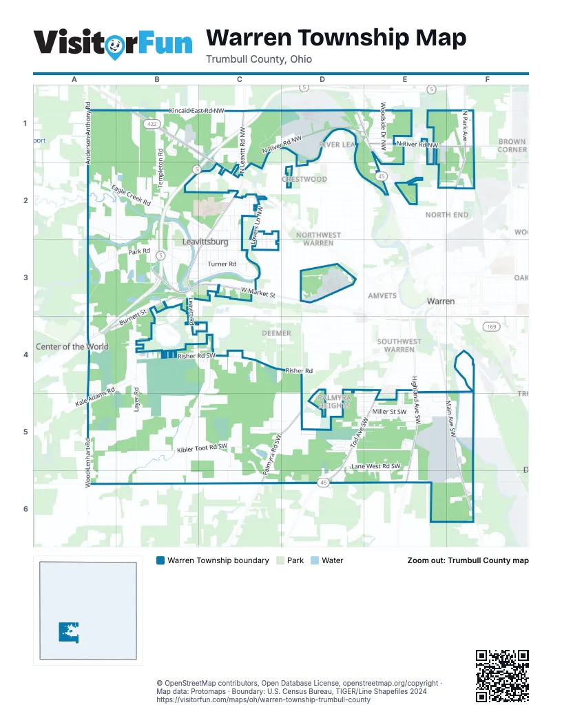
Street index of Warren Township
Each street on the sheet and the grid squares it crosses.
- Anderson Anthony RoadA1, A2
- Kincaid East Road NorthwestB1, C1
- Parkman Road NorthwestB1, C1, C2
- Pleasant Park Court NorthwestB1
- Roadside DriveB1, C1
- Templeton RoadB1, B2
- Templeton Road NorthwestB1
- Huntington DriveC1, C2
- Leavitt DriveC1
- North Leavitt Road NorthwestC1, C2
- North River Road NorthwestC1, D1, E1, F1, C2
- Pin Oak Lane NorthwestC1
- Riverside DriveC1
- Warren Outer BeltC1, B2, B3
- Mahoning Avenue NorthwestD1, E1, E2
- Rosedale AvenueD1, E1
- Althea Avenue NorthwestE1
- Brookside DriveE1, C2
- Coleridge Avenue NorthwestE1
- Ellsworth Avenue NorthwestE1
- Ferncliff Avenue NorthwestE1
- Grady Avenue NorthwestE1
- Greenlawn Avenue NorthwestE1
- Hawthorn AvenueE1
- Knox Avenue NorthwestE1
- Shady AvenueE1
- West Avenue NorthwestE1
- Woodside Drive NorthwestE1
- Wreyford Avenue NorthwestE1, E2
- Edison RoadF1, F2
- North Park AvenueF1, F2
- North River Road NortheastF1
- Eagle Creek RoadA2, B2, C2
- Nelson Mosier RoadA2, B2, B3
- Gillmer RoadB2, B3
- Potic DriveB2, B3, C3
- Riverview DriveB2, B3
- Bentz RoadC2, C3
- Bishop RoadC2, C3
- Briggs RoadC2, C3
- Burwell RoadC2, C3
- Dilley Road NorthwestC2, C3
- Dorothy AvenueC2
- Enterprise Drive NorthwestC2
- Gordon Road NorthwestC2, C3
- Kayser RoadC2, C3
- Lovers Lane NorthwestC2, C3
- Masters RoadC2
- McConnell RoadC2, C3
- McManus RoadC2, C3
- North Leavitt RoadC2, B3, C3
- Nottingham Street NorthwestC2, C3
- Orris RoadC2, C3
- Powrie RoadC2
- Rio Terra Street NorthwestC2
- Rio Vista RoadC2
- Seater Road NorthwestC2, C3
- Snyder RoadC2
- Solar Street NorthwestC2
- Wakefield RoadC2
- Winters RoadC2, C3
- Federal Street NorthwestE2, F2
- Northwest Bridge RoadE2
- Northwest Bridge Road NorthwestE2
- Post Street NorthwestE2
- Reo Street NorthwestE2, F2
- Sferra Avenue NorthwestE2
- Ivanhoe Avenue NortheastF2
- Diehl South RoadA3, A4
- Fisher AvenueA3
- Park RoadA3, B3
- Riverside StreetA3
- Woodview CircleA3
- Bachert RoadB3
- Bosworth StreetB3, C3
- Burnett StreetB3, A4, B4
- Caleb RoadB3, C3
- Cauffield RoadB3
- Clemens CourtB3
- Homeview AvenueB3
- Layer RoadB3, B4, B5, B6
- LeavittsburgB3
- Mahoning StreetB3
- Meadowbrook DriveB3, C3
- Pangborn RoadB3
- Parkview CourtB3
- Ruth AvenueB3
- South Leavitt RoadB3, B4
- South Street SouthwestB3
- Turner RoadB3, C3
- West Market StreetB3, C3, D3
- Bechtel RoadC3
- Caleb Road NorthwestC3
- Flora RoadC3
- Fuller Avenue NorthwestC3
- Hobart RoadC3
- Mateer RoadC3
- Meadowbrook Drive NorthC3
- Pendleton RoadC3
- Raveloe CourtC3
- Reserve Avenue SouthwestD3
- World Class Quality DriveD3
- Emert RoadA4
- Kale Adams RoadA4, B4, A5
- Manhattan AvenueA4
- Ritter RoadA4
- Choctaw AvenueB4, C4
- Midvak StreetB4
- Risher Road SouthwestB4, C4
- Wilda AvenueB4
- Millard Street SouthwestC4
- Peerless AvenueC4
- Risher RoadC4, D4
- South Leavitt Road SouthwestC4, B5, C5, B6
- 6th Street SouthwestD4, E4
- Colt Court SouthwestD4
- Palmyra Road SouthwestD4, C5, D5, C6
- York Avenue SouthwestD4, D5
- 6th StreetE4
- Bellcrest AvenueE4, E5
- Highland Avenue SouthwestE4, E5, E6
- Tod Avenue SouthwestE4, D5, E5, D6
- Valley Avenue SouthwestE4, E5
- Main Avenue SouthwestF4, F5, F6
- Wood Lenhart RoadA5, A6
- Kibler Toot Road SouthwestB5, C5
- Franwae Drive SouthwestC5, C6
- Jay StreetC5
- Kibbler Toot RoadC5, C6
- Melgren Drive SouthwestC5, D5
- Weilacher Road SouthwestC5, D5
- 4th StreetD5
- 5th StreetD5
- 7th Street SouthwestD5, E5, F5
- 8th Street SouthwestD5, E5, F5
- Baker Avenue SouthwestD5, E5
- Blossom Lane SouthwestD5
- Blueberry Lane SouthwestD5
- Bonnie Drive SouthwestD5
- East Apricot Drive SouthwestD5
- Karl Avenue SouthwestD5, E5
- Lane West Road SouthwestD5, E5
- Miller Street SouthwestD5, E5, F5
- Nevada Avenue SouthwestD5
- Orange Drive SouthwestD5
- Paxton Avenue SouthwestD5, E5
- Peach Lane SouthwestD5
- Richwood Avenue SouthwestD5, E5
- Salem-Warren RoadD5, D6
- Sassafras Lane SouthwestD5
- West Apricot Drive SouthwestD5
- 1st StreetE5
- 2nd StreetE5
- 3rd StreetE5
- Bane Street SouthwestE5, F5
- Beechwood Avenue SouthwestE5
- Bellecrest AvenueE5
- Davis Street SouthwestE5
- Dell Avenue SouthwestE5
- Dover Avenue SouthwestE5, F5
- Lyle Road SouthwestE5
- Sparks Avenue SouthwestE5
- Spruce Trail SouthwestE5
- Sycamore Trail SouthwestE5
- Thai Drive SouthwestE5
- Hewitt Gifford Road SouthwestA6, C6, D6
- Burnett East RoadE6, F6
- 27th StreetF6
- 28th StreetF6
- Santa FeF6
Places on the map
- Bascom Elementary School
- Canoe City Metropark
- Church of the Living God
- Evans Temple Church of God in Christ
- House of Israel Cemetery
- LaBrae High School
- Leavittsburg
- Leavittsburg Cemetery
- Leavittsburg Post Office
- Mahoning River Waterway Trail - Burbank Park Ingress / Egress
- Mahoning River Waterway Trail - Canoe City Egress / Portage
- Mahoning River Waterway Trail - Lynwood Emergency Egress
- Pine Knoll Cemetery
- Skyway Drive-in
Next to Warren Township
- Amvets
- Austin Village
- Brown Corner
- Center of the World
- Crestwood
- Deemer
- Elmwood
- Garden District
- Hardscrabble
- Historic Perkins District
- Iddings Park
- Jamestown Village
- Jefferson
- Mahoning Crest
- North End
- Northfield
- Northwest Warren
- Palmyra Heights
- Park Avenue Heights
- Parkwood
- Quinby
- River Lea
- Southwest Warren
- Starlite Estates
- The Peninsula
- Tod Heights
- Warren map
- Warren Commercial Historic District
- Wellesley Park
- Westlawn
© OpenStreetMap contributors, Open Database License, openstreetmap.org/copyright · Map data: Protomaps · Boundary: U.S. Census Bureau, TIGER/Line Shapefiles 2024















