

Oklahoma map
Norman map
About 131,010 people live here (Census Bureau, 2024 estimate). The sheet's index lists 300 streets; East Tecumseh Road, East Imhoff Road and East Rock Creek Road cross the most grid squares. Things to do inside the boundary: Lake Thunderbird State Park, Sam Noble Oklahoma Museum of Natural History and Sooner Mall.
Open the map (PDF, US Letter)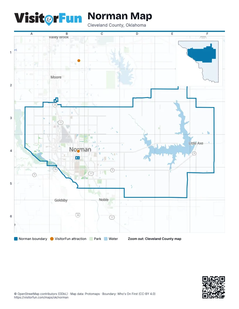
Street index of Norman
Each street on the sheet and the grid squares it crosses.
- Doctor James E. and Representative Mina M. Hibdon Memorial HighwayB3, B4
- Helen Cole Memorial HighwayB2, B3
- World War I Veterans Memorial HighwayB4
- McCall BridgeB4
- East Tecumseh RoadB3, C3, D3, E3, F3
- East Imhoff RoadD4, C5, D5, E5, F5
- West Tecumseh RoadA3, B3
- West Main StreetA4, B4
- 12th Avenue NortheastC3, C4
- North Flood AvenueB3, B4
- OK 9C5, D5
- 12th Avenue SoutheastC4, C5
- Classen BoulevardB4, C4, C5
- South Classen BoulevardC5
- North Main StreetC5
- East Robinson RoadF4
- East Rock Creek RoadB3, C3, D3, E3, F4
- East Lindsey StreetB4, C4, D4, E4, F4
- East Cedar Lane RoadB5, C5, D5, E5
- 24th Avenue NorthwestB3, B4
- East Alameda StreetB4, C4, D4, F4
- North Interstate DriveB3, B4
- East Robinson StreetB4, C4, D4
- 36th Avenue NorthwestB3, B4
- West Robinson StreetA4, B4
- North Porter AvenueB3, B4
- West Rock Creek RoadA3, B3
- Jenkins AvenueB4, B5
- 24th Avenue SoutheastC4, C5
- 60th Avenue NorthwestA3, A4
- West Lindsey StreetB4
- Chautauqua AvenueB4, B5
- Ed Noble ParkwayB4
- 24th Avenue SouthwestB4, B5
- East Main StreetB4, C4
- East Constitution StreetB5, C5
- Imhoff RoadB5
- 36th Avenue SouthwestB4
- West Gray StreetB4
- East Gray StreetB4
- Rock Creek RoadB3
- South Porter AvenueB4
- East Franklin RoadB3, C3, D3, E3, F3
- East Indian Hills RoadB3, C3, D3, E3, F3
- East Post Oak RoadC5, D5, E5
- East Etowah RoadD5, E5
- 108th Avenue NortheastE2, E3, E4
- 24th Avenue NortheastC3, C4
- West Franklin RoadA3, B3
- Alameda DriveD4, E4
- 84th Avenue NortheastD2, D3, D4
- 48th Avenue NorthwestA3, A4
- 60th Avenue SoutheastD4, D5
- 48th Avenue SoutheastC4, C5
- West Indian Hills RoadA3, B3
- 36th Avenue SoutheastC4, C5
- 120th Avenue SoutheastE4, E5
- Stella RoadD2, E2
- 12th Avenue NorthwestB3
- 156th Avenue SoutheastF4, F5
- Interstate DriveB2, B3, B4
- West Boyd StreetB4
- East Boyd StreetB4, C4, D4, E4
- South Berry RoadB4, B5
- South Pickard AvenueB4, B5
- Brookhaven BoulevardB3, A4, B4
- West Brooks StreetB4
- Elm AvenueB4
- North Berry RoadB4
- North Crawford AvenueB4
- North BroadwayB3
- East Interstate DriveB3
- North Peters AvenueB4
- East Brooks StreetB4, C4
- Stubbeman AvenueB3, B4
- South Flood AvenueB4
- Corporate Centre DriveB3
- West Imhoff RoadB5
- Wylie RoadB4
- South McGee DriveB4, B5
- Rambling Oaks DriveB4
- Oakhurst AvenueC4, C5
- Crossroads BoulevardB4
- South Asp AvenueB4, B5
- Lexington AvenueB4
- Melrose DriveB4
- Steamboat WayC5
- Oak Tree AvenueC5
- East Eufaula StreetB4, C4
- South Chautauqua AvenueB5
- North Findlay AvenueB4
- Beaumont DriveC4
- Morren DriveC4
- North University BoulevardB4
- West Acres StreetB4
- Vicksburg AvenueC4
- Technology PlaceC5
- East Johnson StreetB4
- Legacy Park DriveB4
- East Acres StreetB4
- River Oaks DriveB4
- Sandpiper LaneB4
- Asp AvenueB4
- David L Boren BoulevardB5
- Telluride LaneC4, C5
- Mount Williams WayB4
- McGee DriveB4
- South University BoulevardB4
- East Chesapeake StreetB5
- Bratcher-Miner RoadB5
- Boardwalk StreetB4
- Conference DriveB4
- Goddard AvenueB3, B4
- North Carter AvenueB4
- South Lake BoulevardC5
- Mount Williams DriveB4
- I-35 W Frontage RdB2, B3
- Brookhollow RoadA4, B4
- North Ponca AvenueB4
- Triad Village DriveC4
- Woods AvenueB4
- High Meadows DriveC4
- South Crawford AvenueB4
- Shiloh DriveC4
- South Santa Fe AvenueB4
- South Findlay AvenueB4
- Biloxi DriveC4
- Norman Center CourtB4
- John Saxon BoulevardC5
- Grandview AvenueA3, A4
- South Webster AvenueB4
- Goppold LaneB4
- Kingston RoadC3
- North 8th StreetC5
- Hemphill DriveB4
- North Webster AvenueB4
- Parkway DriveB4
- South Peters AvenueB4
- Hal Muldrow DriveB4
- Rock Creek TrailB3
- South Mercedes DriveB4
- South Jenkins AvenueB4
- Robinson DriveA4
- West Duffy StreetB4
- South Bryant AvenueB3
- South Eastern AvenueB3
- Southwest 24th AvenueB4
- North Santa Fe AvenueB4
- Southwest 34th StreetB2
- 120th Avenue NortheastE2, E3, E4
- 72nd Avenue SoutheastD4, D5
- 48th Avenue NortheastC3, C4
- 36th Avenue NortheastC3, C4
- 60th Avenue NortheastD3, D4
- 84th Avenue SoutheastD4, D5
- 168th Avenue NortheastF3, F4
- 72nd Avenue NortheastD3, D4
- 108th Avenue SoutheastE4, E5
- 156th Avenue NortheastF3, F4
- 180th Avenue NortheastF3, F4
- 144th Avenue NortheastE2, E3
- 132nd Indian Meridian Avenue SoutheastE5
- 96th Avenue NortheastD2, D3, D4
- Bethel RoadD2, E2, F2
- 96th Avenue SoutheastD4, D5
- Lett CircleE2
- Alameda StreetD4
- Little Gravel RoadF4
- Iowa StreetB4
- Winding Oaks LaneC4, C5
- Dakota StreetB4
- College AvenueB4
- 132nd Avenue NortheastE2, E3, E4
- 180th Avenue SoutheastF4, F5
- Wood Valley RoadC4, C5
- Indian Point RoadE3, E4
- 144th Avenue SoutheastE4, E5
- South Lahoma AvenueB4
- Twin Acres DriveC3
- Walnut RoadB5
- Eagle Cliff DriveC5
- Chaparral RoadE4, E5
- Manor Hill DriveA4
- 66th Avenue SoutheastD4, D5
- Astor DriveA3, B3
- Morning Glory DriveD5, E5
- Cruce StreetB4
- South Ponca AvenueB4
- West Symmes StreetB4
- West Timberdell RoadB4
- Nelson LaneE5
- Dare LaneD3, E3
- 72nd Avenue NorthwestA3
- Clear Bay AvenueE4
- Benny Bruce StreetD3
- Deer Creek RoadE2
- Barbour AvenueB4
- Old Oilfield RoadF4
- Ann Branden BoulevardC5
- Brownfield StreetD3
- Harrogate DriveA4, B4
- West Eufaula StreetB4
- Beverly Hills StreetB4
- Burning Tree StreetC4
- Monitor AvenueB5
- Day DriveD4
- Pudner DriveD5
- Storm King RoadD5, E5
- North Blue Lakes DriveB3
- Cabella CourtA4
- Hidden Hill RoadA4, B4
- West Comanche StreetB4
- Highland Hills DriveC4
- Quail Creek DriveD4, D5
- Denison DriveB4
- North Sherry AvenueB4
- Tallywood DriveE2, E3
- Westbrooke TerraceB4
- James Garner AvenueB4
- 79th Avenue NortheastD3, D4
- Allspice RunD5
- Southern Shores DriveE4
- East Frank StreetB4
- East Hughbert StreetB4
- Hickory RoadE3
- Vine StreetB4
- 91st Avenue NortheastD3
- Newton DriveB3, B4
- Kunkel AvenueE3
- Hollywood AvenueB4, B5
- East Comanche StreetB4, C4
- Norris CircleE5
- Hayfield RoadF4, F5
- Mesquite RoadE5
- Stardust LaneD3
- Skyler WayC5
- Westheimer DriveB4
- Nebraska StreetB4
- Kansas StreetB4
- Queenston AvenueC3
- Duke DriveE5
- Sexton DriveE5
- Calypso Cove AvenueE4
- Ridgeline DriveA3
- Spring View DriveD4
- Crocker StreetE4
- 7 A StreetF3
- Carrington LaneA3, B3
- Crooked Oak DriveD4
- Crickett LaneC3
- Cherry Stone StreetB4
- 142nd Avenue SoutheastE4, E5
- Countrywood EstatesE4, E5
- Daybreak DriveC4
- 141st Avenue NortheastE2
- Canterbury StreetB4
- East Symmes StreetB4, C4
- Hammer DriveC4
- Whitebrook StreetD3
- Central ParkwayC4
- Caddell LaneB4
- Blue Ridge DriveD5
- 156th Avenue Northeast / American Legion RoadF4
- 26th Avenue NorthwestB4
- 88th Avenue NortheastD4
- Juanita LaneF4
- Ridge Lake BoulevardC4
- Jackson DriveC4
- Firefly DriveC4
- Nelson RoadF3
- Highland ParkwayB4
- Isim RoadE3
- South Timberline DriveE3
- Oklahoma AvenueB4
- Griffin DriveB4, C4
- Wheaton DriveC4
- Diamond DriveF4
- Summit Crossing ParkwayC4
- Industrial BoulevardB3, B4
- Addison AvenueC5
- Clearwater DriveC4
- Summit Lake BoulevardC4
- 138th Avenue SoutheastE4, E5
- Nantucket BoulevardB3
- Lake RoadF3
- Highland Hills CircleC4
- Osprey DriveC5
- Kensal Rise PlaceA3
- Shoreline DriveC5
- G. T. Blankenship BoulevardB5
- North Lahoma AvenueB4
- Weymouth WayB3
- Brownwood LaneB3
- Burlwood RoadD4
- Sequoyah Trails DriveB3, C3
- Paloma PlaceC4
- North Pickard AvenueB4
- Stephan RoadF3
- Willowbend DriveB4
- Cannon DriveA3
Things to do on the Norman map
Places on the map
- Alcott Middle School
- Andrews Park
- Armed Forces Support Center
- Ashton Grove
- Behavioral Health Center at Porter Health Village
- Boyd R. Gunning Park
- Castlerock
- Cobblestone Creek Golf Course
- Colonial Estates
- Flaming Oaks
- Griffin Community Park
- Griffin Memorial Hospital
- Hall Park Lake
- Irving Middle School
- Jimmie Austin Golf Club
- Lake Thunderbird
- Lake Thunderbird State Park
- Normal Regional Hospital
- Norman North High School
- Oakhurst
- Oknoname 02715 Reservoir
- Oknoname 02717 Reservoir
- Oknoname 02719 Reservoir
- Oknoname 02720 Reservoir
- Oliver Wildlife Preserve
- OU Intramural/Recreation Field
- Parkway Plaza
- Reaves Park
- Reynolds Lake
- Ruby Grant Park
- Sooner Mall
- Summit Lake
- Sunrise Heights
- Sutton Urban Wilderness Park
- Terra Verde Discovery School
- The Links At Norman
- The Trails
- Thunderbird Loop
- University of Oklahoma
- Westwood Golf Course
Next to Norman
- Goldsby
- Moore map
- Noble
- Valley Brook
© OpenStreetMap contributors, Open Database License, openstreetmap.org/copyright · Map data: Protomaps · Boundary: Who's On First (CC-BY 4.0); Quattroshapes (CC BY 2.0)